Agnes Anna Owsley Gray
| Birth | : | 22 Apr 1868 Arcata, Humboldt County, California, USA |
| Death | : | 6 Dec 1943 Butte County, California, USA |
| Burial | : | East Jefferson Prairie Cemetery, Clinton, Rock County, USA |
| Coordinate | : | 42.4953003, -88.8332977 |
| Plot | : | Sec 22,I Lot 49 sp 1 |
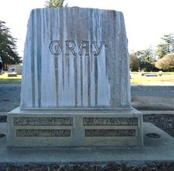
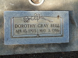
| Description | : | Chico Record, Chico, CA, Tuesday, Dec 7, 1943, pg 1: "Mrs. Agnes Gray Called By Death --- Mrs. Agnes A. Gray, 75, widely known resident of Chico for the past forty years and mother of Mrs. Dorothy Bell, died at her home 1142 South Broadway last evening after an illness of over four years. "Mrs. Gray was born at Arcata, California, April 22, 1868 and came with her husband the late Robert Gray, a plumber and sheet metal contractor, to Chico in 1904. Gray preceded his wife in death in 1926. "The deceased was a member of long... Read More |
frequently asked questions (FAQ):
-
Where is Agnes Anna Owsley Gray's memorial?
Agnes Anna Owsley Gray's memorial is located at: East Jefferson Prairie Cemetery, Clinton, Rock County, USA.
-
When did Agnes Anna Owsley Gray death?
Agnes Anna Owsley Gray death on 6 Dec 1943 in Butte County, California, USA
-
Where are the coordinates of the Agnes Anna Owsley Gray's memorial?
Latitude: 42.4953003
Longitude: -88.8332977
Family Members:
Spouse
Children
Flowers:
Nearby Cemetories:
1. East Jefferson Prairie Cemetery
Clinton, Rock County, USA
Coordinate: 42.4953003, -88.8332977
2. Jefferson Prairie Cemetery
Clinton, Rock County, USA
Coordinate: 42.4938000, -88.8646000
3. Stone School Cemetery
Boone County, USA
Coordinate: 42.4782982, -88.8035965
4. Oak Hill Cemetery
Boone County, USA
Coordinate: 42.4719009, -88.8897018
5. Saint Catherine Cemetery
Clinton, Rock County, USA
Coordinate: 42.5303001, -88.7866974
6. Center Cemetery
Boone County, USA
Coordinate: 42.4503784, -88.8719711
7. Blaine Cemetery
Blaine, Boone County, USA
Coordinate: 42.4472300, -88.8005300
8. Forest Hill Cemetery
Manchester Township, Boone County, USA
Coordinate: 42.4780998, -88.9180984
9. Bamblett Cemetery
Boone County, USA
Coordinate: 42.4575005, -88.9096985
10. Coynes Cemetery
Boone County, USA
Coordinate: 42.4289017, -88.7938995
11. Clinton Corners Cemetery
Clinton, Rock County, USA
Coordinate: 42.5539017, -88.8918991
12. South Grove Cemetery
Sharon, Walworth County, USA
Coordinate: 42.5331001, -88.7466965
13. Clinton Cemetery
Clinton, Rock County, USA
Coordinate: 42.5677986, -88.8589020
14. Summerville Cemetery
Clinton, Rock County, USA
Coordinate: 42.5713530, -88.8007520
15. Oakwood Cemetery
Sharon, Walworth County, USA
Coordinate: 42.5233002, -88.7313995
16. Livingston Cemetery
Boone County, USA
Coordinate: 42.4158510, -88.8801049
17. Burr Oak Cemetery
Boone County, USA
Coordinate: 42.4660400, -88.7200700
18. Mount Philip Cemetery
Clinton, Rock County, USA
Coordinate: 42.5819016, -88.7857971
19. North Sharon Cemetery
Sharon, Walworth County, USA
Coordinate: 42.5517006, -88.7268982
20. Dullam Cemetery
Capron, Boone County, USA
Coordinate: 42.4361000, -88.7253036
21. Carvers Rock Cemetery
Avalon, Rock County, USA
Coordinate: 42.6009600, -88.8285000
22. Shopiere Cemetery
Shopiere, Rock County, USA
Coordinate: 42.5675011, -88.9385986
23. Capron Cemetery
Capron, Boone County, USA
Coordinate: 42.3949190, -88.7403330
24. Valley of the Kings Sanctuary Burial Ground
Sharon, Walworth County, USA
Coordinate: 42.5296570, -88.6728190


