
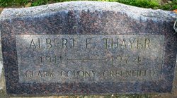
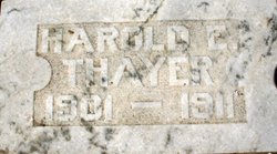
Albert Ernest Thayer
| Birth | : | 13 Dec 1911 Greenfield, Monterey County, California, USA |
| Death | : | 5 Jun 1974 Monterey, Monterey County, California, USA |
| Burial | : | Greenfield Cemetery, Greenfield, Monterey County, USA |
| Coordinate | : | 36.3347130, -121.2128372 |
| Inscription | : | Clark Colony Greenfield |
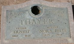
| Description | : | Parents: Ernest and Nora Belle (Forsyth) Thayer. |
frequently asked questions (FAQ):
-
Where is Albert Ernest Thayer's memorial?
Albert Ernest Thayer's memorial is located at: Greenfield Cemetery, Greenfield, Monterey County, USA.
-
When did Albert Ernest Thayer death?
Albert Ernest Thayer death on 5 Jun 1974 in Monterey, Monterey County, California, USA
-
Where are the coordinates of the Albert Ernest Thayer's memorial?
Latitude: 36.3347130
Longitude: -121.2128372
Family Members:
Parent

Spouse
Siblings
Children
Flowers:


Nearby Cemetories:
1. Greenfield Holy Trinity Cemetery
Greenfield, Monterey County, USA
Coordinate: 36.3164139, -121.2428131
2. Soledad Cemetery
Soledad, Monterey County, USA
Coordinate: 36.4275131, -121.3124542
3. Soledad Mission Cemetery
Soledad, Monterey County, USA
Coordinate: 36.4047460, -121.3561260
4. King City Cemetery
King City, Monterey County, USA
Coordinate: 36.2066078, -121.1374207
5. San Benito County Cemetery
Hollister, San Benito County, USA
Coordinate: 36.4859009, -121.2306976
6. Bitterwater Cemetery
Rock Spring Peak, San Benito County, USA
Coordinate: 36.4006004, -120.9916992
7. Gonzales Cemetery
Gonzales, Monterey County, USA
Coordinate: 36.4947014, -121.4300003
8. Mansfield Cemetery
King City, Monterey County, USA
Coordinate: 36.1030320, -121.1478060
9. Willow Creek Cemetery
San Benito County, USA
Coordinate: 36.5957985, -121.1903000
10. San Lucas Cemetery
San Lucas, Monterey County, USA
Coordinate: 36.1258354, -121.0134735
11. Barbree Ranch Cemetery
San Lucas, Monterey County, USA
Coordinate: 36.0914030, -121.0822670
12. Long Valley Cemetery
San Lucas, Monterey County, USA
Coordinate: 36.1467700, -120.9545100
13. Mission San Antonio de Padua Cemetery
Monterey County, USA
Coordinate: 36.0153313, -121.2502441
14. Cherry Hill Cemetery
Panoche, San Benito County, USA
Coordinate: 36.6150017, -120.9586029
15. Sierra Camp Cemetery
Jolon, Monterey County, USA
Coordinate: 35.9840900, -121.2285400
16. Dutton Hotel Burial Site
Jolon, Monterey County, USA
Coordinate: 35.9749220, -121.1757270
17. Jolon Cemetery
Jolon, Monterey County, USA
Coordinate: 35.9713478, -121.1769333
18. Paris Valley Cemetery
Monterey County, USA
Coordinate: 36.0230828, -120.9571273
19. Gil Family Cemetery
Jolon, Monterey County, USA
Coordinate: 35.9609220, -121.1890660
20. Paicines Cemetery
Paicines, San Benito County, USA
Coordinate: 36.7088580, -121.2456330
21. Paulsen Cemetery
Monterey County, USA
Coordinate: 35.9663353, -121.0780716
22. San Ardo Cemetery
San Ardo, Monterey County, USA
Coordinate: 36.0269089, -120.9120941
23. New Camaldoli Hermitage Cemetery
Big Sur, Monterey County, USA
Coordinate: 36.0261536, -121.5360947
24. Clayton Cemetery
Priest Valley, San Benito County, USA
Coordinate: 36.2028008, -120.7285995