
| Birth | : | 1876 Dayton, Green County, Wisconsin, USA |
| Death | : | 10 Oct 1952 USA |
| Burial | : | Calvary Cemetery, Pocahontas, Pocahontas County, USA |
| Coordinate | : | 42.7335000, -94.6597000 |
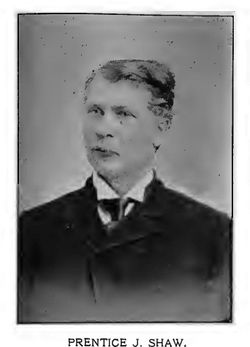
| Description | : | From Pocahontas County History Published 1982 page 661 Albert Josiah Shaw, school teacher, attorney, legislator, and public servant was born 1876 at Dayton, (Green County), Wisconsin the son of Prentice and Jennie A. Shaw, and died 10 October 1952, as a result of a cerebral hemorrhage on 6 July of the same year. In 1882 he came with his parents to Iowa and spent his childhood mainly on a farm in Powhatan Township. He received his elementary and high school education in Rolfe and Plover, and attended Cornell College, Mt. Vernon. After a short period of teaching, he went to Des Moines... Read More |
frequently asked questions (FAQ):
-
Where is Albert Josiah “Burt” Shaw's memorial?
Albert Josiah “Burt” Shaw's memorial is located at: Calvary Cemetery, Pocahontas, Pocahontas County, USA.
-
When did Albert Josiah “Burt” Shaw death?
Albert Josiah “Burt” Shaw death on 10 Oct 1952 in USA
-
Where are the coordinates of the Albert Josiah “Burt” Shaw's memorial?
Latitude: 42.7335000
Longitude: -94.6597000
Family Members:
Parent
Spouse

Siblings
Children
Flowers:


Nearby Cemetories:
1. Calvary Cemetery
Pocahontas, Pocahontas County, USA
Coordinate: 42.7335000, -94.6597000
2. Summit Hill Cemetery
Pocahontas, Pocahontas County, USA
Coordinate: 42.7315000, -94.6595000
3. Grant Township Cemetery
Pocahontas, Pocahontas County, USA
Coordinate: 42.6571999, -94.6996994
4. Saint Josephs Cemetery
Palmer, Pocahontas County, USA
Coordinate: 42.6342010, -94.6188965
5. Washington Cemetery
Havelock, Pocahontas County, USA
Coordinate: 42.8363250, -94.7091440
6. Evangelical Covenant Cemetery
Pomeroy, Calhoun County, USA
Coordinate: 42.6165720, -94.6803640
7. Elfsborg Lutheran Cemetery
Palmer, Pocahontas County, USA
Coordinate: 42.6169014, -94.6875000
8. Swedish Mission Bethany Cemetery
Pocahontas County, USA
Coordinate: 42.6138992, -94.6774979
9. Clinton-Garfield Cemetery
Rolfe, Pocahontas County, USA
Coordinate: 42.8055300, -94.5202500
10. Saint Margarets Cemetery
Rolfe, Pocahontas County, USA
Coordinate: 42.8164978, -94.5307465
11. Saint Paul Lutheran Cemetery
Palmer, Pocahontas County, USA
Coordinate: 42.6176000, -94.5893500
12. Palmer Cemetery
Palmer, Pocahontas County, USA
Coordinate: 42.6166992, -94.5894012
13. Powhatan Cemetery
Plover, Pocahontas County, USA
Coordinate: 42.8557396, -94.5801773
14. Saint Johns Catholic Cemetery
Gilmore City, Pocahontas County, USA
Coordinate: 42.7332993, -94.4672012
15. Saint Johns Lutheran Cemetery
Palmer, Pocahontas County, USA
Coordinate: 42.6268997, -94.5205994
16. Dover Township Cemetery
Varina, Pocahontas County, USA
Coordinate: 42.6896100, -94.8524200
17. Marble Valley Cemetery
Gilmore City, Humboldt County, USA
Coordinate: 42.7458850, -94.4430150
18. Saint Columbkilles Cemetery
Varina, Pocahontas County, USA
Coordinate: 42.6467018, -94.8443985
19. Calvary Cemetery
Laurens, Pocahontas County, USA
Coordinate: 42.8403015, -94.8368988
20. Laurens Cemetery
Laurens, Pocahontas County, USA
Coordinate: 42.8438988, -94.8330994
21. Old Rolfe Cemetery
Rolfe, Pocahontas County, USA
Coordinate: 42.8403511, -94.4764175
22. Marshall Cemetery
Pocahontas County, USA
Coordinate: 42.7633018, -94.8930969
23. Saint Marys Catholic Cemetery
Pomeroy, Calhoun County, USA
Coordinate: 42.5558014, -94.6889038
24. Union Cemetery
Pomeroy, Calhoun County, USA
Coordinate: 42.5539017, -94.6789017