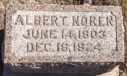
Albert Noren
| Birth | : | 14 Jun 1903 Kansas, USA |
| Death | : | 19 Dec 1924 Nuckolls County, Nebraska, USA |
| Burial | : | Papakura Cemetery, Papakura, Auckland Council, New Zealand |
| Coordinate | : | -37.0698600, 174.9448300 |
| Description | : | ONE KILLED IN AUTO CRASH. Superior, Dec. 21. - X-ray examinations revealed that Leota Noren, thirty-three year old wife of Edward Noren, driver of the auto in a fatal accident at a crossing two miles west of here Friday night, sustained a badly fractured pelvis bone, and serious body bruises and cuts, which will confine her to her bed for two months. Edward Noren was not found to be seriously injured, although suffering from fractured ribs and bad cuts. Albert Noren, brother of Edward, was killed. The train and auto collided. It was decided by authorities here Saturday afternoon... Read More |
frequently asked questions (FAQ):
-
Where is Albert Noren's memorial?
Albert Noren's memorial is located at: Papakura Cemetery, Papakura, Auckland Council, New Zealand.
-
When did Albert Noren death?
Albert Noren death on 19 Dec 1924 in Nuckolls County, Nebraska, USA
-
Where are the coordinates of the Albert Noren's memorial?
Latitude: -37.0698600
Longitude: 174.9448300
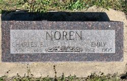
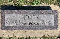
Family Members:
Parent
Siblings
Flowers:
Nearby Cemetories:
1. Papakura Cemetery
Papakura, Auckland Council, New Zealand
Coordinate: -37.0698600, 174.9448300
2. Papakura South Cemetery
Papakura, Auckland Council, New Zealand
Coordinate: -37.0877300, 174.9464700
3. Drury Presbyterian Cemetery
Drury, Auckland Council, New Zealand
Coordinate: -37.0991270, 174.9497870
4. Drury-Runciman War Memorial
Drury, Auckland Council, New Zealand
Coordinate: -37.1025480, 174.9528240
5. St John's Anglican Cemetery Drury
Drury, Auckland Council, New Zealand
Coordinate: -37.1033710, 174.9506070
6. St James Churchyard Ardmore
Auckland Council, New Zealand
Coordinate: -37.0364180, 174.9992160
7. Alfriston Cemetery
Auckland Council, New Zealand
Coordinate: -37.0133660, 174.9479400
8. Laurie-Gibbons Memorial Park
Weymouth, Auckland Council, New Zealand
Coordinate: -37.0440600, 174.8586790
9. Pratt's Road Catholic Cemetery
Ramarama, Auckland Council, New Zealand
Coordinate: -37.1425500, 174.9871300
10. St. David's Anglican Churchyard
Wiri, Auckland Council, New Zealand
Coordinate: -37.0025400, 174.8886150
11. Woodside Methodist Cemetery
Manukau, Auckland Council, New Zealand
Coordinate: -36.9929680, 174.8837860
12. Ararimu Cemetery
Ararimu, Auckland Council, New Zealand
Coordinate: -37.1321000, 175.0484200
13. Hunua Presbyterian Cemetery
Hunua, Auckland Council, New Zealand
Coordinate: -37.0792290, 175.0742700
14. Ararimu Schoolhouse Cemetery
Ararimu, Auckland Council, New Zealand
Coordinate: -37.1448376, 175.0359288
15. St Andrews Presbyterian Cemetery
Clevedon, Auckland Council, New Zealand
Coordinate: -36.9921320, 175.0371370
16. St. Paul's Anglican Cemetery
East Tamaki, Auckland Council, New Zealand
Coordinate: -36.9615200, 174.9082000
17. Manukau Memorial Gardens
Manukau, Auckland Council, New Zealand
Coordinate: -36.9944380, 174.8397300
18. Bombay Presbyterian Church Cemetery
Bombay, Auckland Council, New Zealand
Coordinate: -37.1790700, 174.9826900
19. Clevedon Cemetery All Souls Church
Clevedon, Auckland Council, New Zealand
Coordinate: -36.9862400, 175.0418100
20. Heights Park Cemetery
Paerata, Auckland Council, New Zealand
Coordinate: -37.1781928, 174.8938836
21. Flat Bush Cemetery
East Tamaki, Auckland Council, New Zealand
Coordinate: -36.9563500, 174.9097100
22. Papatoetoe Cemetery
Papatoetoe, Auckland Council, New Zealand
Coordinate: -36.9893110, 174.8373530
23. Pukekohe East Cemetery
Pukekohe East, Auckland Council, New Zealand
Coordinate: -37.1883500, 174.9459000
24. St. Peter's in the Forest Anglican Cemetery
Bombay, Auckland Council, New Zealand
Coordinate: -37.1869100, 174.9914100


