
| Memorials | : | 9 |
| Location | : | Pukekohe East, Auckland Council, New Zealand |
| Coordinate | : | -37.1883500, 174.9459000 |
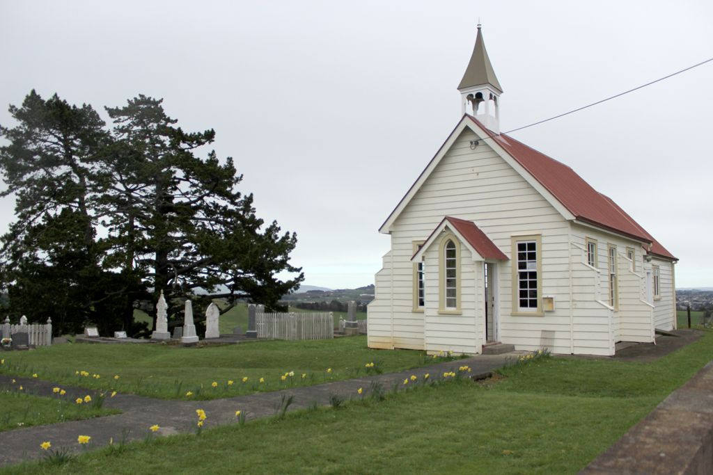
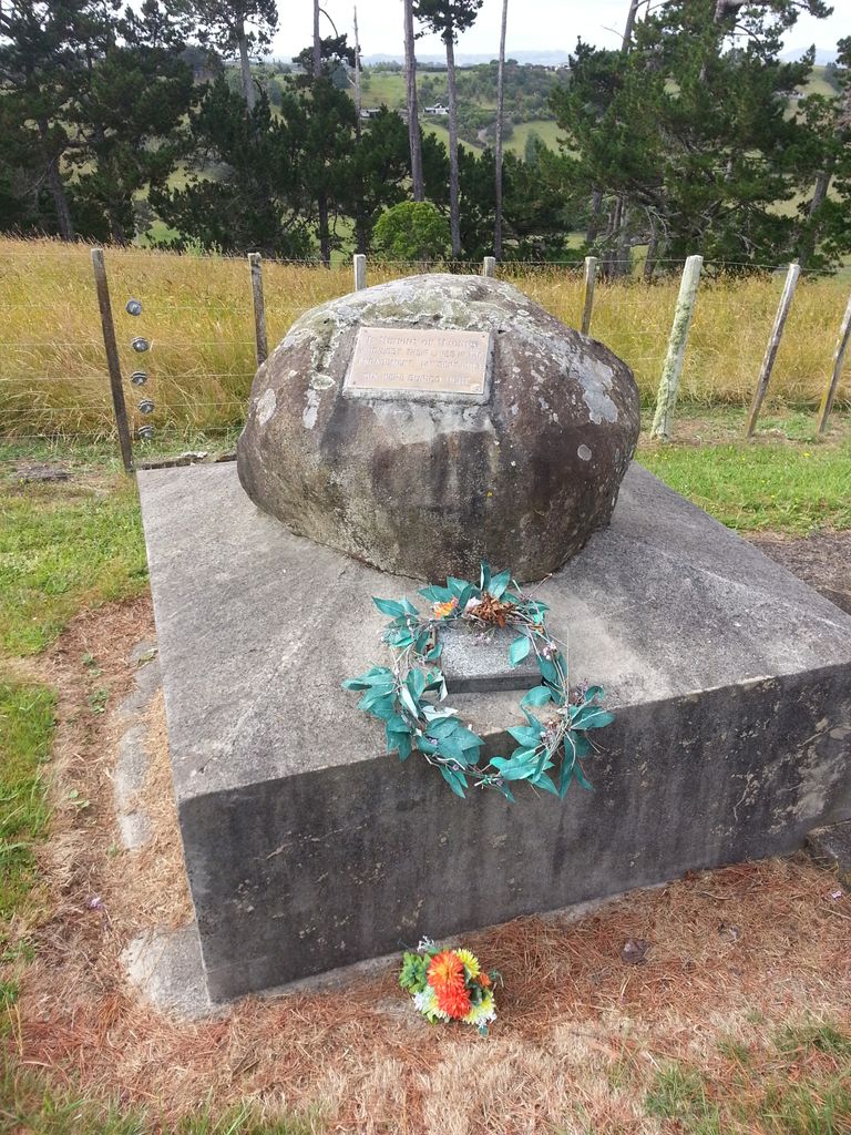
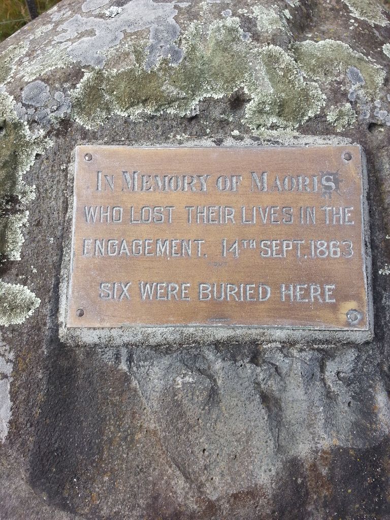
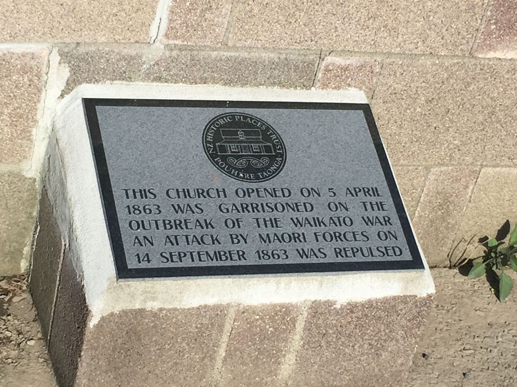
| Description | : | This church was the scene of one of the first battles of the Waikato War of 1863-64. On 14 September 1863 a sizeable raiding party, most of them Ngati Maniapoto, attacked the Pukekohe East Church, around which a stockade had been built. Inside were seventeen local men serving as militia. A battle ensued and the militiamen were able to hold out until reinforcements arrived from nearby camps. Evidence of the attack is seen in the bullet holes in the walls of the church. There is a memorial to the Maori who died in the battle, six of whom are buried in... Read More |
frequently asked questions (FAQ):
-
Where is Pukekohe East Cemetery?
Pukekohe East Cemetery is located at 95 Runciman Road Pukekohe East, Auckland Council ,Auckland , 2677New Zealand.
-
Pukekohe East Cemetery cemetery's updated grave count on graveviews.com?
9 memorials
-
Where are the coordinates of the Pukekohe East Cemetery?
Latitude: -37.1883500
Longitude: 174.9459000
Nearby Cemetories:
1. Bombay Presbyterian Church Cemetery
Bombay, Auckland Council, New Zealand
Coordinate: -37.1790700, 174.9826900
2. Pukekohe Catholic Cemetery
Pukekohe, Auckland Council, New Zealand
Coordinate: -37.1951510, 174.9014640
3. St. Peter's in the Forest Anglican Cemetery
Bombay, Auckland Council, New Zealand
Coordinate: -37.1869100, 174.9914100
4. Heights Park Cemetery
Paerata, Auckland Council, New Zealand
Coordinate: -37.1781928, 174.8938836
5. Pukekohe Public Cemetery
Pukekohe, Auckland Council, New Zealand
Coordinate: -37.2106400, 174.8974900
6. Pratt's Road Catholic Cemetery
Ramarama, Auckland Council, New Zealand
Coordinate: -37.1425500, 174.9871300
7. Pokeno Old Soldiers Cemetery
Pokeno, Waikato District, New Zealand
Coordinate: -37.2386120, 175.0094760
8. Pokeno Cemetery
Pokeno, Waikato District, New Zealand
Coordinate: -37.2364600, 175.0215400
9. Ararimu Schoolhouse Cemetery
Ararimu, Auckland Council, New Zealand
Coordinate: -37.1448376, 175.0359288
10. St John's Anglican Cemetery Drury
Drury, Auckland Council, New Zealand
Coordinate: -37.1033710, 174.9506070
11. Drury-Runciman War Memorial
Drury, Auckland Council, New Zealand
Coordinate: -37.1025480, 174.9528240
12. Drury Presbyterian Cemetery
Drury, Auckland Council, New Zealand
Coordinate: -37.0991270, 174.9497870
13. Tuakau Cemetery
Tuakau, Waikato District, New Zealand
Coordinate: -37.2844420, 174.9465660
14. Alexandra Redoubt Cemetery
Tuakau, Waikato District, New Zealand
Coordinate: -37.2858200, 174.9419600
15. Ararimu Cemetery
Ararimu, Auckland Council, New Zealand
Coordinate: -37.1321000, 175.0484200
16. Papakura South Cemetery
Papakura, Auckland Council, New Zealand
Coordinate: -37.0877300, 174.9464700
17. St Brides Church of England Cemetery
Mauku, Auckland Council, New Zealand
Coordinate: -37.2011260, 174.8120370
18. Mauku Cemetery
Mauku, Auckland Council, New Zealand
Coordinate: -37.2011420, 174.8109100
19. Papakura Cemetery
Papakura, Auckland Council, New Zealand
Coordinate: -37.0698600, 174.9448300
20. Mauku Historical Cemetery
Mauku, Auckland Council, New Zealand
Coordinate: -37.1743690, 174.7951870
21. Mercer Cemetery
Mercer, Waikato District, New Zealand
Coordinate: -37.2764860, 175.0578300
22. Onewhero Cemetery
Onewhero, Waikato District, New Zealand
Coordinate: -37.3158900, 174.9104900
23. Hunua Presbyterian Cemetery
Hunua, Auckland Council, New Zealand
Coordinate: -37.0792290, 175.0742700
24. St James Churchyard Ardmore
Auckland Council, New Zealand
Coordinate: -37.0364180, 174.9992160