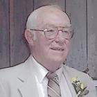
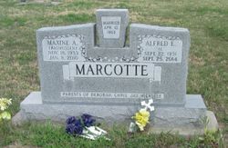
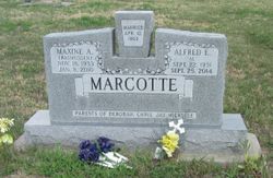
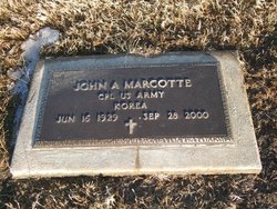
Alfred Eugene Marcotte
| Birth | : | 22 Sep 1931 Cloud County, Kansas, USA |
| Death | : | 25 Sep 2014 Westmoreland, Pottawatomie County, Kansas, USA |
| Burial | : | Morganville City Cemetery, Morganville, Clay County, USA |
| Coordinate | : | 39.4733009, -97.1819000 |
| Inscription | : | PARENTS OF DEBORAH, CHRIS, JAY, MICHELLE |
| Description | : | ALFRED MARCOTTE, 83, died September 25, 2014 at Westy Community Care Home in Westmoreland, KS. He was born on September 22, 1931 in Cloud County, KS. The son of Arthur and Elsie (Loughry). Alfred was raised in the Jamestown and Concordia communities. He graduated from Notre Dame High School in Concordia. Alfred served in the US Air Force during the Korean War. He married Maxine Rasmussen on April 10, 1953. Alfred worked for Safeway Grocery in Manhattan. He purchased and operated the grocery store and locker plant in Morganville in January 1970. In 1985, Alfred opened Marcotte Insurance.... Read More |
frequently asked questions (FAQ):
-
Where is Alfred Eugene Marcotte's memorial?
Alfred Eugene Marcotte's memorial is located at: Morganville City Cemetery, Morganville, Clay County, USA.
-
When did Alfred Eugene Marcotte death?
Alfred Eugene Marcotte death on 25 Sep 2014 in Westmoreland, Pottawatomie County, Kansas, USA
-
Where are the coordinates of the Alfred Eugene Marcotte's memorial?
Latitude: 39.4733009
Longitude: -97.1819000
Family Members:
Parent
Spouse
Siblings
Children
Flowers:
Nearby Cemetories:
1. Morganville City Cemetery
Morganville, Clay County, USA
Coordinate: 39.4733009, -97.1819000
2. Norwegian Lutheran Cemetery
Clay Center, Clay County, USA
Coordinate: 39.5027900, -97.1828200
3. Swedish Evangelical Lutheran Cemetery
Clay County, USA
Coordinate: 39.4911700, -97.1455100
4. Swedish Pleasant Hill Cemetery
Clay Center, Clay County, USA
Coordinate: 39.4735985, -97.1268997
5. Garfield Center Mission Cemetery
Clay Center, Clay County, USA
Coordinate: 39.5243100, -97.1277500
6. Sherman Cemetery
Morganville, Clay County, USA
Coordinate: 39.5316300, -97.2243700
7. Bloom Cemetery
Morganville, Clay County, USA
Coordinate: 39.4519005, -97.2778015
8. Hayes Cemetery
Clay County, USA
Coordinate: 39.4516983, -97.0811005
9. Greenwood Cemetery
Clay Center, Clay County, USA
Coordinate: 39.4011002, -97.1275024
10. Saint Peter and Saint Pauls Catholic Cemetery
Clay Center, Clay County, USA
Coordinate: 39.4005450, -97.1236680
11. Idylwilde Cemetery
Clay Center, Clay County, USA
Coordinate: 39.5097900, -97.0713000
12. Wilson Cemetery
Clay County, USA
Coordinate: 39.3800011, -97.1896973
13. Riverdale Cemetery
Clay County, USA
Coordinate: 39.5106010, -97.2930984
14. Lincoln Cemetery
Clay Center, Clay County, USA
Coordinate: 39.4230995, -97.2930984
15. Brethren in Christ Cemetery
Clay County, USA
Coordinate: 39.4810982, -97.0344009
16. Joseph Sender Family Cemetery
Clay County, USA
Coordinate: 39.5090600, -97.0348800
17. Clay County Poor Farm Cemetery
Clay Center, Clay County, USA
Coordinate: 39.3772700, -97.0727000
18. Republican City Cemetery
Clay Center, Clay County, USA
Coordinate: 39.3431015, -97.1628036
19. Iwacura Cemetery
Morganville, Clay County, USA
Coordinate: 39.4550000, -97.3510000
20. Goshen Central Cemetery
Clay Center, Clay County, USA
Coordinate: 39.5099983, -97.0160980
21. Idana Cemetery
Idana, Clay County, USA
Coordinate: 39.3574500, -97.2693300
22. Fancy Creek Cemetery
Green, Clay County, USA
Coordinate: 39.4668999, -96.9969025
23. Appleton Cemetery
Clay County, USA
Coordinate: 39.5250015, -96.9972000
24. Green Cemetery
Green, Clay County, USA
Coordinate: 39.4235992, -96.9882965

