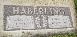
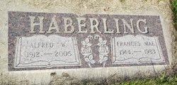
Alfred Haberling
| Birth | : | 10 Dec 1912 Hand County, South Dakota, USA |
| Death | : | 16 Jul 2005 Faulkton, Faulk County, South Dakota, USA |
| Burial | : | Southborough Cemetery, Southborough, Tunbridge Wells Borough, England |
| Coordinate | : | 51.1592860, 0.2420140 |
| Description | : | Alfred Haberling, age 92, of Faulkton, S.D., died Saturday, July 16, 2005, at the Faulkton Healthcare Center. The funeral service will be at 2 p.m. Thursday, July 21, at Our Savior Lutheran Church, Faulkton, with the Rev. Junfeng Tan officiating. Burial will be in Prairie View Cemetery, Orient, under the direction of Luce Funeral Home, Faulkton. Alfred W. Haberling was born December 10, 1912 to Charles N. and Emma (Neiderbaumer) Haberling in Hand County. He was baptized December 20, 1912, and confirmed September 12, 1926 at St. Michael's Church near Polo. Alfred grew up in the Orient area. He was united in... Read More |
frequently asked questions (FAQ):
-
Where is Alfred Haberling's memorial?
Alfred Haberling's memorial is located at: Southborough Cemetery, Southborough, Tunbridge Wells Borough, England.
-
When did Alfred Haberling death?
Alfred Haberling death on 16 Jul 2005 in Faulkton, Faulk County, South Dakota, USA
-
Where are the coordinates of the Alfred Haberling's memorial?
Latitude: 51.1592860
Longitude: 0.2420140
Family Members:
Parent
Spouse
Siblings
Flowers:
Nearby Cemetories:
1. Southborough Cemetery
Southborough, Tunbridge Wells Borough, England
Coordinate: 51.1592860, 0.2420140
2. St. Peter's Churchyard
Southborough, Tunbridge Wells Borough, England
Coordinate: 51.1626549, 0.2520690
3. St. Lawrence Churchyard
Bidborough, Tunbridge Wells Borough, England
Coordinate: 51.1666950, 0.2371870
4. Southborough War Memorial
Southborough, Tunbridge Wells Borough, England
Coordinate: 51.1639214, 0.2528920
5. St. Mary the Virgin Churchyard
Speldhurst, Tunbridge Wells Borough, England
Coordinate: 51.1510790, 0.2198230
6. St John's Church
Royal Tunbridge Wells, Tunbridge Wells Borough, England
Coordinate: 51.1402330, 0.2608070
7. St Paul New Churchyard
Rusthall, Tunbridge Wells Borough, England
Coordinate: 51.1401520, 0.2204420
8. Woodbury Park Cemetery
Royal Tunbridge Wells, Tunbridge Wells Borough, England
Coordinate: 51.1389847, 0.2637900
9. Hanover Strict Baptist Chapel
Royal Tunbridge Wells, Tunbridge Wells Borough, England
Coordinate: 51.1356700, 0.2625100
10. St. Paul's Churchyard
Rusthall, Tunbridge Wells Borough, England
Coordinate: 51.1307144, 0.2376710
11. All Souls Churchyard
Poundsbridge, Sevenoaks District, England
Coordinate: 51.1540700, 0.1961470
12. Trinity Churchyard
Royal Tunbridge Wells, Tunbridge Wells Borough, England
Coordinate: 51.1328200, 0.2623600
13. St Stephens
Tonbridge, Tonbridge and Malling Borough, England
Coordinate: 51.1893961, 0.2687135
14. All Saints Churchyard
Langton Green, Tunbridge Wells Borough, England
Coordinate: 51.1309738, 0.2022060
15. St. John the Baptist Churchyard
Penshurst, Sevenoaks District, England
Coordinate: 51.1735240, 0.1834540
16. St. Mary's Churchyard
Leigh, Sevenoaks District, England
Coordinate: 51.1977660, 0.2151510
17. St. Peter's Churchyard
Fordcombe, Sevenoaks District, England
Coordinate: 51.1422043, 0.1792730
18. St Peter and St Paul Church
Tonbridge, Tonbridge and Malling Borough, England
Coordinate: 51.1977660, 0.2764630
19. Tonbridge Castle
Tonbridge, Tonbridge and Malling Borough, England
Coordinate: 51.1987000, 0.2764000
20. Kent and Sussex Cemetery and Crematorium
Royal Tunbridge Wells, Tunbridge Wells Borough, England
Coordinate: 51.1173720, 0.2740330
21. Tonbridge Cemetery
Tonbridge, Tonbridge and Malling Borough, England
Coordinate: 51.2057762, 0.2772440
22. Old Churchyard of St Peter
Pembury, Tunbridge Wells Borough, England
Coordinate: 51.1629330, 0.3241620
23. Pembury Burial Ground
Pembury, Tunbridge Wells Borough, England
Coordinate: 51.1416270, 0.3229290
24. St Peter's New Churchyard
Pembury, Tunbridge Wells Borough, England
Coordinate: 51.1506200, 0.3269600


