
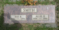
Allie Dell Morrison Smith
| Birth | : | 25 Mar 1898 Thorp, Kittitas County, Washington, USA |
| Death | : | 21 Aug 1986 Ellensburg, Kittitas County, Washington, USA |
| Burial | : | Hope Lutheran Cemetery, Delmont, Douglas County, USA |
| Coordinate | : | 43.2821999, -98.1568985 |
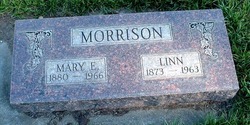
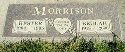
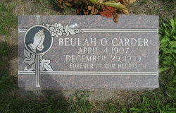
| Description | : | OBIT: Allie D. Smith, 91, 385 W. Seventh Avenue, died Thursday at her home following an extended illness. She was born on Thorp Prairie on March 25, 1898, a daughter of Lynn and Mary (Mattox) Morrison. Mrs. Smith was a member of the New Testament Christian Church and Royal Neighbors. She and Ray Smith were married in Ellensburg on November 15, 1916. Survivors, in addition to her husband, include one daughter, Mrs. Don (Donna Rae) Leavitt, of Molalla, Oregon; four grandchildren; six great grandchildren; a brother, Kester Morrison of Thorp, and a sister, Beulah Carder, of Ellensburg. She was preceded in death... Read More |
frequently asked questions (FAQ):
-
Where is Allie Dell Morrison Smith's memorial?
Allie Dell Morrison Smith's memorial is located at: Hope Lutheran Cemetery, Delmont, Douglas County, USA.
-
When did Allie Dell Morrison Smith death?
Allie Dell Morrison Smith death on 21 Aug 1986 in Ellensburg, Kittitas County, Washington, USA
-
Where are the coordinates of the Allie Dell Morrison Smith's memorial?
Latitude: 43.2821999
Longitude: -98.1568985
Family Members:
Parent

Spouse

Siblings
Flowers:


Nearby Cemetories:
1. Hope Lutheran Cemetery
Delmont, Douglas County, USA
Coordinate: 43.2821999, -98.1568985
2. Zion Lutheran Cemetery
Delmont, Douglas County, USA
Coordinate: 43.2822000, -98.1558000
3. Delmont Cemetery
Delmont, Douglas County, USA
Coordinate: 43.2757988, -98.1481018
4. Old Missouri Cemetery
Delmont, Douglas County, USA
Coordinate: 43.2947006, -98.2043991
5. Emmanuel Lutheran Cemetery
Delmont, Douglas County, USA
Coordinate: 43.3331200, -98.1885800
6. Neusatz Cemetery
Douglas County, USA
Coordinate: 43.3410988, -98.1643982
7. Hoffnungsberg Cemetery
Hutchinson County, USA
Coordinate: 43.2972600, -98.0485700
8. Saint Marys Cemetery
Douglas County, USA
Coordinate: 43.3703000, -98.1119000
9. Oak Hollow Cemetery
Hutchinson County, USA
Coordinate: 43.1963997, -98.0599976
10. Zion Baptist Church Cemetery
Wagner, Charles Mix County, USA
Coordinate: 43.1761400, -98.2085800
11. Congregational Church Cemetery
Charles Mix County, USA
Coordinate: 43.1695600, -98.1834300
12. Haffner Family Farm Cemetery
Hutchinson County, USA
Coordinate: 43.2134840, -98.0312720
13. Eigenfeld Evangelical Lutheran Cemetery
Hutchinson County, USA
Coordinate: 43.3549995, -98.0335999
14. New Salem Reformed Cemetery
Charles Mix County, USA
Coordinate: 43.1683006, -98.1271973
15. Saint Pauls Lutheran Cemetery
Charles Mix County, USA
Coordinate: 43.1642780, -98.1687250
16. Saint Peters Cemetery
Douglas County, USA
Coordinate: 43.3847008, -98.2514038
17. Evangelic Cemetery
Douglas County, USA
Coordinate: 43.4124985, -98.1318970
18. Zion Cemetery
Parkston, Hutchinson County, USA
Coordinate: 43.3448100, -97.9939900
19. Pleasant Ridge Cemetery
Armour, Douglas County, USA
Coordinate: 43.3250008, -98.3386002
20. Roberts Chapel Cemetery
Douglas County, USA
Coordinate: 43.4127998, -98.2225037
21. Pietz Cemetery
Hutchinson County, USA
Coordinate: 43.2703018, -97.9599991
22. Zion Lutheran Cemetery
Tripp, Hutchinson County, USA
Coordinate: 43.1974400, -97.9917300
23. Friedens Reformed Cemetery
Tripp, Hutchinson County, USA
Coordinate: 43.2113991, -97.9657974
24. Grace Hill Cemetery
Tripp, Hutchinson County, USA
Coordinate: 43.2111015, -97.9638977