

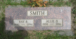
Raymond Randle Smith
| Birth | : | 23 Jun 1895 Minnesota, USA |
| Death | : | 29 Jan 1994 Marion County, Oregon, USA |
| Burial | : | Hope Lutheran Cemetery, Delmont, Douglas County, USA |
| Coordinate | : | 43.2821999, -98.1568985 |
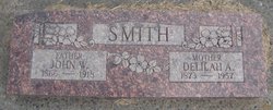
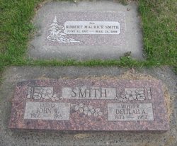
| Description | : | OBIT: Raymond (Ray) Randall Smith, 98, formerly of Ellensburg, died at the Marion Retirement Center in Sublimity, Oregon, on January 29, 1994. He moved to Oregon in 1988 to be near his daughter, Donna Rae Leavitt. Mr. Smith was born June 23, 1895 in Joy, Minnesota, to John and Delilah (Melugin) Smith. In 1912, traveling by rail, his family moved to Thorp. While his mother supervised the younger children in the passenger coach, Ray and his father cared for the horses and cattle in the livestock cars. On November 15, 1916, he married Allie Dell Morrison, daughter of Linn and... Read More |
frequently asked questions (FAQ):
-
Where is Raymond Randle Smith's memorial?
Raymond Randle Smith's memorial is located at: Hope Lutheran Cemetery, Delmont, Douglas County, USA.
-
When did Raymond Randle Smith death?
Raymond Randle Smith death on 29 Jan 1994 in Marion County, Oregon, USA
-
Where are the coordinates of the Raymond Randle Smith's memorial?
Latitude: 43.2821999
Longitude: -98.1568985
Family Members:
Parent

Spouse
Siblings

Flowers:


Nearby Cemetories:
1. Hope Lutheran Cemetery
Delmont, Douglas County, USA
Coordinate: 43.2821999, -98.1568985
2. Zion Lutheran Cemetery
Delmont, Douglas County, USA
Coordinate: 43.2822000, -98.1558000
3. Delmont Cemetery
Delmont, Douglas County, USA
Coordinate: 43.2757988, -98.1481018
4. Old Missouri Cemetery
Delmont, Douglas County, USA
Coordinate: 43.2947006, -98.2043991
5. Emmanuel Lutheran Cemetery
Delmont, Douglas County, USA
Coordinate: 43.3331200, -98.1885800
6. Neusatz Cemetery
Douglas County, USA
Coordinate: 43.3410988, -98.1643982
7. Hoffnungsberg Cemetery
Hutchinson County, USA
Coordinate: 43.2972600, -98.0485700
8. Saint Marys Cemetery
Douglas County, USA
Coordinate: 43.3703000, -98.1119000
9. Oak Hollow Cemetery
Hutchinson County, USA
Coordinate: 43.1963997, -98.0599976
10. Zion Baptist Church Cemetery
Wagner, Charles Mix County, USA
Coordinate: 43.1761400, -98.2085800
11. Congregational Church Cemetery
Charles Mix County, USA
Coordinate: 43.1695600, -98.1834300
12. Haffner Family Farm Cemetery
Hutchinson County, USA
Coordinate: 43.2134840, -98.0312720
13. Eigenfeld Evangelical Lutheran Cemetery
Hutchinson County, USA
Coordinate: 43.3549995, -98.0335999
14. New Salem Reformed Cemetery
Charles Mix County, USA
Coordinate: 43.1683006, -98.1271973
15. Saint Pauls Lutheran Cemetery
Charles Mix County, USA
Coordinate: 43.1642780, -98.1687250
16. Saint Peters Cemetery
Douglas County, USA
Coordinate: 43.3847008, -98.2514038
17. Evangelic Cemetery
Douglas County, USA
Coordinate: 43.4124985, -98.1318970
18. Zion Cemetery
Parkston, Hutchinson County, USA
Coordinate: 43.3448100, -97.9939900
19. Pleasant Ridge Cemetery
Armour, Douglas County, USA
Coordinate: 43.3250008, -98.3386002
20. Roberts Chapel Cemetery
Douglas County, USA
Coordinate: 43.4127998, -98.2225037
21. Pietz Cemetery
Hutchinson County, USA
Coordinate: 43.2703018, -97.9599991
22. Zion Lutheran Cemetery
Tripp, Hutchinson County, USA
Coordinate: 43.1974400, -97.9917300
23. Friedens Reformed Cemetery
Tripp, Hutchinson County, USA
Coordinate: 43.2113991, -97.9657974
24. Grace Hill Cemetery
Tripp, Hutchinson County, USA
Coordinate: 43.2111015, -97.9638977