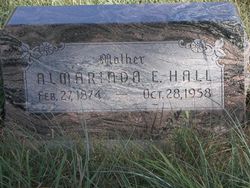
Almarinda Ellen Griffith Hall
| Birth | : | 27 Feb 1874 Dalton, Randolph County, Arkansas, USA |
| Death | : | 28 Oct 1958 Sargent, Custer County, Nebraska, USA |
| Burial | : | Clark Cemetery, Rochester, Strafford County, USA |
| Coordinate | : | 43.3009850, -71.0074390 |
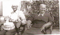
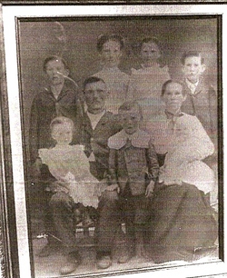
| Description | : | Sargent, Nebraska--Mrs. Almarinda Hall, 84, died at the Community hospital Tuesday following a three-weeks-illness. Services will be held at the EUB Church in Taylor at 2:00 P.M. Friday. Burial will be at the Moulton cemetery, Almeria. Spooner-Rhoad Funeral Home is in charge of arrangments. She was born in Dalton, Arkansas, February 27, 1874, to Mr. & Mrs. Smith Griffith. In 1890 she married Joseph Allen Hall and they lived in Arkansas, Missouri, and Iowa. In 1926 she and her husband moved to Loup County. Later, they moved to Southeastern Nebraska, and Mr. Hall died there... Read More |
frequently asked questions (FAQ):
-
Where is Almarinda Ellen Griffith Hall's memorial?
Almarinda Ellen Griffith Hall's memorial is located at: Clark Cemetery, Rochester, Strafford County, USA.
-
When did Almarinda Ellen Griffith Hall death?
Almarinda Ellen Griffith Hall death on 28 Oct 1958 in Sargent, Custer County, Nebraska, USA
-
Where are the coordinates of the Almarinda Ellen Griffith Hall's memorial?
Latitude: 43.3009850
Longitude: -71.0074390
Family Members:
Parent
Spouse
Siblings
Children
Flowers:
Nearby Cemetories:
1. Clark Cemetery
Rochester, Strafford County, USA
Coordinate: 43.3009850, -71.0074390
2. Furber Cemetery
Rochester, Strafford County, USA
Coordinate: 43.3026000, -71.0077000
3. French-Hussey Family Burial Ground
Rochester, Strafford County, USA
Coordinate: 43.2979400, -70.9918980
4. Brewster Farm Cemetery
Rochester, Strafford County, USA
Coordinate: 43.2958330, -70.9908330
5. Old Town Cemetery
Rochester, Strafford County, USA
Coordinate: 43.3095200, -70.9913500
6. Foss Cemetery
Rochester, Strafford County, USA
Coordinate: 43.2844800, -71.0113800
7. Holy Rosary Cemetery
Rochester, Strafford County, USA
Coordinate: 43.2933250, -70.9856770
8. Pearl Cemetery
Rochester, Strafford County, USA
Coordinate: 43.2851610, -71.0293210
9. McDuffee Family Cemetery
Rochester, Strafford County, USA
Coordinate: 43.3241670, -70.9994440
10. Foss Family Cemetery
Rochester, Strafford County, USA
Coordinate: 43.2760360, -71.0156300
11. Howard Cemetery
Rochester, Strafford County, USA
Coordinate: 43.2947120, -71.0437740
12. Old Cemetery
Rochester, Strafford County, USA
Coordinate: 43.2997210, -70.9683750
13. Jenness Family Cemetery
Rochester, Strafford County, USA
Coordinate: 43.3200000, -71.0372220
14. Ham-Clark Cemetery
Gonic, Strafford County, USA
Coordinate: 43.2721260, -70.9952230
15. Gonic Village Cemetery
Gonic, Strafford County, USA
Coordinate: 43.2780420, -70.9797880
16. Rogers Page Cemetery
Rochester, Strafford County, USA
Coordinate: 43.3321800, -71.0067150
17. Saint Marys Cemetery
Rochester, Strafford County, USA
Coordinate: 43.2885160, -70.9666660
18. Rochester Cemetery
Rochester, Strafford County, USA
Coordinate: 43.3022003, -70.9630966
19. Hurd Cemetery
Gonic, Strafford County, USA
Coordinate: 43.2698590, -70.9938210
20. Otis Family Cemetery
Gonic, Strafford County, USA
Coordinate: 43.2692012, -70.9901888
21. Clark-Weeks Cemetery
Barrington, Strafford County, USA
Coordinate: 43.2738890, -71.0380560
22. Kimball Cemetery
Rochester, Strafford County, USA
Coordinate: 43.3116989, -71.0535965
23. Friends Cemetery
Rochester, Strafford County, USA
Coordinate: 43.3133350, -71.0538590
24. Bickford Family Burial Ground #2
Rochester, Strafford County, USA
Coordinate: 43.3347220, -71.0327780

