
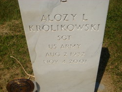
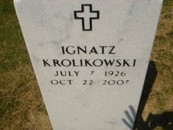
Alozy Laurance Krolikowski
| Birth | : | 2 Aug 1932 Ashton, Sherman County, Nebraska, USA |
| Death | : | 4 Nov 2001 Ashton, Sherman County, Nebraska, USA |
| Burial | : | St Michael and All Angels Churchyard, Fenny Drayton, Hinckley and Bosworth Borough, England |
| Coordinate | : | 52.5707200, -1.4845060 |
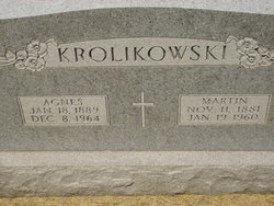
| Description | : | Thanks to contributor #48796369 Alozy L. Krolikowski, 69, of Ashton died Sunday, Nov. 4, 2001, at his home. Services will be at 10:30 a.m. Wednesday at St. Francis Catholic Church in Ashton. The Rev. Larry Coulter will officiate. Burial will be in St. Francis Catholic Cemetery in Ashton with military honors by Ashton American Legion Post 108. Visitation and vigil services were Tuesday at Higgins Funeral Home in Loup City. Mr. Krolikowski was born on Aug. 2, 1932, at Ashton to Martin and Agnes (Tyma) Krolikowski. He attended District 56 School and St. Francis Parochial School. ... Read More |
frequently asked questions (FAQ):
-
Where is Alozy Laurance Krolikowski's memorial?
Alozy Laurance Krolikowski's memorial is located at: St Michael and All Angels Churchyard, Fenny Drayton, Hinckley and Bosworth Borough, England.
-
When did Alozy Laurance Krolikowski death?
Alozy Laurance Krolikowski death on 4 Nov 2001 in Ashton, Sherman County, Nebraska, USA
-
Where are the coordinates of the Alozy Laurance Krolikowski's memorial?
Latitude: 52.5707200
Longitude: -1.4845060
Family Members:
Parent

Siblings
Flowers:


Nearby Cemetories:
1. St Michael and All Angels Churchyard
Fenny Drayton, Hinckley and Bosworth Borough, England
Coordinate: 52.5707200, -1.4845060
2. St. Theobald & St. Chad Churchyard
Caldecote, Nuneaton and Bedworth Borough, England
Coordinate: 52.5528940, -1.4871720
3. St Peter's Churchyard
Witherley, Hinckley and Bosworth Borough, England
Coordinate: 52.5728260, -1.5213970
4. Mancetter Cemetery
Mancetter, North Warwickshire Borough, England
Coordinate: 52.5664850, -1.5273480
5. St Peter Churchyard
Mancetter, North Warwickshire Borough, England
Coordinate: 52.5670920, -1.5285640
6. All Saints Churchyard
Witherley, Hinckley and Bosworth Borough, England
Coordinate: 52.5917330, -1.5190440
7. Friends Meeting House
Hartshill, North Warwickshire Borough, England
Coordinate: 52.5479560, -1.5204940
8. St Peter Churchyard
Higham on the Hill, Hinckley and Bosworth Borough, England
Coordinate: 52.5563500, -1.4373800
9. Saint James' Churchyard
Nuneaton, Nuneaton and Bedworth Borough, England
Coordinate: 52.5387900, -1.4715000
10. St James Churchyard
Weddington, Nuneaton and Bedworth Borough, England
Coordinate: 52.5387160, -1.4711740
11. Saint Botolph Churchyard
Sibson, Hinckley and Bosworth Borough, England
Coordinate: 52.6048360, -1.4784520
12. Hartshill Cemetery
Hartshill, North Warwickshire Borough, England
Coordinate: 52.5440860, -1.5225490
13. St Mary's
Atherstone, North Warwickshire Borough, England
Coordinate: 52.5785037, -1.5462105
14. Atherstone Cemetery
Atherstone, North Warwickshire Borough, England
Coordinate: 52.5820170, -1.5474510
15. Congregational Church Burial Ground
Hartshill, North Warwickshire Borough, England
Coordinate: 52.5375900, -1.5227530
16. St. Margaret's Churchyard
Stoke Golding, Hinckley and Bosworth Borough, England
Coordinate: 52.5718310, -1.4143620
17. St John The Evangelist Churchyard
Sutton Cheney, Hinckley and Bosworth Borough, England
Coordinate: 52.5993750, -1.4304870
18. Saint John the Evangelist Churchyard
Nuneaton and Bedworth Borough, England
Coordinate: 52.5994360, -1.4305740
19. Bucks Hill Cemetery
Stockingford, Nuneaton and Bedworth Borough, England
Coordinate: 52.5317650, -1.5175750
20. All Saints Churchyard
Sheepy, Hinckley and Bosworth Borough, England
Coordinate: 52.6090220, -1.5208910
21. Stoke Golding Cemetery
Stoke Golding, Hinckley and Bosworth Borough, England
Coordinate: 52.5702800, -1.4115900
22. Abbey Church
Nuneaton, Nuneaton and Bedworth Borough, England
Coordinate: 52.5256800, -1.4770800
23. St James Churchyard
Dadlington, Hinckley and Bosworth Borough, England
Coordinate: 52.5789330, -1.4059080
24. Oaston Road Cemetery
Nuneaton, Nuneaton and Bedworth Borough, England
Coordinate: 52.5244040, -1.4574020