
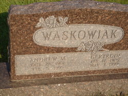
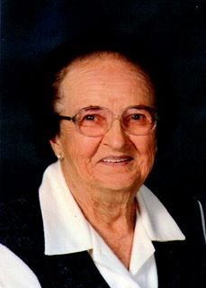
Gertrude Krolikowski Waskowiak
| Birth | : | 17 Feb 1909 Howard County, Nebraska, USA |
| Death | : | 3 May 1999 Saint Paul, Howard County, Nebraska, USA |
| Burial | : | Cheshunt Cemetery, Cheshunt, Broxbourne Borough, England |
| Coordinate | : | 51.7009840, -0.0563720 |
| Description | : | Thanks to contributor #48796369. Gertrude Waskowiak, 90, of St. Paul, formerly of Loup City, died Monday, May 3, 1999, at Heritage Living Center in St. Paul. Services will be at 10 a.m. Friday at St. Josaphat's Catholic Church in Loup City. The Revs. Reginald A. Urban and Michael McDermott will officiate. Burial will be in St. Francis Catholic Cemetery at Ashton. Visitation will be from 3 to 5 and 6 to 8 p.m. Thursday at the church with a sodality rosary at 4 p.m. and a vigil service at 7 p.m. Peters Funeral Home of Loup City is... Read More |
frequently asked questions (FAQ):
-
Where is Gertrude Krolikowski Waskowiak's memorial?
Gertrude Krolikowski Waskowiak's memorial is located at: Cheshunt Cemetery, Cheshunt, Broxbourne Borough, England.
-
When did Gertrude Krolikowski Waskowiak death?
Gertrude Krolikowski Waskowiak death on 3 May 1999 in Saint Paul, Howard County, Nebraska, USA
-
Where are the coordinates of the Gertrude Krolikowski Waskowiak's memorial?
Latitude: 51.7009840
Longitude: -0.0563720
Family Members:
Parent

Spouse

Siblings
Children


Flowers:


Nearby Cemetories:
1. Cheshunt Cemetery
Cheshunt, Broxbourne Borough, England
Coordinate: 51.7009840, -0.0563720
2. St Mary the Virgin Church
Cheshunt, Broxbourne Borough, England
Coordinate: 51.7042420, -0.0489450
3. Adath Yisroel Cemetery
Cheshunt, Broxbourne Borough, England
Coordinate: 51.7015690, -0.0772910
4. Western Synagogue Cemetery
Cheshunt, Broxbourne Borough, England
Coordinate: 51.6850350, -0.0615410
5. St George Churchyard
Freezywater, London Borough of Enfield, England
Coordinate: 51.6738060, -0.0389670
6. Enfield Crematorium
Enfield, London Borough of Enfield, England
Coordinate: 51.6699829, -0.0544380
7. Waltham Abbey
Waltham Abbey, Epping Forest District, England
Coordinate: 51.6876010, -0.0034070
8. St. Laurence Churchyard
Wormley, Broxbourne Borough, England
Coordinate: 51.7352050, -0.0389350
9. Adath Yisroel Cemetery
Enfield, London Borough of Enfield, England
Coordinate: 51.6634740, -0.0669010
10. Waltham Holy Cross-New Cemetery
Waltham Abbey, Epping Forest District, England
Coordinate: 51.6822880, 0.0024510
11. Waltham Holy Cross Old Cemetery
Waltham Abbey, Epping Forest District, England
Coordinate: 51.6823480, 0.0027610
12. Lavender Hill Cemetery
Enfield, London Borough of Enfield, England
Coordinate: 51.6660423, -0.0944350
13. St. James' Churchyard
Enfield, London Borough of Enfield, England
Coordinate: 51.6558850, -0.0470570
14. Hertford Road Cemetery
Enfield, London Borough of Enfield, England
Coordinate: 51.6554120, -0.0449750
15. St Andrew Churchyard
Enfield, London Borough of Enfield, England
Coordinate: 51.6530210, -0.0821420
16. Saint Augustine's Churchyard
Broxbourne, Broxbourne Borough, England
Coordinate: 51.7445150, -0.0147810
17. Waltham Abbey Jewish Cemetery
Waltham Abbey, Epping Forest District, England
Coordinate: 51.6778780, 0.0389240
18. St. Thomas Churchyard
Upshire, Epping Forest District, England
Coordinate: 51.6898890, 0.0465860
19. Quaker Burial Ground, Hoddesdon, Hertfordshire
Hoddesdon, Broxbourne Borough, England
Coordinate: 51.7610213, -0.0139560
20. St Catherine and St Paul's Churchyard
Hoddesdon, Broxbourne Borough, England
Coordinate: 51.7625830, -0.0120670
21. Saint Mary
Bayford, East Hertfordshire District, England
Coordinate: 51.7629540, -0.1035070
22. Holy Innocents Churchyard
High Beach, Epping Forest District, England
Coordinate: 51.6617140, 0.0343380
23. Woollensbrook Crematorium
Hoddesdon, Broxbourne Borough, England
Coordinate: 51.7681805, -0.0280669
24. St. Andrew's Churchyard
Little Berkhamsted, East Hertfordshire District, England
Coordinate: 51.7547390, -0.1295270