
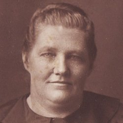
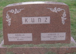

Amalia “Mollie” Lee Kunz
| Birth | : | 18 Apr 1873 |
| Death | : | 2 Jul 1943 |
| Burial | : | Church of the Ascension, Oughtibridge, Metropolitan Borough of Sheffield, England |
| Coordinate | : | 53.4349330, -1.5422590 |
frequently asked questions (FAQ):
-
Where is Amalia “Mollie” Lee Kunz's memorial?
Amalia “Mollie” Lee Kunz's memorial is located at: Church of the Ascension, Oughtibridge, Metropolitan Borough of Sheffield, England.
-
When did Amalia “Mollie” Lee Kunz death?
Amalia “Mollie” Lee Kunz death on 2 Jul 1943 in
-
Where are the coordinates of the Amalia “Mollie” Lee Kunz's memorial?
Latitude: 53.4349330
Longitude: -1.5422590
Family Members:
Parent
Spouse
Siblings
Children
Flowers:


Nearby Cemetories:
1. Church of the Ascension
Oughtibridge, Metropolitan Borough of Sheffield, England
Coordinate: 53.4349330, -1.5422590
2. Birtin Cemetery
Oughtibridge, Metropolitan Borough of Sheffield, England
Coordinate: 53.4295900, -1.5485600
3. Grenoside Crematorium
Grenoside, Metropolitan Borough of Sheffield, England
Coordinate: 53.4375860, -1.5087020
4. Wadsley Churchyard
Sheffield, Metropolitan Borough of Sheffield, England
Coordinate: 53.4120290, -1.5181790
5. Loxley United Reformed Chapelyard
Sheffield, Metropolitan Borough of Sheffield, England
Coordinate: 53.4074490, -1.5459890
6. Loxley United Reformed Church
Bradfield, Metropolitan Borough of Sheffield, England
Coordinate: 53.4074084, -1.5456459
7. Wisewood Cemetery
Sheffield, Metropolitan Borough of Sheffield, England
Coordinate: 53.4038050, -1.5401300
8. Saint Nicholas Churchyard
High Bradfield, Metropolitan Borough of Sheffield, England
Coordinate: 53.4291200, -1.5991120
9. Hillsborough Walled Garden Memorials
Hillsborough, Metropolitan Borough of Sheffield, England
Coordinate: 53.4071221, -1.5039054
10. Wardsend Cemetery
Sheffield, Metropolitan Borough of Sheffield, England
Coordinate: 53.4086120, -1.4895330
11. Stannington Methodist Churchyard
Stannington, Metropolitan Borough of Sheffield, England
Coordinate: 53.3939340, -1.5454460
12. Underbank Unitarian Chapel
High Bradfield, Metropolitan Borough of Sheffield, England
Coordinate: 53.3942504, -1.5554100
13. Stannington Unitarian Chapel
Stannington, Metropolitan Borough of Sheffield, England
Coordinate: 53.3941350, -1.5556060
14. Hillsborough Barracks Chapel Courtyard
Hillsborough, Metropolitan Borough of Sheffield, England
Coordinate: 53.4013100, -1.4980900
15. Ecclesfield Cemetery
Ecclesfield, Metropolitan Borough of Sheffield, England
Coordinate: 53.4441210, -1.4719340
16. Christ Church Churchyard
Stannington, Metropolitan Borough of Sheffield, England
Coordinate: 53.3918830, -1.5469320
17. St. Paul's Churchyard
Sheffield, Metropolitan Borough of Sheffield, England
Coordinate: 53.4333670, -1.4692500
18. St. Mary the Virgin Churchyard
Ecclesfield, Metropolitan Borough of Sheffield, England
Coordinate: 53.4432350, -1.4698510
19. St. Mary's Churchyard
Bolsterstone, Metropolitan Borough of Sheffield, England
Coordinate: 53.4673770, -1.5935860
20. St Michael's Roman Catholic Cemetery
Sheffield, Metropolitan Borough of Sheffield, England
Coordinate: 53.3916300, -1.5162800
21. Rivelin Jewish Cemetery
Sheffield, Metropolitan Borough of Sheffield, England
Coordinate: 53.3914480, -1.5149920
22. Burncross Cemetery
Burncross, Metropolitan Borough of Sheffield, England
Coordinate: 53.4631420, -1.4796780
23. Ecclesfield Jewish Cemetery
Ecclesfield, Metropolitan Borough of Sheffield, England
Coordinate: 53.4299600, -1.4637700
24. St Mary Churchyard
Walkley, Metropolitan Borough of Sheffield, England
Coordinate: 53.3907127, -1.5148580