
| Birth | : | 9 Jan 1852 Hendricks County, Indiana, USA |
| Death | : | 12 Jul 1935 Omaha, Douglas County, Nebraska, USA |
| Burial | : | Olivet Memorial Park, Colma, San Mateo County, USA |
| Coordinate | : | 37.6818040, -122.4544450 |
| Plot | : | Lot 16 |
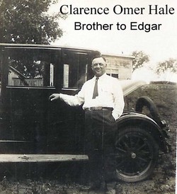
| Description | : | Mrs. Will Jones Dies in Accident - Automobile Collision is Fatal to Aged Bertha Woman A fatal accident occurred near the Bertha store last Wednesday evening when the cars driven by Earl Hale and Wilson Potter collided. Mr. Potter and Gerald McKenzie, who was riding with him, escaped injuries. With Mr. Hale were his wife and two sons, who were badly bruised and cut, and his grandmother, Mrs. Will Jones, who received a crushed chest, a pierced lung and other internal injuries. She was rushed to the Immanuel hospital in Omaha where she passed away Friday morning. Mrs. Jones was a... Read More |
frequently asked questions (FAQ):
-
Where is Amanda Catherine “Kate” Buzzard Hale's memorial?
Amanda Catherine “Kate” Buzzard Hale's memorial is located at: Olivet Memorial Park, Colma, San Mateo County, USA.
-
When did Amanda Catherine “Kate” Buzzard Hale death?
Amanda Catherine “Kate” Buzzard Hale death on 12 Jul 1935 in Omaha, Douglas County, Nebraska, USA
-
Where are the coordinates of the Amanda Catherine “Kate” Buzzard Hale's memorial?
Latitude: 37.6818040
Longitude: -122.4544450
Family Members:
Parent
Spouse

Siblings
Children
Flowers:


Nearby Cemetories:
1. Olivet Memorial Park
Colma, San Mateo County, USA
Coordinate: 37.6818040, -122.4544450
2. Sunset View Cemetery
Colma, San Mateo County, USA
Coordinate: 37.6809578, -122.4527359
3. Japanese Cemetery
Colma, San Mateo County, USA
Coordinate: 37.6837006, -122.4578857
4. The Italian Cemetery
Colma, San Mateo County, USA
Coordinate: 37.6823340, -122.4595360
5. Serbian Cemetery
Colma, San Mateo County, USA
Coordinate: 37.6793556, -122.4500198
6. Pets Rest Cemetery
Colma, San Mateo County, USA
Coordinate: 37.6789398, -122.4493027
7. Eternal Home Cemetery
Colma, San Mateo County, USA
Coordinate: 37.6791060, -122.4601660
8. Hills of Eternity Memorial Park
Colma, San Mateo County, USA
Coordinate: 37.6763992, -122.4540024
9. Salem Memorial Park and Garden
Colma, San Mateo County, USA
Coordinate: 37.6774864, -122.4588470
10. Home of Peace Cemetery and Emanu-El Mausoleum
Colma, San Mateo County, USA
Coordinate: 37.6755829, -122.4552231
11. Greek Orthodox Memorial Park
Colma, San Mateo County, USA
Coordinate: 37.6776314, -122.4611053
12. Golden Hill Memorial Park
Colma, San Mateo County, USA
Coordinate: 37.6778946, -122.4471741
13. Woodlawn Memorial Park
Colma, San Mateo County, USA
Coordinate: 37.6811500, -122.4640470
14. Hoy Sun Memorial Cemetery
Colma, San Mateo County, USA
Coordinate: 37.6772820, -122.4461460
15. Greenlawn Memorial Park
Colma, San Mateo County, USA
Coordinate: 37.6773338, -122.4632797
16. Cypress Lawn Memorial Park
Colma, San Mateo County, USA
Coordinate: 37.6735001, -122.4551926
17. Holy Cross Catholic Cemetery
Colma, San Mateo County, USA
Coordinate: 37.6697006, -122.4464035
18. Hoy Sun Ning Yung Cemetery
Daly City, San Mateo County, USA
Coordinate: 37.6670070, -122.4606940
19. Chinese Christian Cemetery
Daly City, San Mateo County, USA
Coordinate: 37.6675490, -122.4633350
20. Russian Sectarian Cemetery
Colma, San Mateo County, USA
Coordinate: 37.6669940, -122.4624480
21. Chong Seen Tong Cemetery
Daly City, San Mateo County, USA
Coordinate: 37.6664800, -122.4613600
22. Tung Sen Cemetery
Daly City, San Mateo County, USA
Coordinate: 37.6661660, -122.4620250
23. Chinese Cemetery
Daly City, San Mateo County, USA
Coordinate: 37.6674652, -122.4746628
24. Orange Memorial Park (Defunct)
South San Francisco, San Mateo County, USA
Coordinate: 37.6542015, -122.4257965