
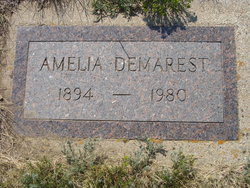
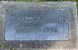
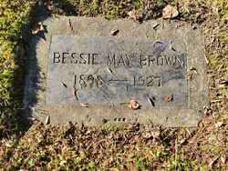
Amelia B. Brown Demarest
| Birth | : | 2 Dec 1894 Great Falls, Cascade County, Montana, USA |
| Death | : | 9 Jan 1980 Shelby, Toole County, Montana, USA |
| Burial | : | Whitlash Cemetery, Liberty County, USA |
| Coordinate | : | 48.9085999, -111.2699966 |
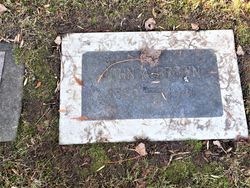
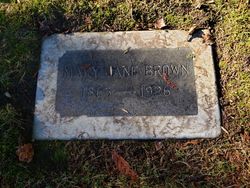
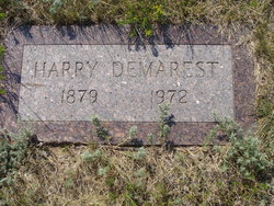
| Description | : | Liberty County Times, Chester, MT, Jan. 18 1920 (excerpt) Amelia B. Demarest, 85, died Wednesday, Jan. 9, at the Toole County Memorial Hospital. Born in Great Falls, Dec. 2, 1894, she grew up in the Sweetgrass Hills. She married Harry S. Demarest in 1911 at the home of her parents John and Mary Jane Brown. They ranched in the Sweetgrass Hills their entire lives. Mrs. Demarest was a lifetime member of the National and local CowBelles Association and a charter member of the Whitlash Presbyterian Church. She was active in the local republican clubs, the home demonstration club,... Read More |
frequently asked questions (FAQ):
-
Where is Amelia B. Brown Demarest's memorial?
Amelia B. Brown Demarest's memorial is located at: Whitlash Cemetery, Liberty County, USA.
-
When did Amelia B. Brown Demarest death?
Amelia B. Brown Demarest death on 9 Jan 1980 in Shelby, Toole County, Montana, USA
-
Where are the coordinates of the Amelia B. Brown Demarest's memorial?
Latitude: 48.9085999
Longitude: -111.2699966
Family Members:
Parent
Spouse
Siblings
Children

Flowers:


Nearby Cemetories:
1. Whitlash Cemetery
Liberty County, USA
Coordinate: 48.9085999, -111.2699966
2. Old Indian Cemetery
Liberty County, USA
Coordinate: 48.8680992, -111.2585983
3. Gold Butte Cemetery
Toole County, USA
Coordinate: 48.8793983, -111.3966980
4. Sunnyside Cemetery
Aden, Medicine Hat Census Division, Canada
Coordinate: 49.0286300, -111.3240800
5. Trinity Church Cemetery
Lothair, Liberty County, USA
Coordinate: 48.7263000, -111.2296000
6. Grandview Cemetery
Toole County, USA
Coordinate: 48.7265000, -111.3615000
7. Sage Creek Colony Cemetery
Sage Creek Colony, Liberty County, USA
Coordinate: 48.9271000, -110.9735000
8. Eagle Creek Colony Cemetery
Chester, Liberty County, USA
Coordinate: 48.6976000, -111.2011000
9. Nutter Ranch Cemetery
Sunburst, Toole County, USA
Coordinate: 48.9668200, -111.6365320
10. Masinasin Cemetery
Milk River, Lethbridge Census Division, Canada
Coordinate: 49.1302328, -111.6527199
11. Sacred Heart Cemetery
Foremost, Medicine Hat Census Division, Canada
Coordinate: 49.2646570, -111.1999957
12. Prairie Round Cemetery
Lucky Strike, Lethbridge Census Division, Canada
Coordinate: 49.2249600, -111.5523800
13. Sunburst Cemetery
Sunburst, Toole County, USA
Coordinate: 48.8847800, -111.8743800
14. Allerston Cemetery
Milk River, Lethbridge Census Division, Canada
Coordinate: 49.1451500, -111.7664000
15. Pendant d'Oreille Cemetery
Manyberries, Medicine Hat Census Division, Canada
Coordinate: 49.2202530, -110.8806230
16. Burlington Cemetery
Nemiskam, Medicine Hat Census Division, Canada
Coordinate: 49.3115100, -111.3515200
17. Comrey Cemetery
Manyberries, Medicine Hat Census Division, Canada
Coordinate: 49.1204000, -110.7179700
18. Chester Cemetery
Chester, Liberty County, USA
Coordinate: 48.5219002, -110.9807968
19. Grace Church Cemetery
Rudyard, Hill County, USA
Coordinate: 48.8269930, -110.6209890
20. Lothair Protestant Cemetery
Lothair, Liberty County, USA
Coordinate: 48.4694000, -111.2393100
21. Lothair Catholic Cemetery
Lothair, Liberty County, USA
Coordinate: 48.4687000, -111.2484000
22. Galata Cemetery
Toole County, USA
Coordinate: 48.4655991, -111.3349991
23. Devon Cemetery
Toole County, USA
Coordinate: 48.4693000, -111.4713000
24. Coutts Cemetery
Coutts, Lethbridge Census Division, Canada
Coordinate: 48.9989690, -111.9647810