
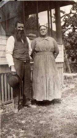
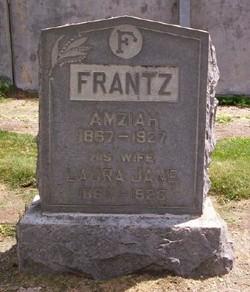

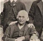
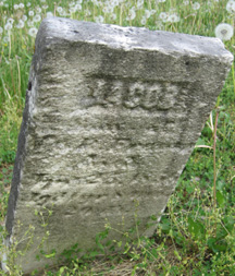
Amziah Frantz
| Birth | : | 1867 |
| Death | : | 21 May 1927 |
| Burial | : | St. Peter's Churchyard, Newton-le-Willows, Metropolitan Borough of St Helens, England |
| Coordinate | : | 53.4559330, -2.6143730 |
| Plot | : | Row-1-S11-3 |
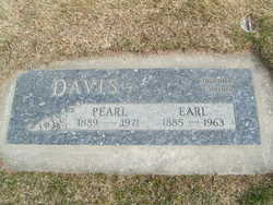
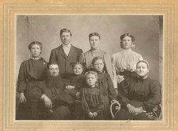
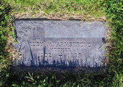
| Description | : | Wenatchee Daily World May 23, 1927 Amziah F. Frantz of 534 Malaga Street, passed away at his home at 7:30 o'clock Saturday evening at the age of 60 years, 1 month and 14 days. He is survived by his widow Ethel; one son C.E. Frantz of Waverly, Wash. and six daughters, Mrs. Pearl Davis of Portland, Oregon, Mrs. Bertha Marriott of Maynith, Kansas; Mrs. Clara Meyer of Sioux City, Ia.; Mrs Gerogia Pittman of Manson, Mrs Ruby Armstrong and Mrs. Verna Dull of Wenatchee. The deceased had seven brothers, five of whom reside in North Manchester, Ind. They are: Josiah, Cyrus,... Read More |
frequently asked questions (FAQ):
-
Where is Amziah Frantz's memorial?
Amziah Frantz's memorial is located at: St. Peter's Churchyard, Newton-le-Willows, Metropolitan Borough of St Helens, England.
-
When did Amziah Frantz death?
Amziah Frantz death on 21 May 1927 in
-
Where are the coordinates of the Amziah Frantz's memorial?
Latitude: 53.4559330
Longitude: -2.6143730
Family Members:
Parent
Spouse

Siblings

Children
Flowers:


Nearby Cemetories:
1. St. Peter's Churchyard
Newton-le-Willows, Metropolitan Borough of St Helens, England
Coordinate: 53.4559330, -2.6143730
2. Newton-le-Willows Cemetery
Newton-le-Willows, Metropolitan Borough of St Helens, England
Coordinate: 53.4471970, -2.6217090
3. St. Mary and St. John RC Churchyard
Newton-le-Willows, Metropolitan Borough of St Helens, England
Coordinate: 53.4559410, -2.6323930
4. Emmanuel Wargrave
Newton-le-Willows, Metropolitan Borough of St Helens, England
Coordinate: 53.4454500, -2.6277060
5. All Saints Roman Catholic Churchyard
Golborne, Metropolitan Borough of Wigan, England
Coordinate: 53.4745130, -2.5991750
6. St. Oswald Churchyard
Winwick, Warrington Unitary Authority, England
Coordinate: 53.4309200, -2.5972200
7. St. Luke's Churchyard
Lowton Common, Metropolitan Borough of Wigan, England
Coordinate: 53.4752100, -2.5805770
8. St James' Churchyard
Haydock, Metropolitan Borough of St Helens, England
Coordinate: 53.4679080, -2.6596350
9. Winwick Hospital Churchyard
Warrington Unitary Authority, England
Coordinate: 53.4265000, -2.6050000
10. St. Thomas' Churchyard
Golborne, Metropolitan Borough of Wigan, England
Coordinate: 53.4837560, -2.5917430
11. St Thomas' Churchyard (Heath Road Extension)
Ashton-In-Makerfield, Metropolitan Borough of Wigan, England
Coordinate: 53.4850470, -2.6345810
12. St Thomas Churchyard
Ashton-In-Makerfield, Metropolitan Borough of Wigan, England
Coordinate: 53.4856362, -2.6402671
13. St. Mary's Parish Churchyard
Lowton St Mary's, Metropolitan Borough of Wigan, England
Coordinate: 53.4763450, -2.5512350
14. St Mark Churchyard
Haydock, Metropolitan Borough of St Helens, England
Coordinate: 53.4658540, -2.6892980
15. Christ Church Churchyard
Warrington, Warrington Unitary Authority, England
Coordinate: 53.4376659, -2.5428132
16. Unitarian Chapel
Croft, Warrington Unitary Authority, England
Coordinate: 53.4345995, -2.5440079
17. St Peter's of Parr Churchyard
Parr, Metropolitan Borough of St Helens, England
Coordinate: 53.4543745, -2.7009772
18. Holy Trinity Churchyard
Ashton-In-Makerfield, Metropolitan Borough of Wigan, England
Coordinate: 53.4989280, -2.6688000
19. St. John the Evangelist Churchyard
Abram, Metropolitan Borough of Wigan, England
Coordinate: 53.5090290, -2.5941470
20. Risley Presbyterian Church Churchyard
Warrington Unitary Authority, England
Coordinate: 53.4322500, -2.5283880
21. Christ Church Graveyard
Padgate, Warrington Unitary Authority, England
Coordinate: 53.4072619, -2.5565873
22. St. Anne and Blessed Dominic Churchyard
St Helens, Metropolitan Borough of St Helens, England
Coordinate: 53.4330960, -2.7083700
23. Newchurch Parish Church
Culcheth, Warrington Unitary Authority, England
Coordinate: 53.4505900, -2.5105500
24. St. Barnabas Churchyard
Warrington Unitary Authority, England
Coordinate: 53.3920038, -2.6121106