
| Memorials | : | 0 |
| Location | : | Croft, Warrington Unitary Authority, England |
| Coordinate | : | 53.4345995, -2.5440079 |
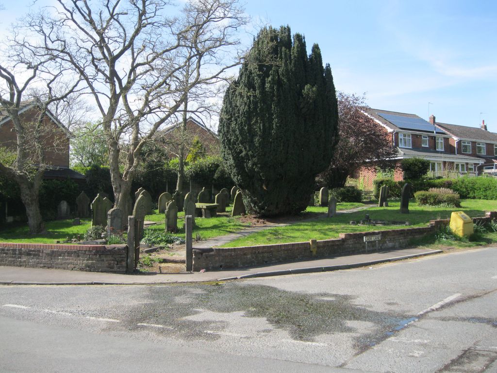
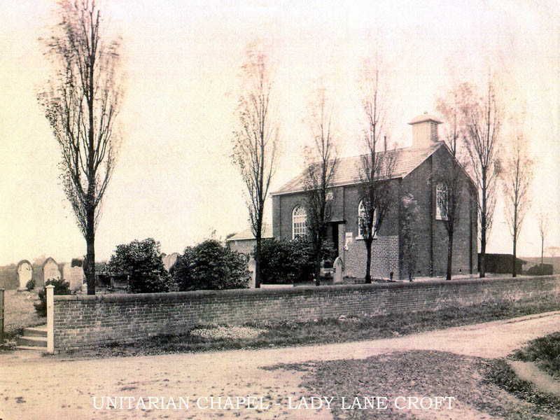
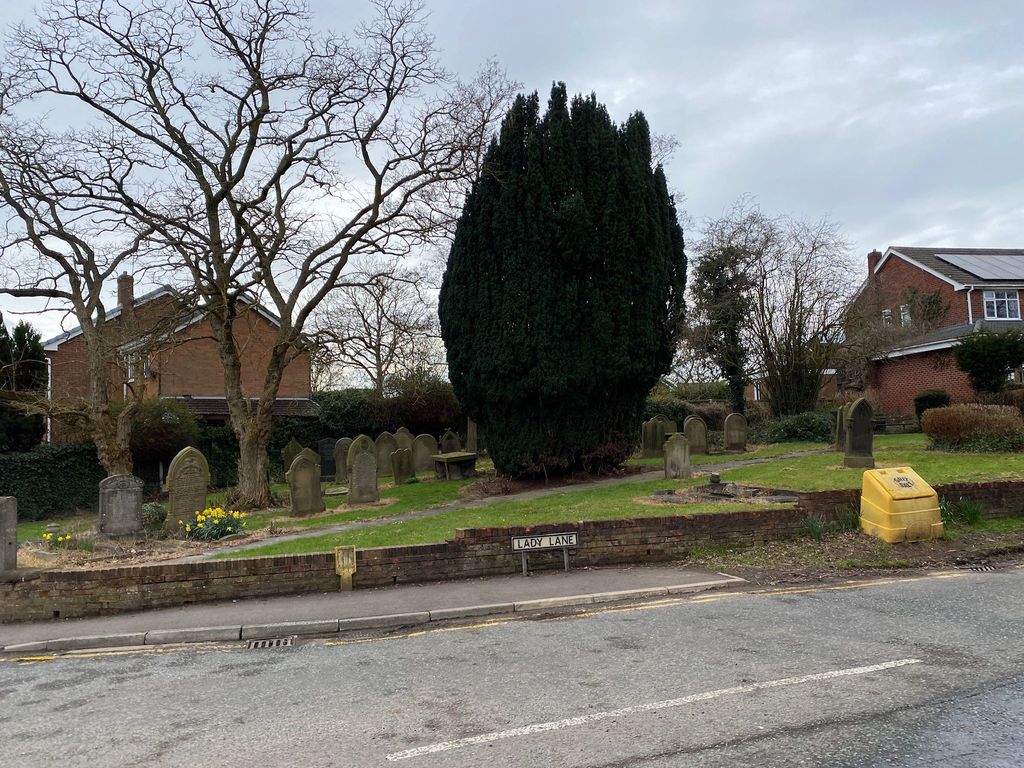
| Description | : | The chapel is shown on the 1849 map as the Unitarian Chapel and was still shown on the 1947 revised map. The building no longer exists but the small graveyard on the corner of Lady Lane and Cross Lane still remains. |
frequently asked questions (FAQ):
-
Where is Unitarian Chapel?
Unitarian Chapel is located at Lady Lane Croft, Warrington Unitary Authority ,Cheshire ,England.
-
Unitarian Chapel cemetery's updated grave count on graveviews.com?
0 memorials
-
Where are the coordinates of the Unitarian Chapel?
Latitude: 53.4345995
Longitude: -2.5440079

Nearby Cemetories:
1. Christ Church Churchyard
Warrington, Warrington Unitary Authority, England
Coordinate: 53.4376659, -2.5428132
2. Risley Presbyterian Church Churchyard
Warrington Unitary Authority, England
Coordinate: 53.4322500, -2.5283880
3. Newchurch Parish Church
Culcheth, Warrington Unitary Authority, England
Coordinate: 53.4505900, -2.5105500
4. Christ Church Graveyard
Padgate, Warrington Unitary Authority, England
Coordinate: 53.4072619, -2.5565873
5. St. Oswald Churchyard
Winwick, Warrington Unitary Authority, England
Coordinate: 53.4309200, -2.5972200
6. Winwick Hospital Churchyard
Warrington Unitary Authority, England
Coordinate: 53.4265000, -2.6050000
7. Warrington Cemetery
Warrington, Warrington Unitary Authority, England
Coordinate: 53.3964660, -2.5730780
8. St. Mary's Parish Churchyard
Lowton St Mary's, Metropolitan Borough of Wigan, England
Coordinate: 53.4763450, -2.5512350
9. All Saints Churchyard
Glazebury, Warrington Unitary Authority, England
Coordinate: 53.4698200, -2.4951800
10. St. Luke's Churchyard
Lowton Common, Metropolitan Borough of Wigan, England
Coordinate: 53.4752100, -2.5805770
11. St. Peter's Churchyard
Newton-le-Willows, Metropolitan Borough of St Helens, England
Coordinate: 53.4559330, -2.6143730
12. Newton-le-Willows Cemetery
Newton-le-Willows, Metropolitan Borough of St Helens, England
Coordinate: 53.4471970, -2.6217090
13. St. Elphin's Churchyard
Warrington, Warrington Unitary Authority, England
Coordinate: 53.3909750, -2.5800370
14. Emmanuel Wargrave
Newton-le-Willows, Metropolitan Borough of St Helens, England
Coordinate: 53.4454500, -2.6277060
15. All Saints Roman Catholic Churchyard
Golborne, Metropolitan Borough of Wigan, England
Coordinate: 53.4745130, -2.5991750
16. All Saints Churchyard
Thelwall, Warrington Unitary Authority, England
Coordinate: 53.3822300, -2.5282700
17. Hollinfare Cemetery
Rixton with Glazebrook, Warrington Unitary Authority, England
Coordinate: 53.4165900, -2.4575100
18. St. Thomas' Churchyard
Golborne, Metropolitan Borough of Wigan, England
Coordinate: 53.4837560, -2.5917430
19. St. Mary and St. John RC Churchyard
Newton-le-Willows, Metropolitan Borough of St Helens, England
Coordinate: 53.4559410, -2.6323930
20. St. Barnabas Churchyard
Warrington Unitary Authority, England
Coordinate: 53.3920038, -2.6121106
21. Saint Werburgh's Churchyard
Warburton, Metropolitan Borough of Trafford, England
Coordinate: 53.4021610, -2.4572830
22. St Wilfrid's Churchyard
Grappenhall, Warrington Unitary Authority, England
Coordinate: 53.3723000, -2.5434000
23. St Thomas Churchyard
Leigh, Metropolitan Borough of Wigan, England
Coordinate: 53.4948600, -2.5073800
24. St Thomas Churchyard
Stockton Heath, Warrington Unitary Authority, England
Coordinate: 53.3723200, -2.5823800