
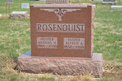
Anders Alfred Andersson Rosenquist
| Birth | : | 20 May 1857 Dalhem, Västerviks kommun, Kalmar län, Sweden |
| Death | : | 22 Apr 1946 Burnside, Webster County, Iowa, USA |
| Burial | : | Dayton Cemetery, Dayton, Webster County, USA |
| Coordinate | : | 42.2675000, -94.0755000 |
| Plot | : | Section 3 |
| Description | : | Dayton Review April 25, 1946 ALFRED ROSENQUIST OF BURNSIDE PASSED AWAY FUNERAL SERVICES ON WEDNESDAY AFTERNOON Alfred Rosenquist, 88, died Monday evening at 9:20 at the home of his son, Arnold, near Burnside, following a short illness. Funeral services were held at 1:30 at the Reuben Rosenquist home near Burnside and at 2 o'clock at the Burnside Lutheran church Wednesday. The Rev. C.A. Benander, pastor of the church will officiate and burial will be in the Dayton cemetery. The Swanson funeral home of Dayton is in charge of funeral arrangements. Born at Kalmar Län, Sweden,... Read More |
frequently asked questions (FAQ):
-
Where is Anders Alfred Andersson Rosenquist's memorial?
Anders Alfred Andersson Rosenquist's memorial is located at: Dayton Cemetery, Dayton, Webster County, USA.
-
When did Anders Alfred Andersson Rosenquist death?
Anders Alfred Andersson Rosenquist death on 22 Apr 1946 in Burnside, Webster County, Iowa, USA
-
Where are the coordinates of the Anders Alfred Andersson Rosenquist's memorial?
Latitude: 42.2675000
Longitude: -94.0755000
Family Members:
Spouse

Children

Flowers:


Nearby Cemetories:
1. Dayton Cemetery
Dayton, Webster County, USA
Coordinate: 42.2675000, -94.0755000
2. Christ the King Catholic Cemetery
Dayton, Webster County, USA
Coordinate: 42.2601929, -94.0727539
3. Bass Cemetery
Dayton, Webster County, USA
Coordinate: 42.2966995, -94.0149994
4. Swedish Lutheran Church Cemetery
Dayton, Webster County, USA
Coordinate: 42.2175000, -94.1065000
5. Oak Grove Cemetery
Lehigh, Webster County, USA
Coordinate: 42.3438988, -94.0475006
6. Hardin Township Cemetery
Hardin Township, Webster County, USA
Coordinate: 42.2411003, -93.9708023
7. Linn Cemetery
Pilot Mound, Boone County, USA
Coordinate: 42.2045330, -93.9970230
8. Lawn Cemetery
Boone County, USA
Coordinate: 42.1771011, -94.0867996
9. West Lawn Cemetery
Lehigh, Webster County, USA
Coordinate: 42.3616982, -94.0678024
10. McGuire Bend Cemetery
Dayton, Webster County, USA
Coordinate: 42.3410000, -93.9880000
11. Runyan Cemetery
Pilot Mound, Boone County, USA
Coordinate: 42.1749992, -94.0015030
12. Pilot Mound Cemetery
Pilot Mound, Boone County, USA
Coordinate: 42.1636200, -94.0282600
13. Vegors Cemetery
Webster County, USA
Coordinate: 42.3177986, -93.9421997
14. Lost Grove Cemetery
Harcourt, Webster County, USA
Coordinate: 42.2583008, -94.2331009
15. Hooks Point Cemetery
Hamilton County, USA
Coordinate: 42.2944530, -93.9199090
16. Oakwood Cemetery
Stratford, Hamilton County, USA
Coordinate: 42.2942009, -93.9182968
17. Hartman Cemetery
Lehigh, Webster County, USA
Coordinate: 42.3666397, -93.9835627
18. White Cemetery
Boone County, USA
Coordinate: 42.1777992, -93.9636002
19. Border Plains Cemetery
Border Plains, Webster County, USA
Coordinate: 42.3917000, -94.0448000
20. Ober and Scott Cemetery
Duncombe, Webster County, USA
Coordinate: 42.3841390, -93.9982856
21. Union Cemetery
Boxholm, Boone County, USA
Coordinate: 42.1369019, -94.0852966
22. Renner Cemetery
Boone County, USA
Coordinate: 42.1380420, -94.1256570
23. Otho Cemetery
Otho, Webster County, USA
Coordinate: 42.4025002, -94.1153030
24. Schlicht Cemetery
Fraser, Boone County, USA
Coordinate: 42.1444200, -93.9780100