

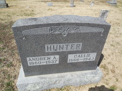
Andrew A Hunter
| Birth | : | 21 Oct 1860 Cole County, Missouri, USA |
| Death | : | 1937 |
| Burial | : | Sunset Memorial Park, Gregson, Silver Bow County, USA |
| Coordinate | : | 46.0596000, -112.7754500 |
| Plot | : | Section 1 |
| Description | : | A.A. Hunter is with the firm of Hunter and Stevens Lumber merchants of Russellville and Centertown. In 1893, he removed to Russellville engaging in the lumber business with his brother-in-law B.R. Stevens. In 1808, they opened a branch office in Centertown . In October 2, 1884 he married Callie,the daughter of J.R. Stevens, and they are both members of the Mt. Olive Baptist Church. In them are united two congenial spirits, who mutually enjoy the comforts of their own home in Russellville. (Directory of Cole County Missouri, 1900) Research by Bonnie Morris Conrad |
frequently asked questions (FAQ):
-
Where is Andrew A Hunter's memorial?
Andrew A Hunter's memorial is located at: Sunset Memorial Park, Gregson, Silver Bow County, USA.
-
When did Andrew A Hunter death?
Andrew A Hunter death on 1937 in
-
Where are the coordinates of the Andrew A Hunter's memorial?
Latitude: 46.0596000
Longitude: -112.7754500
Family Members:
Parent
Spouse
Siblings
Flowers:


Nearby Cemetories:
1. Sunset Memorial Park
Gregson, Silver Bow County, USA
Coordinate: 46.0596000, -112.7754500
2. Norton Cemetery
Anaconda, Deer Lodge County, USA
Coordinate: 46.0619000, -112.8333000
3. Anaconda Catholic Cemetery
Anaconda, Deer Lodge County, USA
Coordinate: 46.1165858, -112.8653042
4. Warm Springs State Hospital Cemetery
Warm Springs, Deer Lodge County, USA
Coordinate: 46.1916580, -112.8032913
5. Lower Hill Cemetery
Anaconda, Deer Lodge County, USA
Coordinate: 46.1213440, -112.9572510
6. Upper Hill Cemetery
Anaconda, Deer Lodge County, USA
Coordinate: 46.1224440, -112.9588340
7. Mount Carmel Cemetery
Anaconda, Deer Lodge County, USA
Coordinate: 46.1237068, -112.9619827
8. Mount Olivet Cemetery
Anaconda, Deer Lodge County, USA
Coordinate: 46.1300011, -112.9739990
9. New Hill Cemetery
Anaconda, Deer Lodge County, USA
Coordinate: 46.1380770, -112.9917530
10. Staffanson Family Cemetery
Anaconda, Deer Lodge County, USA
Coordinate: 46.1780556, -112.9610000
11. Mount Moriah Cemetery
Butte, Silver Bow County, USA
Coordinate: 45.9885500, -112.5423400
12. BNai Israel Cemetery
Butte, Silver Bow County, USA
Coordinate: 45.9865700, -112.5409000
13. Saint Patrick's Cemetery
Butte, Silver Bow County, USA
Coordinate: 45.9844017, -112.5406036
14. Saint Johns Columbarium
Butte, Silver Bow County, USA
Coordinate: 45.9923000, -112.5178000
15. Mountain View Cemetery
Butte, Silver Bow County, USA
Coordinate: 45.9622720, -112.5077200
16. Holy Cross Cemetery
Butte, Silver Bow County, USA
Coordinate: 45.9510994, -112.5036011
17. Potters Field
Butte, Silver Bow County, USA
Coordinate: 45.9894470, -112.4773280
18. Dewey Cemetery
Beaverhead County, USA
Coordinate: 45.7700005, -112.8613968
19. Highland Cemetery
Nine-mile, Silver Bow County, USA
Coordinate: 45.7992300, -112.4865100
20. Hillcrest Cemetery
Deer Lodge, Powell County, USA
Coordinate: 46.3958015, -112.7556000
21. Montana State Prison Cemetery
Deer Lodge, Powell County, USA
Coordinate: 46.3959999, -112.7590027
22. Rainville Memorial Cemetery
Basin, Jefferson County, USA
Coordinate: 46.2736630, -112.2514180
23. Glendale Cemetery
Glendale, Beaverhead County, USA
Coordinate: 45.6382000, -112.7743000
24. Melrose Cemetery
Melrose, Silver Bow County, USA
Coordinate: 45.6349983, -112.6722031