
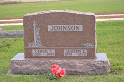
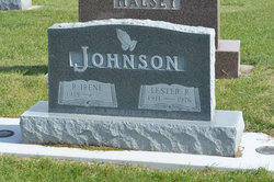
Andrew Emil Johan Johnson
| Birth | : | 23 Jan 1879 Tidersrum, Kinda kommun, Östergötlands län, Sweden |
| Death | : | 24 Mar 1970 Webster City, Hamilton County, Iowa, USA |
| Burial | : | South Marion Cemetery, Stratford, Hamilton County, USA |
| Coordinate | : | 42.2327995, -93.8735962 |
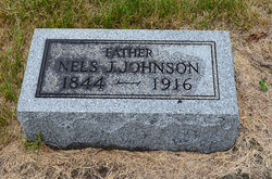
| Description | : | Daily Freeman Journal Webster City, IA March 26, 1970 JOHNSON RITES TO BE FRIDAY Funeral services for Andrew E. Johnson, 91, longtime Stratford area resident, will be held at 2 p.m. Friday at the South Marion United Methodist Church south of Stratford. The Rev. Robert Winter will officiate and burial will be in the South Marion Cemetery. The body will lie in state at the Foster Funeral Home until 9:30 a.m. Friday when it will be taken to the church. Mr. Johnson died Tuesday morning at the Hamilton County Hospital following a brief illness. Andrew Emil Johnson, son of Nels J. and Matilda Anderson Johnson, was born... Read More |
frequently asked questions (FAQ):
-
Where is Andrew Emil Johan Johnson's memorial?
Andrew Emil Johan Johnson's memorial is located at: South Marion Cemetery, Stratford, Hamilton County, USA.
-
When did Andrew Emil Johan Johnson death?
Andrew Emil Johan Johnson death on 24 Mar 1970 in Webster City, Hamilton County, Iowa, USA
-
Where are the coordinates of the Andrew Emil Johan Johnson's memorial?
Latitude: 42.2327995
Longitude: -93.8735962
Family Members:
Parent
Spouse

Siblings

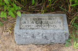
Children


Flowers:


Nearby Cemetories:
1. South Marion Cemetery
Stratford, Hamilton County, USA
Coordinate: 42.2327995, -93.8735962
2. Oakwood Cemetery
Stratford, Hamilton County, USA
Coordinate: 42.2942009, -93.9182968
3. Mineral Ridge Cemetery
Ridgeport, Boone County, USA
Coordinate: 42.1749992, -93.9266968
4. Hooks Point Cemetery
Hamilton County, USA
Coordinate: 42.2944530, -93.9199090
5. Hardin Township Cemetery
Hardin Township, Webster County, USA
Coordinate: 42.2411003, -93.9708023
6. Saint Paul Lutheran Cemetery
Boone, Boone County, USA
Coordinate: 42.1700000, -93.8070000
7. Boone County Poor Farm Cemetery
Boone County, USA
Coordinate: 42.1591100, -93.9159000
8. White Cemetery
Boone County, USA
Coordinate: 42.1777992, -93.9636002
9. Lake Center Cemetery
Stanhope, Hamilton County, USA
Coordinate: 42.2482986, -93.7568970
10. Leininger Cemetery
Boone County, USA
Coordinate: 42.1492004, -93.8356018
11. Lawn Hill Cemetery
Stanhope, Hamilton County, USA
Coordinate: 42.2677994, -93.7611008
12. Nesse Cemetery
Hamilton County, USA
Coordinate: 42.3250008, -93.8933029
13. Neese Cemetery
Homer, Hamilton County, USA
Coordinate: 42.3250000, -93.8935000
14. Linn Cemetery
Pilot Mound, Boone County, USA
Coordinate: 42.2045330, -93.9970230
15. Vegors Cemetery
Webster County, USA
Coordinate: 42.3177986, -93.9421997
16. Mackey Cemetery
Boone County, USA
Coordinate: 42.1675000, -93.7565000
17. Runyan Cemetery
Pilot Mound, Boone County, USA
Coordinate: 42.1749992, -94.0015030
18. Saint Pauls Church Cemetery
Jewell, Hamilton County, USA
Coordinate: 42.2490100, -93.7173400
19. Schlicht Cemetery
Fraser, Boone County, USA
Coordinate: 42.1444200, -93.9780100
20. Bass Cemetery
Dayton, Webster County, USA
Coordinate: 42.2966995, -94.0149994
21. Saratoga Cemetery
Stanhope, Hamilton County, USA
Coordinate: 42.3539009, -93.8167038
22. Pilot Mound Cemetery
Pilot Mound, Boone County, USA
Coordinate: 42.1636200, -94.0282600
23. Ellsworth Clear Lake Cemetery
Randall, Hamilton County, USA
Coordinate: 42.2268930, -93.6926200
24. Bass Point Cemetery
Boone, Boone County, USA
Coordinate: 42.0992012, -93.8957977