
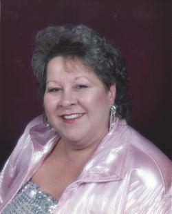
Anna Charline Boles Watson
| Birth | : | 17 May 1950 Tennessee, USA |
| Death | : | 4 Oct 2015 Baptist Ridge, Clay County, Tennessee, USA |
| Burial | : | Doc Hall Cemetery, Clay County, USA |
| Coordinate | : | 36.4995390, -85.5369270 |
| Description | : | HILHAM – Ms. Anna Charline (Boles) Watson, age 65, of the Baptist Ridge Community of Clay County, Tennessee passed away due to complications of congestive heart failure at her residence on Sunday, October 4, 2015. Anna Charline Boles was born on Baptist Ridge on May 17, 1950 to the late Archie and Mary Frances “Black” (Abney) Boles. She was married on April 05, 1975 to the late James Kenneth Watson, who preceded her in death on November 18, 1990. Charline was the owner and operator of the Gone Country Café in Celina, TN. She was a member of the Oak Grove Church... Read More |
frequently asked questions (FAQ):
-
Where is Anna Charline Boles Watson's memorial?
Anna Charline Boles Watson's memorial is located at: Doc Hall Cemetery, Clay County, USA.
-
When did Anna Charline Boles Watson death?
Anna Charline Boles Watson death on 4 Oct 2015 in Baptist Ridge, Clay County, Tennessee, USA
-
Where are the coordinates of the Anna Charline Boles Watson's memorial?
Latitude: 36.4995390
Longitude: -85.5369270
Family Members:
Parent
Spouse
Flowers:


Nearby Cemetories:
1. Doc Hall Cemetery
Clay County, USA
Coordinate: 36.4995390, -85.5369270
2. Hall Cemetery
Clay County, USA
Coordinate: 36.4994011, -85.5366974
3. John Hamilton Cemetery
Butlers Landing, Clay County, USA
Coordinate: 36.4916010, -85.5489080
4. Mabry Cemetery
Clay County, USA
Coordinate: 36.5139008, -85.5464020
5. Emberton Cemetery
Celina, Clay County, USA
Coordinate: 36.4862150, -85.5237040
6. Hamilton Cemetery
Clay County, USA
Coordinate: 36.5181007, -85.5338974
7. Butlers Landing Cemetery
Celina, Clay County, USA
Coordinate: 36.4941300, -85.5600410
8. McColgan Cemetery
Clay County, USA
Coordinate: 36.5163994, -85.5560989
9. Kirk Cemetery
Clay County, USA
Coordinate: 36.4960670, -85.5661650
10. McDonald Cemetery
Baptist Ridge, Clay County, USA
Coordinate: 36.4855995, -85.5119019
11. Lester Brown Family Cemetery
Arcott, Clay County, USA
Coordinate: 36.5205700, -85.5547530
12. M R Cemetery
Baptist Ridge, Clay County, USA
Coordinate: 36.4769100, -85.5196770
13. Roberts Cemetery
Celina, Clay County, USA
Coordinate: 36.5066986, -85.5727997
14. Archibald Plumlee Cemetery
Pine Hill, Clay County, USA
Coordinate: 36.5203018, -85.5682983
15. Rich Cemetery
Baptist Ridge, Clay County, USA
Coordinate: 36.4757080, -85.4991700
16. Goolsby Cemetery
Clay County, USA
Coordinate: 36.4603640, -85.5368040
17. Turkeytown Cemetery
Clay County, USA
Coordinate: 36.4569016, -85.5177994
18. Dalton Cemetery
Arcott, Clay County, USA
Coordinate: 36.5429540, -85.5546170
19. Amos Kirkpatrick-Tinsley Cemetery
Jackson County, USA
Coordinate: 36.4715080, -85.5867230
20. John Fowler Cemetery
Butlers Landing, Clay County, USA
Coordinate: 36.4910900, -85.5972590
21. High Cedar Cemetery
Clay County, USA
Coordinate: 36.4827710, -85.5974970
22. Rich-Lynn Family Cemetery
Butlers Landing, Clay County, USA
Coordinate: 36.4794140, -85.5987380
23. Hix Cemetery
Jackson County, USA
Coordinate: 36.4580810, -85.5815000
24. Peterman Bend Cemetery
Celina, Clay County, USA
Coordinate: 36.5370750, -85.4846300