
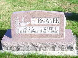
Anna Cuda Formanek
| Birth | : | 1881 |
| Death | : | 1968 |
| Burial | : | New Hope Memorial Gardens, Asheboro, Randolph County, USA |
| Coordinate | : | 35.5975400, -79.8155130 |
frequently asked questions (FAQ):
-
Where is Anna Cuda Formanek's memorial?
Anna Cuda Formanek's memorial is located at: New Hope Memorial Gardens, Asheboro, Randolph County, USA.
-
When did Anna Cuda Formanek death?
Anna Cuda Formanek death on 1968 in
-
Where are the coordinates of the Anna Cuda Formanek's memorial?
Latitude: 35.5975400
Longitude: -79.8155130
Family Members:
Parent
Spouse

Siblings


Children

Flowers:


Nearby Cemetories:
1. New Hope Memorial Gardens
Asheboro, Randolph County, USA
Coordinate: 35.5975400, -79.8155130
2. Antioch Missionary Baptist Church Cemetery
Asheboro, Randolph County, USA
Coordinate: 35.6014220, -79.8159830
3. Flag Springs United Methodist Church Cemetery
Asheboro, Randolph County, USA
Coordinate: 35.6102860, -79.8068910
4. Old New Hope Cemetery
Union Township, Randolph County, USA
Coordinate: 35.5842500, -79.8230000
5. Grace Baptist Temple Cemetery
Asheboro, Randolph County, USA
Coordinate: 35.5843810, -79.8023330
6. New Hope United Methodist Church Cemetery
Asheboro, Randolph County, USA
Coordinate: 35.5804900, -79.8197100
7. Mitchell United Methodist Church Cemetery #2
Asheboro, Randolph County, USA
Coordinate: 35.6221700, -79.7929700
8. Mitchell United Methodist Church Cemetery #1
Asheboro, Randolph County, USA
Coordinate: 35.6233300, -79.7910600
9. Russells Grove Baptist Church Cemetery
Asheboro, Randolph County, USA
Coordinate: 35.6304300, -79.8266700
10. Huldah Baptist Church Cemetery
Asheboro, Randolph County, USA
Coordinate: 35.5779360, -79.7753080
11. Tucker Cemetery
Seagrove, Randolph County, USA
Coordinate: 35.5574900, -79.8091700
12. Pleasant Hill Primitive Baptist Cemetery
Asheboro, Randolph County, USA
Coordinate: 35.5570850, -79.8279590
13. Victory Baptist Church Cemetery
Asheboro, Randolph County, USA
Coordinate: 35.5604090, -79.7907740
14. Richard Graves Family Cemetery
Seagrove, Randolph County, USA
Coordinate: 35.5611100, -79.7679100
15. Boling Family Cemetery
Seagrove, Randolph County, USA
Coordinate: 35.5457340, -79.7999280
16. King Family Cemetery
Seagrove, Randolph County, USA
Coordinate: 35.5465290, -79.7920060
17. Cox Family Cemetery
Seagrove, Randolph County, USA
Coordinate: 35.5428000, -79.8378300
18. Pisgah United Methodist Church Cemetery
Asheboro, Randolph County, USA
Coordinate: 35.5582710, -79.8699840
19. Panther Creek Baptist Church Cemetery
Asheboro, Randolph County, USA
Coordinate: 35.6176300, -79.7437820
20. Seagrove United Methodist Church Cemetery
Seagrove, Randolph County, USA
Coordinate: 35.5401900, -79.7804200
21. Hopewell Friends Meeting Cemetery
Asheboro, Randolph County, USA
Coordinate: 35.6390840, -79.8765500
22. Nathaniel Tucker Cemetery
Seagrove, Randolph County, USA
Coordinate: 35.5328000, -79.8231300
23. High Pine Wesleyan Church Cemetery
Asheboro, Randolph County, USA
Coordinate: 35.5815239, -79.8943787
24. Lucas Family Cemetery
Seagrove, Randolph County, USA
Coordinate: 35.5311852, -79.8127899