
| Birth | : | 10 Apr 1930 Iowa, USA |
| Death | : | 26 Dec 2002 Iowa, USA |
| Burial | : | Warwick General Cemetery, Warwick, Southern Downs Region, Australia |
| Coordinate | : | -28.2100890, 152.0044080 |
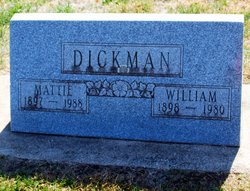
| Description | : | Daughter of William & Mattie Schrage Dickman 1940 United States Federal Census Name: Anna Elizabeth Dickman Estimated Birth Year: abt 1930 Birthplace: Iowa Relation to Head of House: Daughter Home in 1940: Clarksville, Butler, Iowa Father's Birthplace: Iowa Mother's Birthplace: Iowa Attended School or College: Yes Highest Grade Completed: Elementary school, 4th grade Native Language: English Household Members: William Dickman 41, Mattie Dickman 42, Anna Elizabeth Dickman 10. Anna Elizabeth (Green) DeBower, age 72, of Waverly, Iowa, and formerly of Allison, Iowa, was born the daughter of William and Mattie (Schrage) Dickman on April 10, 1930, in Waverly, Iowa. She received her education in Clarksville and graduated from the Clarksville High School. Anna... Read More |
frequently asked questions (FAQ):
-
Where is Anna Elizabeth Dickman DeBower's memorial?
Anna Elizabeth Dickman DeBower's memorial is located at: Warwick General Cemetery, Warwick, Southern Downs Region, Australia.
-
When did Anna Elizabeth Dickman DeBower death?
Anna Elizabeth Dickman DeBower death on 26 Dec 2002 in Iowa, USA
-
Where are the coordinates of the Anna Elizabeth Dickman DeBower's memorial?
Latitude: -28.2100890
Longitude: 152.0044080
Family Members:
Parent

Flowers:


Nearby Cemetories:
1. Warwick General Lawn Cemetery
Warwick, Southern Downs Region, Australia
Coordinate: -28.2106310, 152.0039087
2. Warwick War Cemetery
Warwick, Southern Downs Region, Australia
Coordinate: -28.2089620, 152.0033530
3. Eden Gardens Memorial Park
Warwick, Southern Downs Region, Australia
Coordinate: -28.2229690, 152.0031130
4. St Marks Anglican Church Columbarium Wall
Warwick, Southern Downs Region, Australia
Coordinate: -28.2161000, 152.0347600
5. Lone Grave Warwick
Warwick, Southern Downs Region, Australia
Coordinate: -28.2316590, 151.9833180
6. Warwick-Conway Family Homestead Cemetery
Warwick, Southern Downs Region, Australia
Coordinate: -28.1258400, 152.0395700
7. Swan Creek Anglican Cemetery
Swan Creek, Southern Downs Region, Australia
Coordinate: -28.1974400, 152.1364830
8. Glengallan Station
Warwick, Southern Downs Region, Australia
Coordinate: -28.1027016, 152.0585067
9. Yangan Presbyterian Church Cemetery
Yangan, Southern Downs Region, Australia
Coordinate: -28.1972310, 152.2142130
10. Yangan General and Anglican Cemetery
Emu Vale, Southern Downs Region, Australia
Coordinate: -28.2059990, 152.2207110
11. Allora Cemetery
Allora, Southern Downs Region, Australia
Coordinate: -28.0199230, 151.9750720
12. Pratten Cemetery
Pratten, Southern Downs Region, Australia
Coordinate: -28.0858450, 151.7790540
13. Dalveen-Mitchell Family Homestead Cemetery
Dalveen, Southern Downs Region, Australia
Coordinate: -28.4423200, 151.9604000
14. Maryvale Homestead Cemetery
Warwick, Southern Downs Region, Australia
Coordinate: -28.0669430, 152.2405230
15. Maryvale Cemetery
Maryvale, Southern Downs Region, Australia
Coordinate: -28.0607800, 152.2474610
16. Killarney Lawn Cemetery
Killarney, Southern Downs Region, Australia
Coordinate: -28.3475760, 152.2742790
17. Strath Elbess Cemetery
Dalveen, Southern Downs Region, Australia
Coordinate: -28.4883070, 151.9692850
18. Clifton General Cemetery
Clifton, Toowoomba Region, Australia
Coordinate: -27.9389150, 151.9120790
19. Headington Hill Lutheran Cemetery
Allora, Southern Downs Region, Australia
Coordinate: -27.9037210, 152.0020290
20. Back Plains Cemetery
Back Plains, Toowoomba Region, Australia
Coordinate: -27.9121770, 151.7970240
21. Spicers Gap
Boonah, Scenic Rim Region, Australia
Coordinate: -28.0733318, 152.4255524
22. Nobby Cemetery
Nobby, Toowoomba Region, Australia
Coordinate: -27.8322200, 151.8662000
23. Leyburn Cemetery
Leyburn, Southern Downs Region, Australia
Coordinate: -28.0085654, 151.5913366
24. Lone Grave Leyburn
Leyburn, Southern Downs Region, Australia
Coordinate: -28.0189540, 151.5842910