
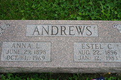
Anna Louise Dickey Andrews
| Birth | : | 29 Jun 1898 Missouri, USA |
| Death | : | 1 Oct 1969 Lancaster, Schuyler County, Missouri, USA |
| Burial | : | Saint John's Cemetery, Lancaster, Worcester County, USA |
| Coordinate | : | 42.4328003, -71.6977997 |
| Description | : | According to the Rainbolt Genealogy Book: Page#: 172 Individual # 626 {s} ****************************** Individual# : K Z J R - 3 8 5 ****************************** NO death notice / obituary located as of 14 March 2021 ******************************* 1940 Census @ : 99 - 7, Lancaster, Schuyler County, Missouri Page#14 Individual# 60 *********************************** NO Death Certificate - or - Obituary Located as of 1 February 2020 ************************************ |
frequently asked questions (FAQ):
-
Where is Anna Louise Dickey Andrews's memorial?
Anna Louise Dickey Andrews's memorial is located at: Saint John's Cemetery, Lancaster, Worcester County, USA.
-
When did Anna Louise Dickey Andrews death?
Anna Louise Dickey Andrews death on 1 Oct 1969 in Lancaster, Schuyler County, Missouri, USA
-
Where are the coordinates of the Anna Louise Dickey Andrews's memorial?
Latitude: 42.4328003
Longitude: -71.6977997
Family Members:
Parent
Spouse

Siblings

Children
Flowers:


Nearby Cemetories:
1. Saint John's Cemetery
Lancaster, Worcester County, USA
Coordinate: 42.4328003, -71.6977997
2. Woodlawn Cemetery
Clinton, Worcester County, USA
Coordinate: 42.4185982, -71.6889038
3. Middle Cemetery
Lancaster, Worcester County, USA
Coordinate: 42.4491997, -71.6757965
4. Old Settlers Burial Yard
Lancaster, Worcester County, USA
Coordinate: 42.4488754, -71.6742706
5. Thayer Cemetery
Lancaster, Worcester County, USA
Coordinate: 42.4578500, -71.7024400
6. Reservoir Pines Cemetery
Clinton, Worcester County, USA
Coordinate: 42.4084900, -71.7109700
7. Old Common Burial Ground
Lancaster, Worcester County, USA
Coordinate: 42.4426700, -71.6645300
8. Fairbank Burial Ground
Sterling, Worcester County, USA
Coordinate: 42.4152600, -71.7320000
9. Eastwood Cemetery
Lancaster, Worcester County, USA
Coordinate: 42.4417000, -71.6528015
10. Hillside Cemetery
Sterling, Worcester County, USA
Coordinate: 42.4410000, -71.7492570
11. Oak Hill Cemetery
Sterling, Worcester County, USA
Coordinate: 42.4417000, -71.7493973
12. North Village Cemetery
Lancaster, Worcester County, USA
Coordinate: 42.4724998, -71.6778030
13. Chocksett Burial Ground
Sterling, Worcester County, USA
Coordinate: 42.4377000, -71.7555400
14. West Burying Ground
Bolton, Worcester County, USA
Coordinate: 42.4488983, -71.6300964
15. West Cemetery
Sterling, Worcester County, USA
Coordinate: 42.4514100, -71.7651400
16. Cookshire Cemetery
Sterling, Worcester County, USA
Coordinate: 42.4108500, -71.7734800
17. Old Fry Burying Ground
Bolton, Worcester County, USA
Coordinate: 42.4077300, -71.6209900
18. Friends Burial Ground
Bolton, Worcester County, USA
Coordinate: 42.4133620, -71.6176710
19. North Cemetery
Berlin, Worcester County, USA
Coordinate: 42.4037000, -71.6225100
20. Old South Burying Ground
Bolton, Worcester County, USA
Coordinate: 42.4231000, -71.6096500
21. Saint Lukes Cemetery
West Boylston, Worcester County, USA
Coordinate: 42.3833008, -71.7568970
22. Old Burying Ground
Berlin, Worcester County, USA
Coordinate: 42.3811646, -71.6375351
23. Saint Benedict Center Cemetery
Harvard, Worcester County, USA
Coordinate: 42.4827900, -71.6231900
24. Legg Cemetery
Sterling, Worcester County, USA
Coordinate: 42.4070020, -71.7986150