
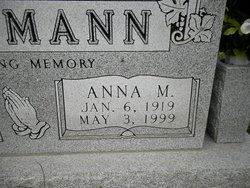
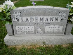

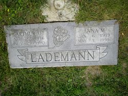
Anna Marie Bilyeu Lademann
| Birth | : | 6 Jan 1919 Moniteau County, Missouri, USA |
| Death | : | 3 May 1999 Jefferson City, Cole County, Missouri, USA |
| Burial | : | St Oswald Churchyard, Horton-in-Ribblesdale, Craven District, England |
| Coordinate | : | 54.1445140, -2.2922550 |
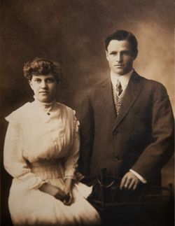
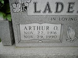
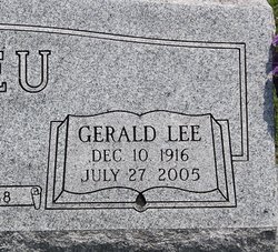
| Description | : | Anna Marie Lademann, 80, California, died May 3, 1999, at St. Marys Health Center. She was born Jan. 6, 1919, in Moniteau County, a daughter of Leonard and Etta Belle Bolin Bilyeu. She was married Dec. 19, 1937, in California, to Arthur O. Lademann, who died Nov. 29, 1990. She attended Norman School. She was a homemaker and a member of St. Pauls Lutheran Church, California, and St. Pauls Seniors. Survivors include: one son, Dennis Lademann, Columbia; one daughter, Betty Hays, California; two brothers, Gerald "Lee" Bilyeu and Dale Bilyeu, both of California; nine sisters, Melva Eveland and Brenda Burton, both of Camdenton,... Read More |
frequently asked questions (FAQ):
-
Where is Anna Marie Bilyeu Lademann's memorial?
Anna Marie Bilyeu Lademann's memorial is located at: St Oswald Churchyard, Horton-in-Ribblesdale, Craven District, England.
-
When did Anna Marie Bilyeu Lademann death?
Anna Marie Bilyeu Lademann death on 3 May 1999 in Jefferson City, Cole County, Missouri, USA
-
Where are the coordinates of the Anna Marie Bilyeu Lademann's memorial?
Latitude: 54.1445140
Longitude: -2.2922550
Family Members:
Parent

Spouse
Siblings

Flowers:


Nearby Cemetories:
1. St Oswald Churchyard
Horton-in-Ribblesdale, Craven District, England
Coordinate: 54.1445140, -2.2922550
2. St Peter Churchyard
Stainforth, Craven District, England
Coordinate: 54.1019280, -2.2754890
3. Austwick Church Cemetery
Austwick, Craven District, England
Coordinate: 54.1081700, -2.3660600
4. St James Churchyard
Clapham, Craven District, England
Coordinate: 54.1202400, -2.3904970
5. St John the Evangelist Churchyard
Langcliffe, Craven District, England
Coordinate: 54.0807400, -2.2721000
6. Clapham Parish Cemetery
Clapham, Craven District, England
Coordinate: 54.1110400, -2.3963100
7. St Alkelda Churchyard
Giggleswick, Craven District, England
Coordinate: 54.0721700, -2.2894600
8. Holy Ascension Churchyard
Settle, Craven District, England
Coordinate: 54.0704320, -2.2775390
9. Friends Burial Ground
Settle, Craven District, England
Coordinate: 54.0685370, -2.2791100
10. Zion Congregational Chapelyard
Settle, Craven District, England
Coordinate: 54.0672490, -2.2747040
11. St Leonard Churchyard
Chapel-le-Dale, Craven District, England
Coordinate: 54.1897200, -2.4032880
12. St. Matthew's Churchyard
Keasden, Craven District, England
Coordinate: 54.0945680, -2.4245830
13. Ingleton Cemetery
Ingleton, Craven District, England
Coordinate: 54.1495470, -2.4569780
14. St Mary Churchyard
Ingleton, Craven District, England
Coordinate: 54.1540480, -2.4682980
15. Holy Trinity Churchyard
Rathmell, Craven District, England
Coordinate: 54.0351000, -2.3002300
16. St Oswald Churchyard
Arncliffe, Craven District, England
Coordinate: 54.1434970, -2.1038940
17. St Oswald Churchyard
Thornton-in-Lonsdale, Craven District, England
Coordinate: 54.1573600, -2.4830810
18. Brocklands Woodland Burial Site
Rathmell, Craven District, England
Coordinate: 54.0275720, -2.2998880
19. St. Michael and All Angels Churchyard
Hubberholme, Craven District, England
Coordinate: 54.2001100, -2.1147330
20. St Michael the Archangel Churchyard
Kirkby Malham, Craven District, England
Coordinate: 54.0448480, -2.1628540
21. Long Preston Baptist Chapel
Long Preston, Craven District, England
Coordinate: 54.0204249, -2.2560031
22. St Mary the Virgin Churchyard
Long Preston, Craven District, England
Coordinate: 54.0183790, -2.2497690
23. St Margaret Churchyard
Bentham, Craven District, England
Coordinate: 54.1146000, -2.5087300
24. All Saints Churchyard
Burton-in-Lonsdale, Craven District, England
Coordinate: 54.1437630, -2.5357130