Anna Marie Leitzke Schwartz
| Birth | : | 28 Sep 1868 Hustisford, Dodge County, Wisconsin, USA |
| Death | : | 9 Nov 1927 Stanton, Stanton County, Nebraska, USA |
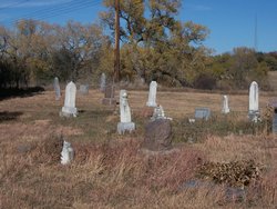
| Burial | : | Belz Cemetery, Stanton, Stanton County, USA |
| Coordinate | : | 41.9528008, -97.2619019 |
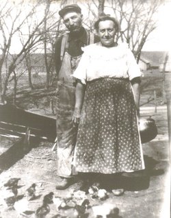
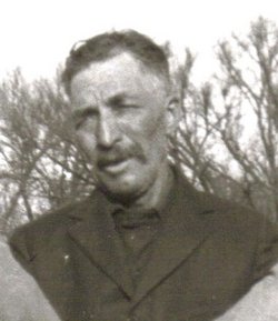
| Description | : | Anna married William Schwartz April 3, 1888 in Neola, Pottawattamie, Iowa. When Anna Marie Leitzke was born on September 28, 1868, in Dodge, Wisconsin, her father, Carl Frederich August Leitzke, was 41, and her mother, Albertine A. Wilhemina Brumond Leitzke, was 38. She married Wilhelm Tobias "William" Schwartz on April 3, 1888, in Neola, Iowa and they had 11 children together. She died on November 9, 1927, in Stanton, Nebraska, at the age of 59, and was buried there. Children: Adolph Paul Schwartz 1889–1954 Daniel Carl Schwartz 1891–1893 Herbert Lorenz Schwartz 1892–1965 Esther Heartha Tresea Schwartz 1894–1959 Minnie Agnes... Read More |
frequently asked questions (FAQ):
-
Where is Anna Marie Leitzke Schwartz's memorial?
Anna Marie Leitzke Schwartz's memorial is located at: Belz Cemetery, Stanton, Stanton County, USA.
-
When did Anna Marie Leitzke Schwartz death?
Anna Marie Leitzke Schwartz death on 9 Nov 1927 in Stanton, Stanton County, Nebraska, USA
-
Where are the coordinates of the Anna Marie Leitzke Schwartz's memorial?
Latitude: 41.9528008
Longitude: -97.2619019
Family Members:
Spouse
Siblings
Children
Flowers:
Nearby Cemetories:
1. Belz Cemetery
Stanton, Stanton County, USA
Coordinate: 41.9528008, -97.2619019
2. Zilmer Cemetery
Stanton, Stanton County, USA
Coordinate: 41.9464000, -97.2528000
3. Stanton Cemetery
Stanton, Stanton County, USA
Coordinate: 41.9599991, -97.2121964
4. Hoosier Hollow Pioneer Cemetery
Stanton County, USA
Coordinate: 41.9900017, -97.2814026
5. Norwegian Cemetery
Stanton, Stanton County, USA
Coordinate: 41.9171600, -97.2907160
6. Koch Cemetery
Stanton County, USA
Coordinate: 41.9855995, -97.1731033
7. Zander Cemetery
Stanton County, USA
Coordinate: 41.9888992, -97.1750031
8. Bethlehem Cemetery
Stanton County, USA
Coordinate: 42.0332985, -97.2241974
9. Erychleb Cemetery
Stanton County, USA
Coordinate: 41.8664017, -97.2138977
10. Elkhorn Cemetery
Pilger, Stanton County, USA
Coordinate: 41.9899910, -97.1316720
11. Zion Cemetery
Stanton County, USA
Coordinate: 42.0421982, -97.3638992
12. Kuehn Cemetery
Pilger, Stanton County, USA
Coordinate: 41.9682000, -97.1049000
13. Christ Lutheran Cemetery
Stanton County, USA
Coordinate: 42.0433006, -97.3636017
14. Pleasant Valley Cemetery
Madison County, USA
Coordinate: 41.8877983, -97.3972015
15. Bega Cemetery
Stanton County, USA
Coordinate: 42.0736008, -97.2343979
16. Norfolk State Hospital New Cemetery
Norfolk, Madison County, USA
Coordinate: 42.0475500, -97.3698300
17. Norfolk State Hospital Old Cemetery
Norfolk, Madison County, USA
Coordinate: 42.0535400, -97.3733100
18. Spring Branch Cemetery
Spring Branch Township, Stanton County, USA
Coordinate: 42.0789400, -97.3297400
19. Muller Cemetery
Pilger, Stanton County, USA
Coordinate: 42.0780940, -97.1781920
20. Trinity Epsicopal Church Columbarium
Norfolk, Madison County, USA
Coordinate: 42.0317000, -97.4191000
21. New Lutheran Cemetery
Norfolk, Madison County, USA
Coordinate: 42.0397900, -97.4223600
22. Saint Paul Cemetery
Norfolk, Madison County, USA
Coordinate: 42.0438995, -97.4244003
23. Prospect Hill Cemetery
Norfolk, Madison County, USA
Coordinate: 42.0407982, -97.4289017
24. Trinity Cemetery
Hoskins, Wayne County, USA
Coordinate: 42.1055984, -97.3274994


