
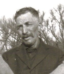
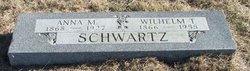

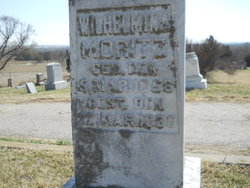
Wilhelm Tobias “William” Schwartz
| Birth | : | 13 Jun 1866 Stanton, Stanton County, Nebraska, USA |
| Death | : | 10 Jan 1958 Council Bluffs, Pottawattamie County, Iowa, USA |
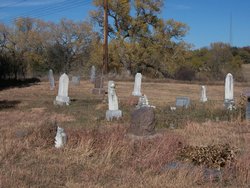
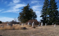
| Burial | : | Belz Cemetery, Stanton, Stanton County, USA |
| Coordinate | : | 41.9528008, -97.2619019 |
| Description | : | In 1865 Nebraska opened to settlers and land could be acquired as homesteads. Carl Fredrich Schwartz and Caroline Werbelow set out from Wisconsin for Nebraska, with oxen and wagon. Caroline walked all the way, as she was pregnant and the wagon had no springs. They spent the winter in Rock Creek in Cuming County, Nebraska. In spring 1866 they homesteaded 160 acres of land four miles southeast from the place where Stanton, Nebraska is now situated. Here they established their home; this land bordered the Elkhorn River. They were fortunate that there was wood for fuel as well as for... Read More |
frequently asked questions (FAQ):
-
Where is Wilhelm Tobias “William” Schwartz's memorial?
Wilhelm Tobias “William” Schwartz's memorial is located at: Belz Cemetery, Stanton, Stanton County, USA.
-
When did Wilhelm Tobias “William” Schwartz death?
Wilhelm Tobias “William” Schwartz death on 10 Jan 1958 in Council Bluffs, Pottawattamie County, Iowa, USA
-
Where are the coordinates of the Wilhelm Tobias “William” Schwartz's memorial?
Latitude: 41.9528008
Longitude: -97.2619019
Family Members:
Parent

Spouse

Siblings


Children
Flowers:


Nearby Cemetories:
1. Belz Cemetery
Stanton, Stanton County, USA
Coordinate: 41.9528008, -97.2619019
2. Zilmer Cemetery
Stanton, Stanton County, USA
Coordinate: 41.9464000, -97.2528000
3. Stanton Cemetery
Stanton, Stanton County, USA
Coordinate: 41.9599991, -97.2121964
4. Hoosier Hollow Pioneer Cemetery
Stanton County, USA
Coordinate: 41.9900017, -97.2814026
5. Norwegian Cemetery
Stanton, Stanton County, USA
Coordinate: 41.9171600, -97.2907160
6. Koch Cemetery
Stanton County, USA
Coordinate: 41.9855995, -97.1731033
7. Zander Cemetery
Stanton County, USA
Coordinate: 41.9888992, -97.1750031
8. Bethlehem Cemetery
Stanton County, USA
Coordinate: 42.0332985, -97.2241974
9. Erychleb Cemetery
Stanton County, USA
Coordinate: 41.8664017, -97.2138977
10. Elkhorn Cemetery
Pilger, Stanton County, USA
Coordinate: 41.9899910, -97.1316720
11. Zion Cemetery
Stanton County, USA
Coordinate: 42.0421982, -97.3638992
12. Kuehn Cemetery
Pilger, Stanton County, USA
Coordinate: 41.9682000, -97.1049000
13. Christ Lutheran Cemetery
Stanton County, USA
Coordinate: 42.0433006, -97.3636017
14. Pleasant Valley Cemetery
Madison County, USA
Coordinate: 41.8877983, -97.3972015
15. Bega Cemetery
Stanton County, USA
Coordinate: 42.0736008, -97.2343979
16. Norfolk State Hospital New Cemetery
Norfolk, Madison County, USA
Coordinate: 42.0475500, -97.3698300
17. Norfolk State Hospital Old Cemetery
Norfolk, Madison County, USA
Coordinate: 42.0535400, -97.3733100
18. Spring Branch Cemetery
Spring Branch Township, Stanton County, USA
Coordinate: 42.0789400, -97.3297400
19. Muller Cemetery
Pilger, Stanton County, USA
Coordinate: 42.0780940, -97.1781920
20. Trinity Epsicopal Church Columbarium
Norfolk, Madison County, USA
Coordinate: 42.0317000, -97.4191000
21. New Lutheran Cemetery
Norfolk, Madison County, USA
Coordinate: 42.0397900, -97.4223600
22. Saint Paul Cemetery
Norfolk, Madison County, USA
Coordinate: 42.0438995, -97.4244003
23. Prospect Hill Cemetery
Norfolk, Madison County, USA
Coordinate: 42.0407982, -97.4289017
24. Trinity Cemetery
Hoskins, Wayne County, USA
Coordinate: 42.1055984, -97.3274994