
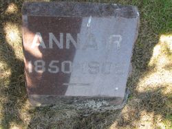
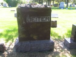
Anna Rosina Fischer Deiter
| Birth | : | Jul 1850 Wisconsin, USA |
| Death | : | 11 Sep 1906 Minnesota, USA |
| Burial | : | Holy Trinity Churchyard, Messingham, North Lincolnshire Unitary Authority, England |
| Coordinate | : | 53.5323250, -0.6583030 |
| Plot | : | Division B, Block 026, Grave 009 |
| Description | : | Mrs. Anna Dieter of Redfield Found Dead in Berth Redfield, S. D. Sept 13. - Mrs. Anna Dieter of this town died yesterday on the Northwestern westbound passenger [train] between Tracy and Marshall [Minnesota]. She had been to a hospital in the twin cities where she underwent an operation. The result was thought to be successful, and accompanied by a daughter and a nurse, she left the hospital Monday afternoon to return to her home. Death overtook her in her berth in the sleeper. The remains were brought here where the funeral service will be held and the body laid to... Read More |
frequently asked questions (FAQ):
-
Where is Anna Rosina Fischer Deiter's memorial?
Anna Rosina Fischer Deiter's memorial is located at: Holy Trinity Churchyard, Messingham, North Lincolnshire Unitary Authority, England.
-
When did Anna Rosina Fischer Deiter death?
Anna Rosina Fischer Deiter death on 11 Sep 1906 in Minnesota, USA
-
Where are the coordinates of the Anna Rosina Fischer Deiter's memorial?
Latitude: 53.5323250
Longitude: -0.6583030
Family Members:
Spouse
Children
Flowers:


Nearby Cemetories:
1. Holy Trinity Churchyard
Messingham, North Lincolnshire Unitary Authority, England
Coordinate: 53.5323250, -0.6583030
2. St Peter Ad Vincula Church
Bottesford, North Lincolnshire Unitary Authority, England
Coordinate: 53.5533120, -0.6448410
3. St Peter Churchyard
Scotter, West Lindsey District, England
Coordinate: 53.4966600, -0.6636500
4. Scotter Cemetery
Scotter, West Lindsey District, England
Coordinate: 53.4942000, -0.6665520
5. Saint Hybald Churchyard
Manton, North Lincolnshire Unitary Authority, England
Coordinate: 53.5125000, -0.5931000
6. Brumby Cemetery
Scunthorpe, North Lincolnshire Unitary Authority, England
Coordinate: 53.5799400, -0.6448700
7. Woodlands Cemetery and Crematorium
Scunthorpe, North Lincolnshire Unitary Authority, England
Coordinate: 53.5810900, -0.6744900
8. St Mary the Virgin Churchyard
West Butterwick, North Lincolnshire Unitary Authority, England
Coordinate: 53.5426407, -0.7412120
9. Baptist Burial Ground
West Butterwick, North Lincolnshire Unitary Authority, England
Coordinate: 53.5432720, -0.7423210
10. St Genewys Churchyard
Scotton, West Lindsey District, England
Coordinate: 53.4810900, -0.6597690
11. St Lawrence Churchyard
Scunthorpe, North Lincolnshire Unitary Authority, England
Coordinate: 53.5864180, -0.6554010
12. Scunthorpe Cemetery
Scunthorpe, North Lincolnshire Unitary Authority, England
Coordinate: 53.5932400, -0.6512140
13. St John The Baptist Churchyard Extension
Burringham, North Lincolnshire Unitary Authority, England
Coordinate: 53.5708230, -0.7439800
14. Crosby Cemetery
Scunthorpe, North Lincolnshire Unitary Authority, England
Coordinate: 53.5978800, -0.6639600
15. St Oswald Churchyard
Althorpe, North Lincolnshire Unitary Authority, England
Coordinate: 53.5765570, -0.7408910
16. Kirton-in-Lindsey Cemetery
Kirton in Lindsey, North Lincolnshire Unitary Authority, England
Coordinate: 53.4765050, -0.5963870
17. St Andrews Church
Kirton in Lindsey, North Lincolnshire Unitary Authority, England
Coordinate: 53.4755000, -0.5940000
18. St. John's Churchyard
Gainsborough, West Lindsey District, England
Coordinate: 53.4635280, -0.6538310
19. Saint Hybald's Churchyard
Scawby, North Lincolnshire Unitary Authority, England
Coordinate: 53.5384500, -0.5395500
20. St Marys Churchyard
Broughton, North Lincolnshire Unitary Authority, England
Coordinate: 53.5654330, -0.5514190
21. Broughton Church Cemetery
Broughton, North Lincolnshire Unitary Authority, England
Coordinate: 53.5649200, -0.5504110
22. Broughton Cemetery
Broughton, North Lincolnshire Unitary Authority, England
Coordinate: 53.5732500, -0.5582900
23. Laughton Cemetery
Laughton, West Lindsey District, England
Coordinate: 53.4681287, -0.7228939
24. All Saints Churchyard
Laughton, West Lindsey District, England
Coordinate: 53.4656600, -0.7224400