Anne Osborne Roan Drummond
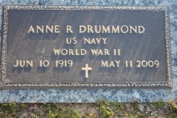
| Birth | : | 10 Jun 1919 Hazard, Perry County, Kentucky, USA |
| Death | : | 11 May 2009 Fairfax County, Virginia, USA |
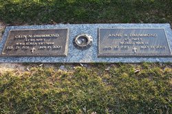
| Burial | : | Bethel Church of the Brethren Cemetery, Carleton, Thayer County, USA |
| Coordinate | : | 40.3499800, -97.7069800 |
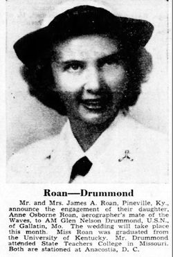
| Description | : | U.S. Navy, WW II. She was a graduate of Pineville High School in Pineville, KY, where her family moved when she was ten years old. She attended Nazareth College, and earned a degree in English from the University of Kentucky. Enlisting in the U.S. Navy as a WAVE after the bombing of Pearl Harbor, she was an aerographer's mate, drawing weather maps. She met and married Glen Nelson Drummond, Jr., U.S. Navy. They moved to the City of Fairfax, VA in 1955 and resided in the same house for 54 years. She and her husband were volunteers... Read More |
frequently asked questions (FAQ):
-
Where is Anne Osborne Roan Drummond's memorial?
Anne Osborne Roan Drummond's memorial is located at: Bethel Church of the Brethren Cemetery, Carleton, Thayer County, USA.
-
When did Anne Osborne Roan Drummond death?
Anne Osborne Roan Drummond death on 11 May 2009 in Fairfax County, Virginia, USA
-
Where are the coordinates of the Anne Osborne Roan Drummond's memorial?
Latitude: 40.3499800
Longitude: -97.7069800
Family Members:
Parent
Spouse
Siblings
Children
Flowers:
Nearby Cemetories:
1. Bethel Church of the Brethren Cemetery
Carleton, Thayer County, USA
Coordinate: 40.3499800, -97.7069800
2. Summit Cemetery
Shickley, Fillmore County, USA
Coordinate: 40.3656006, -97.6913986
3. Salem Cemetery
Shickley, Fillmore County, USA
Coordinate: 40.3945000, -97.6733000
4. Carleton Cemetery
Carleton, Thayer County, USA
Coordinate: 40.2929000, -97.6764000
5. Shickley Cemetery
Shickley, Fillmore County, USA
Coordinate: 40.4166985, -97.7082977
6. Davenport Cemetery
Davenport, Thayer County, USA
Coordinate: 40.3208313, -97.8009949
7. Stockholm Lutheran Cemetery
Fillmore County, USA
Coordinate: 40.4091988, -97.7767029
8. Keim Cemetery
Bruning, Thayer County, USA
Coordinate: 40.3222008, -97.6033020
9. Bruning Public Cemetery
Bruning, Thayer County, USA
Coordinate: 40.3393100, -97.5579000
10. Ong Cemetery
Ong, Clay County, USA
Coordinate: 40.4077988, -97.8367004
11. Trinity Lutheran Cemetery
Bruning, Thayer County, USA
Coordinate: 40.3367800, -97.5566900
12. Zion Lutheran Cemetery
Fillmore County, USA
Coordinate: 40.4668999, -97.7097015
13. Harmony Cemetery
Strang, Fillmore County, USA
Coordinate: 40.3788986, -97.5381012
14. Saint Marys Cemetery
Shickley, Fillmore County, USA
Coordinate: 40.4816700, -97.7295400
15. Belvidere Rural Cemetery
Belvidere, Thayer County, USA
Coordinate: 40.2559200, -97.5489300
16. Fairview Cemetery
Fillmore County, USA
Coordinate: 40.4817009, -97.8133011
17. Bethlehem Cemetery
Kiowa Township, Thayer County, USA
Coordinate: 40.2055800, -97.7838800
18. Friedensau Cemetery
Hebron, Thayer County, USA
Coordinate: 40.1841100, -97.6895500
19. Prairieview Cemetery
Ong, Clay County, USA
Coordinate: 40.4235100, -97.9093400
20. Oak Grove Cemetery
Oak, Nuckolls County, USA
Coordinate: 40.2326889, -97.8739471
21. Chapel Grove Cemetery
Clay County, USA
Coordinate: 40.4660988, -97.8816986
22. Pleasant Plain Cemetery
Bruning, Thayer County, USA
Coordinate: 40.3217010, -97.4738998
23. Rose Hill Cemetery
Hebron, Thayer County, USA
Coordinate: 40.1889000, -97.5960999
24. Saint Josephs Cemetery
Geneva, Fillmore County, USA
Coordinate: 40.5184200, -97.6145000

