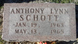
Anthony Lynn “Tony” Schott
| Birth | : | 19 Jan 1963 Iowa City, Johnson County, Iowa, USA |
| Death | : | 13 May 1965 Iowa City, Johnson County, Iowa, USA |
| Burial | : | Saint Stanislaus Cemetery, Iowa City, Johnson County, USA |
| Coordinate | : | 41.5377000, -91.5960000 |
| Description | : | Lone Tree Reporter, Lone Tree, Iowa, Thursday, May 20, 1965 A farm tractor accident Thursday evening took the life of the two year old son of Mr. and Mrs. John B. Schott of near Hills. The youngster, Anthony Schott, had been playing in the farm driveway when he was struck by the tractor which was driven by his father. The Schott farm is located just south of Hills on Highway 218. Johnson County Deputy Sheriff Bert Falls, said the boy's father had brought the tractor into the farm lot for gas and was just pulling out again when... Read More |
frequently asked questions (FAQ):
-
Where is Anthony Lynn “Tony” Schott's memorial?
Anthony Lynn “Tony” Schott's memorial is located at: Saint Stanislaus Cemetery, Iowa City, Johnson County, USA.
-
When did Anthony Lynn “Tony” Schott death?
Anthony Lynn “Tony” Schott death on 13 May 1965 in Iowa City, Johnson County, Iowa, USA
-
Where are the coordinates of the Anthony Lynn “Tony” Schott's memorial?
Latitude: 41.5377000
Longitude: -91.5960000
Family Members:
Parent
Flowers:
Nearby Cemetories:
1. Saint Stanislaus Cemetery
Iowa City, Johnson County, USA
Coordinate: 41.5377000, -91.5960000
2. Mentzer Cemetery
Johnson County, USA
Coordinate: 41.5574989, -91.5888977
3. Sharon Cemetery
Johnson County, USA
Coordinate: 41.5402000, -91.6370000
4. Earhart Cemetery
Hills, Johnson County, USA
Coordinate: 41.5547300, -91.5424800
5. Yoder Family Cemetery
Sharon Center, Johnson County, USA
Coordinate: 41.5666832, -91.6460017
6. Sharon Center Cemetery
Johnson County, USA
Coordinate: 41.5543000, -91.6555000
7. Cline Cemetery
Johnson County, USA
Coordinate: 41.5182100, -91.5336350
8. Riverside Cemetery
Riverside, Washington County, USA
Coordinate: 41.4869003, -91.5785980
9. Mount Olivet Cemetery
Riverside, Washington County, USA
Coordinate: 41.4864006, -91.5802994
10. Saint Vincent Cemetery
Riverside, Washington County, USA
Coordinate: 41.4874992, -91.6188965
11. Saint John Lutheran Cemetery
Sharon Center, Johnson County, USA
Coordinate: 41.5542000, -91.6678000
12. Fairview Mennonite Cemetery
Johnson County, USA
Coordinate: 41.5396000, -91.6751000
13. Eash Cemetery
Johnson County, USA
Coordinate: 41.5800018, -91.6519012
14. John Helmuth Cemetery
Sharon Center, Johnson County, USA
Coordinate: 41.5583870, -91.6764660
15. Peter Miller Cemetery
Johnson County, USA
Coordinate: 41.5214005, -91.6813965
16. Middleburg Cemetery
Kalona, Washington County, USA
Coordinate: 41.4907990, -91.6613998
17. Sandtown Cemetery
Hills, Johnson County, USA
Coordinate: 41.5544014, -91.5068970
18. Welsh Cemetery
Johnson County, USA
Coordinate: 41.6166954, -91.6065369
19. Cooper Cemetery
Riverside, Washington County, USA
Coordinate: 41.4623500, -91.6336500
20. Walker Cemetery
Johnson County, USA
Coordinate: 41.5186005, -91.4903030
21. North Gingerich Sharon Cemetery
Johnson County, USA
Coordinate: 41.5553017, -91.7024994
22. East Union Mennonite Cemetery
Sharon Center, Johnson County, USA
Coordinate: 41.5258179, -91.7049484
23. Sharon Bethel Cemetery
Williamstown, Johnson County, USA
Coordinate: 41.5558000, -91.7086000
24. Moses P Miller Cemetery
Kalona, Washington County, USA
Coordinate: 41.4929610, -91.6960140


