
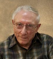
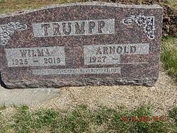
Arnold W. Trumpp
| Birth | : | 23 Feb 1927 Clay Center, Clay County, Kansas, USA |
| Death | : | 28 Jan 2020 Clay Center, Clay County, Kansas, USA |
| Burial | : | Ebenezer Cemetery, Green, Clay County, USA |
| Coordinate | : | 39.3866997, -96.9974976 |
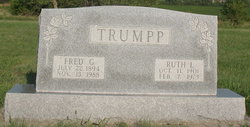
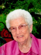
| Description | : | Arnold W. Trumpp, age 92 of Clay Center, passed from his earthly life to his heavenly home on Tuesday, January 28, 2020 at the Clay County Medical Center. He was born on February 23, 1927 in Clay Center, the son of Fred G. and Ruth (Nauerth) Trumpp. On August 24, 1949 he was married to Wilma Jean Friederich at her family home in rural Clay Center. She preceded him in death on January 27, 2013. Arnold was a farmer. Following his retirement from the farm, he did custom woodworking. He loved spending time with his... Read More |
frequently asked questions (FAQ):
-
Where is Arnold W. Trumpp's memorial?
Arnold W. Trumpp's memorial is located at: Ebenezer Cemetery, Green, Clay County, USA.
-
When did Arnold W. Trumpp death?
Arnold W. Trumpp death on 28 Jan 2020 in Clay Center, Clay County, Kansas, USA
-
Where are the coordinates of the Arnold W. Trumpp's memorial?
Latitude: 39.3866997
Longitude: -96.9974976
Family Members:
Parent

Spouse
Siblings

Flowers:


Nearby Cemetories:
1. Ebenezer Cemetery
Green, Clay County, USA
Coordinate: 39.3866997, -96.9974976
2. Green Cemetery
Green, Clay County, USA
Coordinate: 39.4235992, -96.9882965
3. Lasita Cemetery
Leonardville, Riley County, USA
Coordinate: 39.4092900, -96.9422900
4. Clay County Poor Farm Cemetery
Clay Center, Clay County, USA
Coordinate: 39.3772700, -97.0727000
5. Pleasant Hill Cemetery
Leonardville, Riley County, USA
Coordinate: 39.4371210, -96.9426730
6. Broughton Cemetery
Clay Center, Clay County, USA
Coordinate: 39.3306007, -97.0535965
7. Fancy Creek Cemetery
Green, Clay County, USA
Coordinate: 39.4668999, -96.9969025
8. Hayes Cemetery
Clay County, USA
Coordinate: 39.4516983, -97.0811005
9. Bala Cemetery
Bala, Riley County, USA
Coordinate: 39.3053017, -96.9341965
10. Saint Peter and Saint Pauls Catholic Cemetery
Clay Center, Clay County, USA
Coordinate: 39.4005450, -97.1236680
11. Brethren in Christ Cemetery
Clay County, USA
Coordinate: 39.4810982, -97.0344009
12. Greenwood Cemetery
Clay Center, Clay County, USA
Coordinate: 39.4011002, -97.1275024
13. Leonardville Cemetery
Leonardville, Riley County, USA
Coordinate: 39.3792000, -96.8589020
14. Gilbert Cemetery
Clay County, USA
Coordinate: 39.2853012, -97.0625000
15. Milo Chapman Gravesite
Broughton, Clay County, USA
Coordinate: 39.2888500, -97.0724400
16. Gatesville Cemetery
Wakefield, Clay County, USA
Coordinate: 39.2721460, -97.0041380
17. Leonardville United Methodist Cemetery
Leonardville, Riley County, USA
Coordinate: 39.3568700, -96.8493600
18. May Day Cemetery
Center Township, Riley County, USA
Coordinate: 39.4958000, -96.9302979
19. Goshen Central Cemetery
Clay Center, Clay County, USA
Coordinate: 39.5099983, -97.0160980
20. Joseph Sender Family Cemetery
Clay County, USA
Coordinate: 39.5090600, -97.0348800
21. Crooked Creek Cemetery
Randolph, Riley County, USA
Coordinate: 39.4369011, -96.8480988
22. Swedish Pleasant Hill Cemetery
Clay Center, Clay County, USA
Coordinate: 39.4735985, -97.1268997
23. Republican City Cemetery
Clay Center, Clay County, USA
Coordinate: 39.3431015, -97.1628036
24. Idylwilde Cemetery
Clay Center, Clay County, USA
Coordinate: 39.5097900, -97.0713000