
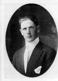
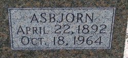

Asbjorn Christofferson “Ben” Morch
| Birth | : | 22 Apr 1892 Horten, Horten kommune, Vestfold fylke, Norway |
| Death | : | 18 Oct 1964 Postville, Allamakee County, Iowa, USA |
| Burial | : | Tracy Public Cemetery, Tracy, San Joaquin County, USA |
| Coordinate | : | 37.7251358, -121.4189453 |
| Description | : | ASBJORN(BEN)MORCH received his education in the public school in Horton,Norway, and accepted a position with the Government Telegraph and Telephone Station on June 1,1907, working in that position until February 28,1909. He sailed for America on March 12,1909, at the age of 16 years on a ship named HOLY OLAF. Two persons said it cost his dad $100 or more. He landed in America on March 24, 1909 and continued his journey to Elgin,Iowa to the Ole Peterson Farm, where he engaged in farm work. He became a naturalized citizen in Clayton county on April 2, 1918. On July 26,1918 he entered the... Read More |
frequently asked questions (FAQ):
-
Where is Asbjorn Christofferson “Ben” Morch's memorial?
Asbjorn Christofferson “Ben” Morch's memorial is located at: Tracy Public Cemetery, Tracy, San Joaquin County, USA.
-
When did Asbjorn Christofferson “Ben” Morch death?
Asbjorn Christofferson “Ben” Morch death on 18 Oct 1964 in Postville, Allamakee County, Iowa, USA
-
Where are the coordinates of the Asbjorn Christofferson “Ben” Morch's memorial?
Latitude: 37.7251358
Longitude: -121.4189453
Family Members:
Spouse
Children
Flowers:


Nearby Cemetories:
1. Tracy Public Cemetery
Tracy, San Joaquin County, USA
Coordinate: 37.7251358, -121.4189453
2. Tracy Mausoleum
Tracy, San Joaquin County, USA
Coordinate: 37.7250214, -121.4150696
3. Valpico Memorial Park
Tracy, San Joaquin County, USA
Coordinate: 37.7113260, -121.4656510
4. Brichetto Tomb
San Joaquin County, USA
Coordinate: 37.6272011, -121.3871994
5. East Union Cemetery
Manteca, San Joaquin County, USA
Coordinate: 37.8114014, -121.2350006
6. Congregation of Ahavas Achim Cemetery
French Camp, San Joaquin County, USA
Coordinate: 37.8778419, -121.2753067
7. Chinese Cemetery
French Camp, San Joaquin County, USA
Coordinate: 37.8819962, -121.2805862
8. Congregation Adas Yeshuran of Stockton Cemetery
French Camp, San Joaquin County, USA
Coordinate: 37.8784065, -121.2740784
9. Park View Cemetery
Manteca, San Joaquin County, USA
Coordinate: 37.8617249, -121.2238312
10. Five Pillars Farm Cemetery
Livermore, Alameda County, USA
Coordinate: 37.7262764, -121.7105789
11. Ripon Cemetery
Ripon, San Joaquin County, USA
Coordinate: 37.7420311, -121.1238708
12. Atlanta Cemetery
Five Corners, San Joaquin County, USA
Coordinate: 37.8270035, -121.1420135
13. Grayson Cemetery
Grayson, Stanislaus County, USA
Coordinate: 37.5594559, -121.1802826
14. Thomas Lindsay Gravesite
San Joaquin County, USA
Coordinate: 37.9573110, -121.2918430
15. David Kelsey Gravesite
Stockton, San Joaquin County, USA
Coordinate: 37.9573110, -121.2918430
16. Citizens Cemetery
Stockton, San Joaquin County, USA
Coordinate: 37.9559410, -121.2769120
17. Union Cemetery
Brentwood, Contra Costa County, USA
Coordinate: 37.9103012, -121.6477966
18. Temple Israel Cemetery
Stockton, San Joaquin County, USA
Coordinate: 37.9640541, -121.2784348
19. Stockton State Hospital Cemetery
Stockton, San Joaquin County, USA
Coordinate: 37.9663110, -121.2846850
20. Saint Michaels Cemetery
Livermore, Alameda County, USA
Coordinate: 37.6797790, -121.7519150
21. San Joaquin Catholic Cemetery
Stockton, San Joaquin County, USA
Coordinate: 37.9707830, -121.2850190
22. IOOF Memory Gardens Cemetery
Livermore, Alameda County, USA
Coordinate: 37.6797850, -121.7526100
23. Casa Bonita Mausoleum
Stockton, San Joaquin County, USA
Coordinate: 37.9752340, -121.2877800
24. Stockton Woodland Mausoleum
Stockton, San Joaquin County, USA
Coordinate: 37.9762400, -121.2878000