
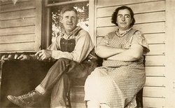
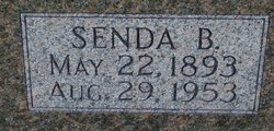
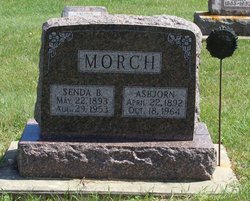
Senda Bertha Gericke Morch
| Birth | : | 22 May 1893 USA |
| Death | : | 29 Aug 1953 Postville, Allamakee County, Iowa, USA |
| Burial | : | Tracy Public Cemetery, Tracy, San Joaquin County, USA |
| Coordinate | : | 37.7251358, -121.4189453 |
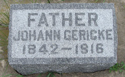
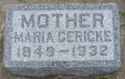
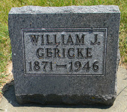
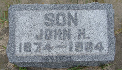
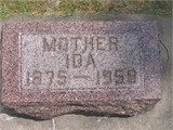
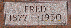
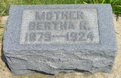
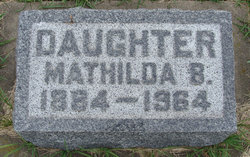
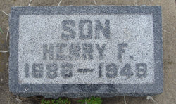
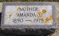
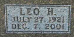
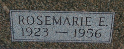
| Description | : | Born to parents: Johanne Gericke and Maria Geborn Klinge. Baptized: 27 Aug. 1893. Confirmed: 12 Apr. 1908 Rev.R.Kuhne Married: 21 Jan.1919 to Asbjorn "Ben" Morch of Postville, in St.Pauls Evangelical Lutheran Chruch, Postville, Allamakee Co.,Iowa. She is survived by her husband and four children, (Jeleen) Mrs. Millard Bilden of Postville, Leo Morch of Postville, (Rosemarie), Mrs. Walter Foels of Decorah and Herbert at home; 13 grandchildren; one brother, John Gericke, of Postville; four sisters, Mrs. Ida Meyer, Mrs. Otto Sander, Mathilda Gericke and Mrs. Amanda Sebastian. She was preceded in death by her parents, three brothers, William, Fred and Henry Gericke and one sister (Bertha)... Read More |
frequently asked questions (FAQ):
-
Where is Senda Bertha Gericke Morch's memorial?
Senda Bertha Gericke Morch's memorial is located at: Tracy Public Cemetery, Tracy, San Joaquin County, USA.
-
When did Senda Bertha Gericke Morch death?
Senda Bertha Gericke Morch death on 29 Aug 1953 in Postville, Allamakee County, Iowa, USA
-
Where are the coordinates of the Senda Bertha Gericke Morch's memorial?
Latitude: 37.7251358
Longitude: -121.4189453
Family Members:
Parent
Spouse
Siblings
Children
Flowers:


Nearby Cemetories:
1. Tracy Public Cemetery
Tracy, San Joaquin County, USA
Coordinate: 37.7251358, -121.4189453
2. Tracy Mausoleum
Tracy, San Joaquin County, USA
Coordinate: 37.7250214, -121.4150696
3. Valpico Memorial Park
Tracy, San Joaquin County, USA
Coordinate: 37.7113260, -121.4656510
4. Brichetto Tomb
San Joaquin County, USA
Coordinate: 37.6272011, -121.3871994
5. East Union Cemetery
Manteca, San Joaquin County, USA
Coordinate: 37.8114014, -121.2350006
6. Congregation of Ahavas Achim Cemetery
French Camp, San Joaquin County, USA
Coordinate: 37.8778419, -121.2753067
7. Chinese Cemetery
French Camp, San Joaquin County, USA
Coordinate: 37.8819962, -121.2805862
8. Congregation Adas Yeshuran of Stockton Cemetery
French Camp, San Joaquin County, USA
Coordinate: 37.8784065, -121.2740784
9. Park View Cemetery
Manteca, San Joaquin County, USA
Coordinate: 37.8617249, -121.2238312
10. Five Pillars Farm Cemetery
Livermore, Alameda County, USA
Coordinate: 37.7262764, -121.7105789
11. Ripon Cemetery
Ripon, San Joaquin County, USA
Coordinate: 37.7420311, -121.1238708
12. Atlanta Cemetery
Five Corners, San Joaquin County, USA
Coordinate: 37.8270035, -121.1420135
13. Grayson Cemetery
Grayson, Stanislaus County, USA
Coordinate: 37.5594559, -121.1802826
14. Thomas Lindsay Gravesite
San Joaquin County, USA
Coordinate: 37.9573110, -121.2918430
15. David Kelsey Gravesite
Stockton, San Joaquin County, USA
Coordinate: 37.9573110, -121.2918430
16. Citizens Cemetery
Stockton, San Joaquin County, USA
Coordinate: 37.9559410, -121.2769120
17. Union Cemetery
Brentwood, Contra Costa County, USA
Coordinate: 37.9103012, -121.6477966
18. Temple Israel Cemetery
Stockton, San Joaquin County, USA
Coordinate: 37.9640541, -121.2784348
19. Stockton State Hospital Cemetery
Stockton, San Joaquin County, USA
Coordinate: 37.9663110, -121.2846850
20. Saint Michaels Cemetery
Livermore, Alameda County, USA
Coordinate: 37.6797790, -121.7519150
21. San Joaquin Catholic Cemetery
Stockton, San Joaquin County, USA
Coordinate: 37.9707830, -121.2850190
22. IOOF Memory Gardens Cemetery
Livermore, Alameda County, USA
Coordinate: 37.6797850, -121.7526100
23. Casa Bonita Mausoleum
Stockton, San Joaquin County, USA
Coordinate: 37.9752340, -121.2877800
24. Stockton Woodland Mausoleum
Stockton, San Joaquin County, USA
Coordinate: 37.9762400, -121.2878000