

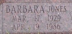
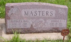
Barbara Ruth Jones Masters
| Birth | : | 17 Mar 1929 Burlingame, Osage County, Kansas, USA |
| Death | : | 19 Apr 1986 Burlingame, Osage County, Kansas, USA |
| Burial | : | Riverside Cemetery, Plymouth, Grafton County, USA |
| Coordinate | : | 43.7736000, -71.6908100 |
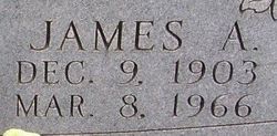
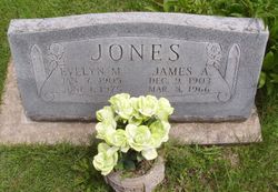
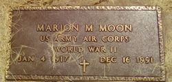
| Description | : | Married Marion Merle Moon on 9 Aug 1947 In Kansas, United States Married: Sept 12, 1959 to George F. |
frequently asked questions (FAQ):
-
Where is Barbara Ruth Jones Masters's memorial?
Barbara Ruth Jones Masters's memorial is located at: Riverside Cemetery, Plymouth, Grafton County, USA.
-
When did Barbara Ruth Jones Masters death?
Barbara Ruth Jones Masters death on 19 Apr 1986 in Burlingame, Osage County, Kansas, USA
-
Where are the coordinates of the Barbara Ruth Jones Masters's memorial?
Latitude: 43.7736000
Longitude: -71.6908100
Family Members:
Parent
Spouse
Siblings

Flowers:


Nearby Cemetories:
1. Riverside Cemetery
Plymouth, Grafton County, USA
Coordinate: 43.7736000, -71.6908100
2. Trinity Churchyard Cemetery
Holderness, Grafton County, USA
Coordinate: 43.7566000, -71.6696700
3. Dearborn Cemetery
Plymouth, Grafton County, USA
Coordinate: 43.7597220, -71.7213890
4. Beech Hill Burying Ground
Campton, Grafton County, USA
Coordinate: 43.8000620, -71.7119690
5. Pleasant Valley Cemetery
Plymouth, Grafton County, USA
Coordinate: 43.7741300, -71.7364600
6. Church Hill Cemetery
Ashland, Grafton County, USA
Coordinate: 43.7455560, -71.6522220
7. Spencer Cemetery
Grafton County, USA
Coordinate: 43.7720080, -71.7455500
8. Calvary Independent Baptist Church Cemetery
Plymouth, Grafton County, USA
Coordinate: 43.7639220, -71.7484290
9. Bartlett Cemetery
Plymouth, Grafton County, USA
Coordinate: 43.7542400, -71.7436200
10. Blair Cemetery
Campton, Grafton County, USA
Coordinate: 43.8111000, -71.6603012
11. Lower Intervale Cemetery
Plymouth, Grafton County, USA
Coordinate: 43.7316100, -71.6733800
12. Bog Road Cemetery
Campton, Grafton County, USA
Coordinate: 43.8152149, -71.6666793
13. Blaisdell Cemetery
Campton, Grafton County, USA
Coordinate: 43.8169440, -71.6555560
14. Turnpike Cemetery
Plymouth, Grafton County, USA
Coordinate: 43.7492700, -71.7532800
15. Shaw Cemetery
Holderness, Grafton County, USA
Coordinate: 43.7436110, -71.6225000
16. Owl Brook Cemetery
Ashland, Grafton County, USA
Coordinate: 43.7333200, -71.6300100
17. Campton Hollow Cemetery
Campton Hollow, Grafton County, USA
Coordinate: 43.8238150, -71.6409440
18. Hicks Hill Cemetery
Ashland, Grafton County, USA
Coordinate: 43.7277780, -71.6313890
19. Sanborn Cemetery
Holderness, Grafton County, USA
Coordinate: 43.7612800, -71.6050600
20. East Rumney
Rumney, Grafton County, USA
Coordinate: 43.8236110, -71.7483330
21. Union Cemetery
Bridgewater, Grafton County, USA
Coordinate: 43.7093500, -71.6763500
22. Mitchell Family Cemetery
Bridgewater, Grafton County, USA
Coordinate: 43.7052780, -71.6838890
23. Partridge Hill Cemetery
West Campton, Grafton County, USA
Coordinate: 43.8428700, -71.7046900
24. Eastern Corner Road Cemetery
Campton, Grafton County, USA
Coordinate: 43.8177540, -71.6045920