


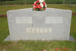
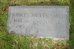
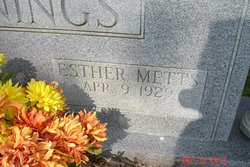
Beatrice Metts Turner
| Birth | : | 27 Jul 1927 Branchville, Orangeburg County, South Carolina, USA |
| Death | : | 1 Oct 2014 Orangeburg, Orangeburg County, South Carolina, USA |
| Burial | : | Taruheru Cemetery, Gisborne, Gisborne District, New Zealand |
| Coordinate | : | -38.6428900, 177.9802300 |
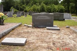
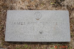
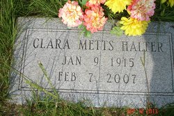
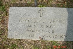
| Description | : | Branchville Beatrice Metts Turner, 87 years of age, died October 1, 2014. Mrs. Turner was born in Branchville, a daughter of the late Clarence M. Metts and Fannie Idella Walters Metts. She was a member of the Branchville Baptist Church. She was a nurse at Providence Hospital in Columbia, Manor Care Nursing Home, and Bowman Public School System. She was the widow of the late James Roy Turner Sr. and has been a member of the Branchville community for the past 18 years. Funeral services will be conducted Saturday, October 4, 2014, at 11:00 A.M. at the chapel... Read More |
frequently asked questions (FAQ):
-
Where is Beatrice Metts Turner's memorial?
Beatrice Metts Turner's memorial is located at: Taruheru Cemetery, Gisborne, Gisborne District, New Zealand.
-
When did Beatrice Metts Turner death?
Beatrice Metts Turner death on 1 Oct 2014 in Orangeburg, Orangeburg County, South Carolina, USA
-
Where are the coordinates of the Beatrice Metts Turner's memorial?
Latitude: -38.6428900
Longitude: 177.9802300
Family Members:
Parent


Spouse
Siblings


Flowers:


Nearby Cemetories:
1. Taruheru Cemetery
Gisborne, Gisborne District, New Zealand
Coordinate: -38.6428900, 177.9802300
2. Makaraka Cemetery
Gisborne, Gisborne District, New Zealand
Coordinate: -38.6482600, 177.9803200
3. Waerenga a hika Urupā
Gisborne, Gisborne District, New Zealand
Coordinate: -38.5954100, 177.9263500
4. Opou Tuarakena Cemetery
Manutuke, Gisborne District, New Zealand
Coordinate: -38.6744759, 177.9095277
5. Opou Station Cemetery
Manutuke, Gisborne District, New Zealand
Coordinate: -38.6779310, 177.9084450
6. Paramanihi Waihirere Cemetery
Gisborne, Gisborne District, New Zealand
Coordinate: -38.5791250, 177.9488450
7. Manutuke Churchyard Urupā
Manutuke, Gisborne District, New Zealand
Coordinate: -38.6815360, 177.9080180
8. Patutahi Cemetery
Gisborne, Gisborne District, New Zealand
Coordinate: -38.6199300, 177.8955600
9. Manutuke Whakato Urupā
Manutuke, Gisborne District, New Zealand
Coordinate: -38.6843390, 177.9073690
10. Wainui
Gisborne District, New Zealand
Coordinate: -38.6950000, 178.0707400
11. Ormond Cemetery
Ormond, Gisborne District, New Zealand
Coordinate: -38.5526480, 177.9279330
12. Pouawa Urupā
Whangara, Gisborne District, New Zealand
Coordinate: -38.6085500, 178.1825900
13. Whangara Urupā
Whangara, Gisborne District, New Zealand
Coordinate: -38.5716800, 178.2310400
14. Tapuae o te Rangi Urupā
Whatatutu, Gisborne District, New Zealand
Coordinate: -38.3791200, 177.8134180
15. Kohimarama Urupā
Tolaga Bay, Gisborne District, New Zealand
Coordinate: -38.3791770, 178.3007610
16. Nuhaka North Cemetery
Morere, Wairoa District, New Zealand
Coordinate: -38.9797100, 177.7944300
17. Tolaga Bay Cemetery
Tolaga Bay, Gisborne District, New Zealand
Coordinate: -38.3643370, 178.3045240
18. Tolaga Bay Urupā
Tolaga Bay, Gisborne District, New Zealand
Coordinate: -38.3629400, 178.3050080
19. Rakauroa Cemetery
Matawai, Gisborne District, New Zealand
Coordinate: -38.4358900, 177.5711400
20. Okuri Marea Urupa
Tolaga Bay, Gisborne District, New Zealand
Coordinate: -38.3055250, 178.2704340
21. Arataiha Urupā
Nuhaka, Wairoa District, New Zealand
Coordinate: -39.0201020, 177.7361770
22. Opoutama Cemetery
Mahia, Wairoa District, New Zealand
Coordinate: -39.0550780, 177.8405420
23. Manawarakau Urupā
Nuhaka, Wairoa District, New Zealand
Coordinate: -39.0371870, 177.7262650
24. Kaiuku Marae Urupā
Mahia, Wairoa District, New Zealand
Coordinate: -39.0823112, 177.9086516