
Bershebe Smith
| Birth | : | 5 Jan 1709 Chatham, Barnstable County, Massachusetts, USA |
| Death | : | 16 Jan 1766 Chatham, Barnstable County, Massachusetts, USA |
| Burial | : | Davids Cemetery, Kettering, Montgomery County, USA |
| Coordinate | : | 39.6789017, -84.1697006 |
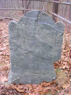
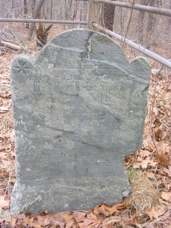
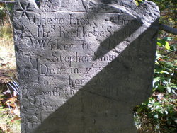
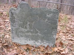
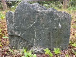
| Inscription | : | Here Lies buried Mrs Bershebe Smith Widow to Mr Stephen Smith who Dec'd in ye 57th year of her Age with the Small pox She Dec'd Jan'ry 16th 1766 |
| Description | : | dau of Stephen & Bershebe age 22∼age 57 *** note biographical error in spouse name. Bershebe or Bathsheba (aka Barbary) Brown was the daughter of George Brown and Elizabeth Mulford, born in Eastham. She was the second wife of George Smith, married 9 Apr 1729. She was baptized as an adult adult 17 Mar 1741 at Chatham. Her husband Stephen Smith was elected Deacon 6 Sep 1749. She died with her husband and daughter during the 1766 Smallpox epidemic and is buried in the woods south of Old Comer's Rd in Chatham commonly... Read More |
frequently asked questions (FAQ):
-
Where is Bershebe Smith's memorial?
Bershebe Smith's memorial is located at: Davids Cemetery, Kettering, Montgomery County, USA.
-
When did Bershebe Smith death?
Bershebe Smith death on 16 Jan 1766 in Chatham, Barnstable County, Massachusetts, USA
-
Where are the coordinates of the Bershebe Smith's memorial?
Latitude: 39.6789017
Longitude: -84.1697006
Family Members:
Spouse
Children

Flowers:


Nearby Cemetories:
1. Saint Georges Episcopal Church Memorial Garden
Dayton, Montgomery County, USA
Coordinate: 39.6672760, -84.1608950
2. Woodbourne Cemetery
Montgomery County, USA
Coordinate: 39.6588783, -84.1727676
3. Epiphanys Lutheran Memorial Garden
Dayton, Montgomery County, USA
Coordinate: 39.6510760, -84.1548340
4. Zion Cemetery
Moraine, Montgomery County, USA
Coordinate: 39.6931877, -84.2118378
5. Munger Road Cemetery
Centerville, Montgomery County, USA
Coordinate: 39.6556220, -84.2048980
6. Beavertown Cemetery
Beavertown, Montgomery County, USA
Coordinate: 39.6981010, -84.1288986
7. Sugar Creek Baptist Church Cemetery
Centerville, Montgomery County, USA
Coordinate: 39.6367493, -84.1579666
8. Saint Paul's Episcopal Church Columbarium
Oakwood, Montgomery County, USA
Coordinate: 39.7249780, -84.1747480
9. Centerville Cemetery
Centerville, Montgomery County, USA
Coordinate: 39.6307983, -84.1539001
10. Calvary Cemetery
Dayton, Montgomery County, USA
Coordinate: 39.7248993, -84.1979980
11. McLane Cemetery
Beavercreek, Greene County, USA
Coordinate: 39.6735916, -84.1019592
12. Beth Abraham Cemetery
Oakwood, Montgomery County, USA
Coordinate: 39.7291985, -84.1919022
13. Washington Cemetery
Montgomery County, USA
Coordinate: 39.6332000, -84.2060300
14. Riverview Cemetery
Dayton, Montgomery County, USA
Coordinate: 39.7299995, -84.1908035
15. Morgan Cemetery
Kettering, Montgomery County, USA
Coordinate: 39.7033830, -84.1067830
16. Marianist Brothers Cemetery
Dayton, Montgomery County, USA
Coordinate: 39.7385700, -84.1733500
17. Sugar Creek Friends Cemetery
Centerville, Montgomery County, USA
Coordinate: 39.6204681, -84.1393509
18. Woodland Cemetery and Arboretum
Dayton, Montgomery County, USA
Coordinate: 39.7428840, -84.1773210
19. Queen of Heaven Cemetery
Beavercreek, Greene County, USA
Coordinate: 39.7176730, -84.0992720
20. Fallis Pioneer Cemetery
Bellbrook, Greene County, USA
Coordinate: 39.6553690, -84.0881860
21. Old Greencastle Cemetery
Dayton, Montgomery County, USA
Coordinate: 39.7370000, -84.2143900
22. Saint Henrys Cemetery
Dayton, Montgomery County, USA
Coordinate: 39.7450150, -84.1887630
23. Evergreen Cemetery
West Carrollton City, Montgomery County, USA
Coordinate: 39.6744003, -84.2585983
24. New Greencastle Cemetery
Dayton, Montgomery County, USA
Coordinate: 39.7346992, -84.2272034