
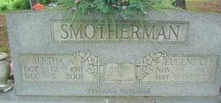
Bertha A. Copper Bradford
| Birth | : | 12 Oct 1911 Oregon County, Missouri, USA |
| Death | : | 5 Dec 2001 West Plains, Howell County, Missouri, USA |
| Burial | : | Crouseville Cemetery, Crouseville, Aroostook County, USA |
| Coordinate | : | 46.7574997, -68.0768967 |
| Inscription | : | Married Apr. 22, 1985. Precious Memories |
| Description | : | Bertha A. Copper Smotherman Bradford, the daughter of Jesse and Dora M. (Toelke) Cooper. She married Gene Smotherman and had one son. Gene preceded her in death on May 1, 1975. Bertha later married Walter Bradford who preceded her in death on Jan. 3, 2001. Her son, Troy; her parents; four brothers and one sister also preceded her in death. She is survived by one grandson, Randy Smotherman; two grandchildren, Ludia and Jimmy; one sister, Beulah Dorman. |
frequently asked questions (FAQ):
-
Where is Bertha A. Copper Bradford's memorial?
Bertha A. Copper Bradford's memorial is located at: Crouseville Cemetery, Crouseville, Aroostook County, USA.
-
When did Bertha A. Copper Bradford death?
Bertha A. Copper Bradford death on 5 Dec 2001 in West Plains, Howell County, Missouri, USA
-
Where are the coordinates of the Bertha A. Copper Bradford's memorial?
Latitude: 46.7574997
Longitude: -68.0768967
Family Members:
Parent
Spouse

Siblings
Children
Flowers:

Left by Anonymous on 08 Mar 2007

Left by Anonymous on 13 Nov 2007

Left by Anonymous on 02 Apr 2008

Left by Anonymous on 30 Jan 2010

Left by Anonymous on 30 Jan 2010

Left by Anonymous on 24 Mar 2010

my first teacher.And such a great one.I will never forget you.
Left by Anonymous on 02 Jun 2013

An apple for the teacher!
Left by Anonymous on 30 Jul 2021


Nearby Cemetories:
1. Crouseville Cemetery
Crouseville, Aroostook County, USA
Coordinate: 46.7574997, -68.0768967
2. Hillside Grove Cemetery
Crouseville, Aroostook County, USA
Coordinate: 46.7566760, -68.0765500
3. Washburn Riverside Extension Cemetery
Washburn, Aroostook County, USA
Coordinate: 46.7750816, -68.1517105
4. Riverside Cemetery
Washburn, Aroostook County, USA
Coordinate: 46.7785492, -68.1552277
5. Johnson Cemetery
Presque Isle, Aroostook County, USA
Coordinate: 46.7078209, -68.0069733
6. Lyndon Center Cemetery
Caribou, Aroostook County, USA
Coordinate: 46.8022240, -67.9921920
7. Castle Hill Cemetery
Castle Hill, Aroostook County, USA
Coordinate: 46.7346840, -68.1792210
8. Saint Marys Cemetery
Presque Isle, Aroostook County, USA
Coordinate: 46.6930930, -68.0104730
9. Bean Family Cemetery
Aroostook County, USA
Coordinate: 46.7396440, -67.9542600
10. Thompson Burial Ground
Caribou, Aroostook County, USA
Coordinate: 46.8143280, -67.9821140
11. Saint Marys Chapman Street Cemetery
Presque Isle, Aroostook County, USA
Coordinate: 46.6754150, -68.0215990
12. Old Mill Town Cemetery
Mapleton, Aroostook County, USA
Coordinate: 46.6815700, -68.1609100
13. Reuben Bean Family Cemetery
Aroostook County, USA
Coordinate: 46.7141610, -67.9514610
14. Northern Maine Veterans Cemetery
Caribou, Aroostook County, USA
Coordinate: 46.8512400, -68.0428500
15. Bartlett Cemetery
Presque Isle, Aroostook County, USA
Coordinate: 46.6765327, -67.9827118
16. Evergreen Cemetery
Caribou, Aroostook County, USA
Coordinate: 46.8524500, -68.0112700
17. Greenridge Cemetery
Caribou, Aroostook County, USA
Coordinate: 46.7923622, -67.9321976
18. Fairmount Cemetery
Presque Isle, Aroostook County, USA
Coordinate: 46.6628075, -68.0077744
19. Holy Rosary Cemetery Old
Caribou, Aroostook County, USA
Coordinate: 46.8558510, -68.0046860
20. Southside Cemetery
Mapleton, Aroostook County, USA
Coordinate: 46.6622050, -68.1633620
21. Bubar Cemetery
Aroostook County, USA
Coordinate: 46.8399970, -67.9447840
22. Cochran Cemetery
Caribou, Aroostook County, USA
Coordinate: 46.8672220, -67.9902780
23. Grimes Cemetery
Caribou, Aroostook County, USA
Coordinate: 46.8440386, -67.9420385
24. Grendell Cemetery
Chapman, Aroostook County, USA
Coordinate: 46.6364010, -68.1318340