

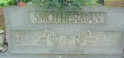
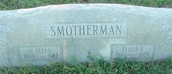
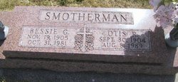
Eugene Cecil Smotherman
| Birth | : | 6 Nov 1909 Shannon County, Missouri, USA |
| Death | : | 1 May 1975 Birch Tree, Shannon County, Missouri, USA |
| Burial | : | Crouseville Cemetery, Crouseville, Aroostook County, USA |
| Coordinate | : | 46.7574997, -68.0768967 |
| Inscription | : | Married Apr. 22, 1985. Precious Memories |
| Description | : | Eugene Cecil Smotherman in the U.S., World War II Draft Cards Young Men, 1940-1947 Name: Eugene Cecil Smotherman Gender: Male Race: White Age: 31 Relationship to Draftee: Self (Head) Birth Date: 6 Nov 1909 Birth Place: Shannon, Missouri, USA Residence Place: Birch Tree, Shannon, Missouri, USA Registration Date: 15 Nov 1940 Registration Place: Birch Tree, Shannon, Missouri, USA Employer: Self Height: 5 8 Weight: 136 Complexion: Dark Hair Color: Brown Eye Color: Brown Next of Kin: Bertha Adelia Smotherman Household Members Age Relationship Eugene Cecil Smotherman 31 Self (Head) Bertha Adelia Smotherman Wife |
frequently asked questions (FAQ):
-
Where is Eugene Cecil Smotherman's memorial?
Eugene Cecil Smotherman's memorial is located at: Crouseville Cemetery, Crouseville, Aroostook County, USA.
-
When did Eugene Cecil Smotherman death?
Eugene Cecil Smotherman death on 1 May 1975 in Birch Tree, Shannon County, Missouri, USA
-
Where are the coordinates of the Eugene Cecil Smotherman's memorial?
Latitude: 46.7574997
Longitude: -68.0768967
Family Members:
Parent
Spouse
Siblings

Children


Nearby Cemetories:
1. Crouseville Cemetery
Crouseville, Aroostook County, USA
Coordinate: 46.7574997, -68.0768967
2. Hillside Grove Cemetery
Crouseville, Aroostook County, USA
Coordinate: 46.7566760, -68.0765500
3. Washburn Riverside Extension Cemetery
Washburn, Aroostook County, USA
Coordinate: 46.7750816, -68.1517105
4. Riverside Cemetery
Washburn, Aroostook County, USA
Coordinate: 46.7785492, -68.1552277
5. Johnson Cemetery
Presque Isle, Aroostook County, USA
Coordinate: 46.7078209, -68.0069733
6. Lyndon Center Cemetery
Caribou, Aroostook County, USA
Coordinate: 46.8022240, -67.9921920
7. Castle Hill Cemetery
Castle Hill, Aroostook County, USA
Coordinate: 46.7346840, -68.1792210
8. Saint Marys Cemetery
Presque Isle, Aroostook County, USA
Coordinate: 46.6930930, -68.0104730
9. Bean Family Cemetery
Aroostook County, USA
Coordinate: 46.7396440, -67.9542600
10. Thompson Burial Ground
Caribou, Aroostook County, USA
Coordinate: 46.8143280, -67.9821140
11. Saint Marys Chapman Street Cemetery
Presque Isle, Aroostook County, USA
Coordinate: 46.6754150, -68.0215990
12. Old Mill Town Cemetery
Mapleton, Aroostook County, USA
Coordinate: 46.6815700, -68.1609100
13. Reuben Bean Family Cemetery
Aroostook County, USA
Coordinate: 46.7141610, -67.9514610
14. Northern Maine Veterans Cemetery
Caribou, Aroostook County, USA
Coordinate: 46.8512400, -68.0428500
15. Bartlett Cemetery
Presque Isle, Aroostook County, USA
Coordinate: 46.6765327, -67.9827118
16. Evergreen Cemetery
Caribou, Aroostook County, USA
Coordinate: 46.8524500, -68.0112700
17. Greenridge Cemetery
Caribou, Aroostook County, USA
Coordinate: 46.7923622, -67.9321976
18. Fairmount Cemetery
Presque Isle, Aroostook County, USA
Coordinate: 46.6628075, -68.0077744
19. Holy Rosary Cemetery Old
Caribou, Aroostook County, USA
Coordinate: 46.8558510, -68.0046860
20. Southside Cemetery
Mapleton, Aroostook County, USA
Coordinate: 46.6622050, -68.1633620
21. Bubar Cemetery
Aroostook County, USA
Coordinate: 46.8399970, -67.9447840
22. Cochran Cemetery
Caribou, Aroostook County, USA
Coordinate: 46.8672220, -67.9902780
23. Grimes Cemetery
Caribou, Aroostook County, USA
Coordinate: 46.8440386, -67.9420385
24. Grendell Cemetery
Chapman, Aroostook County, USA
Coordinate: 46.6364010, -68.1318340