
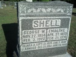
| Birth | : | 30 Nov 1886 |
| Death | : | 21 Nov 1967 |
| Burial | : | Big Spring Presbyterian Church Cemetery, Friendsville, Blount County, USA |
| Coordinate | : | 35.7271996, -84.1027985 |
frequently asked questions (FAQ):
-
Where is Bertha Emaline Shell Leister's memorial?
Bertha Emaline Shell Leister's memorial is located at: Big Spring Presbyterian Church Cemetery, Friendsville, Blount County, USA.
-
When did Bertha Emaline Shell Leister death?
Bertha Emaline Shell Leister death on 21 Nov 1967 in
-
Where are the coordinates of the Bertha Emaline Shell Leister's memorial?
Latitude: 35.7271996
Longitude: -84.1027985
Family Members:
Parent

Spouse

Siblings

Children
Flowers:


Nearby Cemetories:
1. Big Spring Presbyterian Church Cemetery
Friendsville, Blount County, USA
Coordinate: 35.7271996, -84.1027985
2. Parkins Family Cemetery
Blount County, USA
Coordinate: 35.7401800, -84.1164000
3. Union Grove Methodist Cemetery
Friendsville, Blount County, USA
Coordinate: 35.7531000, -84.0931000
4. Salem Baptist Church Cemetery
Blount County, USA
Coordinate: 35.6982994, -84.1014023
5. Marble Hill Missionary Baptist Church Cemetery
Friendsville, Blount County, USA
Coordinate: 35.7187770, -84.1406850
6. Clover Hill Cemetery
Blount County, USA
Coordinate: 35.7127991, -84.0607986
7. Friends Meeting House and Cemetery
Friendsville, Blount County, USA
Coordinate: 35.7612991, -84.1373978
8. Rescue Baptist Church Cemetery
Friendsville, Blount County, USA
Coordinate: 35.7724200, -84.0962700
9. Shady Grove Cemetery
Miser Station, Blount County, USA
Coordinate: 35.7738991, -84.0858002
10. Hopewell Cemetery
Maryville, Blount County, USA
Coordinate: 35.7083015, -84.0475006
11. Cloyds Creek Cemetery
Blount County, USA
Coordinate: 35.6981010, -84.1605988
12. Laurel Bank Baptist Church Cemetery
Friendsville, Blount County, USA
Coordinate: 35.7439003, -84.0357971
13. Bogle Farm Cemetery
Blount County, USA
Coordinate: 35.6708565, -84.0913239
14. Dotson Memorial Cemetery
Maryville, Blount County, USA
Coordinate: 35.7283478, -84.0315247
15. Mount Zion Baptist Church Cemetery
Maryville, Blount County, USA
Coordinate: 35.7698000, -84.0509900
16. Unitia Cemetery
Unitia, Loudon County, USA
Coordinate: 35.7491989, -84.1750031
17. Oakland Cemetery
Maryville, Blount County, USA
Coordinate: 35.6906013, -84.0397034
18. Friendship Baptist Church Cemetery
Maryville, Blount County, USA
Coordinate: 35.6926342, -84.0347026
19. Unitia Campground Cemetery
Loudon County, USA
Coordinate: 35.7484741, -84.1787415
20. Zion Chapel Cemetery
Louisville, Blount County, USA
Coordinate: 35.7963982, -84.1046982
21. Davis Cemetery
Blount County, USA
Coordinate: 35.7943993, -84.0817032
22. Leeper Cemetery
Loudon County, USA
Coordinate: 35.7607994, -84.1791992
23. Bakers Creek Cemetery
Blount County, USA
Coordinate: 35.6563988, -84.1100006
24. Hickory Valley Cemetery
Unitia, Loudon County, USA
Coordinate: 35.7409134, -84.1890564