

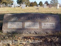
Bertha Goodwin King Williams
| Birth | : | 30 Oct 1886 Saint Lawrence, Hand County, South Dakota, USA |
| Death | : | 20 Oct 1959 Deadwood, Lawrence County, South Dakota, USA |
| Burial | : | Saint Lawrence Cemetery, Saint Lawrence, Hand County, USA |
| Coordinate | : | 44.5292015, -98.9321976 |
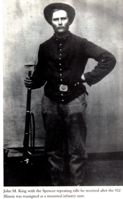
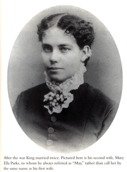
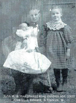
| Description | : | SD Birth Index: Birth Information for BERTHA KING (State File Number: 534309) File Date: 01/24/1941 Sex: F Birth Date: 10/30/1886 County: HAND Mother's Name: MAY PARKS Father's Name: JOHN KING *Stone engraved 1887. ------------------ Bertha was born October 30, 1886 in Hand Co., SD, the daughter of John M. and May E. (Parks) King of St. Lawrence. At age 3, she was allowed to live with her maternal grandmother, Julia (Holister) Parks in Ogle Co., Illinois to keep her cousin, Amy Weller company. Amy's mother, Emma (sister of Bertha's mother, May) had died, and the father couldn't care for Amy. Bertha continued to live with her grandmother, even after Amy... Read More |
frequently asked questions (FAQ):
-
Where is Bertha Goodwin King Williams's memorial?
Bertha Goodwin King Williams's memorial is located at: Saint Lawrence Cemetery, Saint Lawrence, Hand County, USA.
-
When did Bertha Goodwin King Williams death?
Bertha Goodwin King Williams death on 20 Oct 1959 in Deadwood, Lawrence County, South Dakota, USA
-
Where are the coordinates of the Bertha Goodwin King Williams's memorial?
Latitude: 44.5292015
Longitude: -98.9321976
Family Members:
Parent
Spouse
Siblings
Flowers:


Nearby Cemetories:
1. Saint Lawrence Cemetery
Saint Lawrence, Hand County, USA
Coordinate: 44.5292015, -98.9321976
2. Saint Ann's Cemetery
Miller, Hand County, USA
Coordinate: 44.5222015, -98.9732971
3. G A R Cemetery
Miller, Hand County, USA
Coordinate: 44.5078011, -98.9858017
4. Hillcrest Cemetery
Miller, Hand County, USA
Coordinate: 44.5207000, -99.0006100
5. Beulah Cemetery
Vayland, Hand County, USA
Coordinate: 44.6060982, -98.8060989
6. Sunbeam Cemetery
Hand County, USA
Coordinate: 44.6777992, -98.8407974
7. Saint Josephs Catholic Cemetery
Hand County, USA
Coordinate: 44.4574400, -98.7100400
8. Wessington Cemetery
Hand County, USA
Coordinate: 44.4569016, -98.7102966
9. Morningside Cemetery
Ree Heights, Hand County, USA
Coordinate: 44.5147018, -99.1903000
10. Alden Cemetery
Hand County, USA
Coordinate: 44.6775017, -99.1203003
11. Burdette Cemetery
Burdette, Hand County, USA
Coordinate: 44.7002983, -98.7869034
12. McCord Cemetery
Wessington, Beadle County, USA
Coordinate: 44.3998500, -98.6673100
13. Buffalo Cemetery
Spink County, USA
Coordinate: 44.6918983, -98.6853027
14. Howell Cemetery
Miller, Hand County, USA
Coordinate: 44.7757988, -98.9766998
15. Rosehill Cemetery
Hand County, USA
Coordinate: 44.2980995, -98.7731018
16. Saint Johns Cemetery
Tulare, Spink County, USA
Coordinate: 44.7202988, -98.6600037
17. Mount Calvary Cemetery
Polo, Hand County, USA
Coordinate: 44.7827988, -99.1097031
18. Sand Creek Cemetery
Beadle County, USA
Coordinate: 44.3055800, -98.6791200
19. Garfield Cemetery
Spink County, USA
Coordinate: 44.6622009, -98.5535965
20. Ebenezer Baptist Cemetery
Hand County, USA
Coordinate: 44.2106018, -98.9056015
21. Bonilla Cemetery
Bonilla, Beadle County, USA
Coordinate: 44.5830994, -98.4835968
22. Saint Michaels Cemetery
Hand County, USA
Coordinate: 44.8302994, -99.1106033
23. Cedar Cemetery
Hand County, USA
Coordinate: 44.2775002, -99.2238998
24. New Zion Cemetery
Hand County, USA
Coordinate: 44.2043991, -98.8206024