
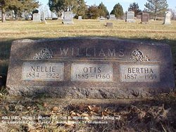
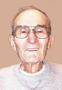
Otis Ora Williams
| Birth | : | 29 Aug 1885 Terre Haute, Vigo County, Indiana, USA |
| Death | : | 15 Aug 1960 Hand County, South Dakota, USA |
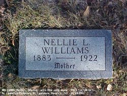
| Burial | : | Saint Lawrence Cemetery, Saint Lawrence, Hand County, USA |
| Coordinate | : | 44.5292015, -98.9321976 |
| Description | : | Otis Williams Funeral Will Be Friday Otis O. Williams, 75, died suddenly at 11:30 Sunday night at his home in St. Lawrence, Mr. Williams, who had suffered from severe asthmatic attacks for some years, had not been feeling well several days before his death, but appeared to be feeling much better on Sunday. Funeral services will be held at 2 o'clock Friday afternoon at the Community Church in St. Lawrence, and burial will be in the St. Lawrence cemetery. Rev. Norman Conklin is the officiating minister, and active pallbearers are Thurman Dennis, Robert Parsons, Robert Moore, Dewey... Read More |
frequently asked questions (FAQ):
-
Where is Otis Ora Williams's memorial?
Otis Ora Williams's memorial is located at: Saint Lawrence Cemetery, Saint Lawrence, Hand County, USA.
-
When did Otis Ora Williams death?
Otis Ora Williams death on 15 Aug 1960 in Hand County, South Dakota, USA
-
Where are the coordinates of the Otis Ora Williams's memorial?
Latitude: 44.5292015
Longitude: -98.9321976
Family Members:
Spouse


Children
Flowers:


Nearby Cemetories:
1. Saint Lawrence Cemetery
Saint Lawrence, Hand County, USA
Coordinate: 44.5292015, -98.9321976
2. Saint Ann's Cemetery
Miller, Hand County, USA
Coordinate: 44.5222015, -98.9732971
3. G A R Cemetery
Miller, Hand County, USA
Coordinate: 44.5078011, -98.9858017
4. Hillcrest Cemetery
Miller, Hand County, USA
Coordinate: 44.5207000, -99.0006100
5. Beulah Cemetery
Vayland, Hand County, USA
Coordinate: 44.6060982, -98.8060989
6. Sunbeam Cemetery
Hand County, USA
Coordinate: 44.6777992, -98.8407974
7. Saint Josephs Catholic Cemetery
Hand County, USA
Coordinate: 44.4574400, -98.7100400
8. Wessington Cemetery
Hand County, USA
Coordinate: 44.4569016, -98.7102966
9. Morningside Cemetery
Ree Heights, Hand County, USA
Coordinate: 44.5147018, -99.1903000
10. Alden Cemetery
Hand County, USA
Coordinate: 44.6775017, -99.1203003
11. Burdette Cemetery
Burdette, Hand County, USA
Coordinate: 44.7002983, -98.7869034
12. McCord Cemetery
Wessington, Beadle County, USA
Coordinate: 44.3998500, -98.6673100
13. Buffalo Cemetery
Spink County, USA
Coordinate: 44.6918983, -98.6853027
14. Howell Cemetery
Miller, Hand County, USA
Coordinate: 44.7757988, -98.9766998
15. Rosehill Cemetery
Hand County, USA
Coordinate: 44.2980995, -98.7731018
16. Saint Johns Cemetery
Tulare, Spink County, USA
Coordinate: 44.7202988, -98.6600037
17. Mount Calvary Cemetery
Polo, Hand County, USA
Coordinate: 44.7827988, -99.1097031
18. Sand Creek Cemetery
Beadle County, USA
Coordinate: 44.3055800, -98.6791200
19. Garfield Cemetery
Spink County, USA
Coordinate: 44.6622009, -98.5535965
20. Ebenezer Baptist Cemetery
Hand County, USA
Coordinate: 44.2106018, -98.9056015
21. Bonilla Cemetery
Bonilla, Beadle County, USA
Coordinate: 44.5830994, -98.4835968
22. Saint Michaels Cemetery
Hand County, USA
Coordinate: 44.8302994, -99.1106033
23. Cedar Cemetery
Hand County, USA
Coordinate: 44.2775002, -99.2238998
24. New Zion Cemetery
Hand County, USA
Coordinate: 44.2043991, -98.8206024