

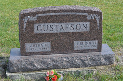
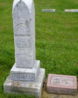
Bertha Mae Lunbom Newman Gustafson
| Birth | : | 28 Apr 1895 Manson, Calhoun County, Iowa, USA |
| Death | : | 20 Jul 1981 Dayton, Webster County, Iowa, USA |
| Burial | : | South Marion Cemetery, Stratford, Hamilton County, USA |
| Coordinate | : | 42.2327995, -93.8735962 |
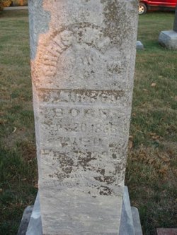
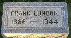
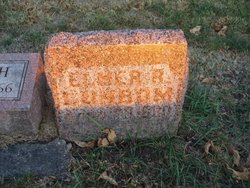
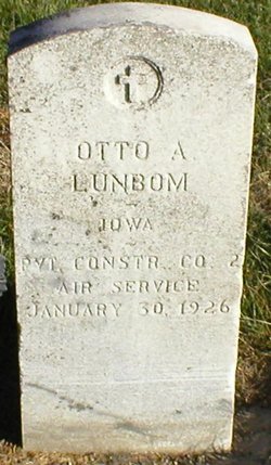
| Description | : | Daughter of Otto and Christina Sophia (Hanson) Lunbom. Her mother died shortly after her birth and she was adopted by her aunt and uncle, John Oscar and Hilda Sophia (Lunbom) Newman. She married John Rudolph Gustafson on Dec. 22, 1915 in Hamilton County, Iowa. Daily Freeman Journal July 22, 1981 Bertha Mae Gustafson STRATFORD - Bertha Mae Gustafson, 86, of Stratford, died at the Grandview Care Center in Dayton Monday. Services will be held Thursday at 2 p.m. at the Stratford First Baptist Church, Pastor Robert Haring officiating. Burial will be in the South Marion Cemetery... Read More |
frequently asked questions (FAQ):
-
Where is Bertha Mae Lunbom Newman Gustafson's memorial?
Bertha Mae Lunbom Newman Gustafson's memorial is located at: South Marion Cemetery, Stratford, Hamilton County, USA.
-
When did Bertha Mae Lunbom Newman Gustafson death?
Bertha Mae Lunbom Newman Gustafson death on 20 Jul 1981 in Dayton, Webster County, Iowa, USA
-
Where are the coordinates of the Bertha Mae Lunbom Newman Gustafson's memorial?
Latitude: 42.2327995
Longitude: -93.8735962
Family Members:

Spouse
Children
Flowers:


Nearby Cemetories:
1. South Marion Cemetery
Stratford, Hamilton County, USA
Coordinate: 42.2327995, -93.8735962
2. Oakwood Cemetery
Stratford, Hamilton County, USA
Coordinate: 42.2942009, -93.9182968
3. Mineral Ridge Cemetery
Ridgeport, Boone County, USA
Coordinate: 42.1749992, -93.9266968
4. Hooks Point Cemetery
Hamilton County, USA
Coordinate: 42.2944530, -93.9199090
5. Hardin Township Cemetery
Hardin Township, Webster County, USA
Coordinate: 42.2411003, -93.9708023
6. Saint Paul Lutheran Cemetery
Boone, Boone County, USA
Coordinate: 42.1700000, -93.8070000
7. Boone County Poor Farm Cemetery
Boone County, USA
Coordinate: 42.1591100, -93.9159000
8. White Cemetery
Boone County, USA
Coordinate: 42.1777992, -93.9636002
9. Lake Center Cemetery
Stanhope, Hamilton County, USA
Coordinate: 42.2482986, -93.7568970
10. Leininger Cemetery
Boone County, USA
Coordinate: 42.1492004, -93.8356018
11. Lawn Hill Cemetery
Stanhope, Hamilton County, USA
Coordinate: 42.2677994, -93.7611008
12. Nesse Cemetery
Hamilton County, USA
Coordinate: 42.3250008, -93.8933029
13. Neese Cemetery
Homer, Hamilton County, USA
Coordinate: 42.3250000, -93.8935000
14. Linn Cemetery
Pilot Mound, Boone County, USA
Coordinate: 42.2045330, -93.9970230
15. Vegors Cemetery
Webster County, USA
Coordinate: 42.3177986, -93.9421997
16. Mackey Cemetery
Boone County, USA
Coordinate: 42.1675000, -93.7565000
17. Runyan Cemetery
Pilot Mound, Boone County, USA
Coordinate: 42.1749992, -94.0015030
18. Saint Pauls Church Cemetery
Jewell, Hamilton County, USA
Coordinate: 42.2490100, -93.7173400
19. Schlicht Cemetery
Fraser, Boone County, USA
Coordinate: 42.1444200, -93.9780100
20. Bass Cemetery
Dayton, Webster County, USA
Coordinate: 42.2966995, -94.0149994
21. Saratoga Cemetery
Stanhope, Hamilton County, USA
Coordinate: 42.3539009, -93.8167038
22. Pilot Mound Cemetery
Pilot Mound, Boone County, USA
Coordinate: 42.1636200, -94.0282600
23. Ellsworth Clear Lake Cemetery
Randall, Hamilton County, USA
Coordinate: 42.2268930, -93.6926200
24. Bass Point Cemetery
Boone, Boone County, USA
Coordinate: 42.0992012, -93.8957977