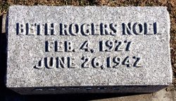
Beth Rogers Noel Pritchett
| Birth | : | 4 Feb 1927 Glasco, Cloud County, Kansas, USA |
| Death | : | 26 Jun 1942 Concordia, Cloud County, Kansas, USA |
| Burial | : | Camp Ground, Old Fort, McDowell County, USA |
| Coordinate | : | 35.6099800, -82.1651850 |
| Plot | : | 2GE28 |
| Description | : | Beth's parents were John G. Noel and Rachel Rogers. Her step-father was Carl Pritchett. Glasco Sun, July 2, 1942, page 1: Beth Rogers Noel Pritchett was born February 4th, 1927, at Glasco, and passed away at the St. Joseph Hospital in Concordia, June 26th, 1942, after an illness of but a few hours. For the past six years Beth was not permitted to enjoy good health and had to miss much she would have liked to do, but always seemed to find strength to take part in all church or school affairs, that she so loved. She was... Read More |
frequently asked questions (FAQ):
-
Where is Beth Rogers Noel Pritchett's memorial?
Beth Rogers Noel Pritchett's memorial is located at: Camp Ground, Old Fort, McDowell County, USA.
-
When did Beth Rogers Noel Pritchett death?
Beth Rogers Noel Pritchett death on 26 Jun 1942 in Concordia, Cloud County, Kansas, USA
-
Where are the coordinates of the Beth Rogers Noel Pritchett's memorial?
Latitude: 35.6099800
Longitude: -82.1651850
Family Members:
Parent
Siblings
Flowers:
Nearby Cemetories:
1. Camp Ground
Old Fort, McDowell County, USA
Coordinate: 35.6099800, -82.1651850
2. Lackey Town Missionary Baptist Church Cemetery
McDowell County, USA
Coordinate: 35.6142060, -82.1642590
3. McGhee-Mousley Graves
McDowell County, USA
Coordinate: 35.6113810, -82.1547570
4. Valley View Memorial Park
Old Fort, McDowell County, USA
Coordinate: 35.6009270, -82.1651930
5. Green Knob Cemetery - Old Fort
McDowell County, USA
Coordinate: 35.6071950, -82.1803820
6. Old Fort Free Will Baptist Church Cemetery
McDowell County, USA
Coordinate: 35.6075010, -82.1806430
7. Pittman Family Cemetery
Lackey Town, McDowell County, USA
Coordinate: 35.6245683, -82.1548288
8. Friendship Baptist Church Cemetery
McDowell County, USA
Coordinate: 35.5919283, -82.1710428
9. Friendship Baptist Church Cemetery
Old Fort, McDowell County, USA
Coordinate: 35.5919283, -82.1710428
10. Hensley Cemetery
McDowell County, USA
Coordinate: 35.6034370, -82.1420810
11. Sigmon - Laughter Family Cemetery
Oldfort, Polk County, USA
Coordinate: 35.6020486, -82.1359261
12. Old Fort City Cemetery
Old Fort, McDowell County, USA
Coordinate: 35.6347200, -82.1783600
13. Bethlehem Community Cemetery
Old Fort, McDowell County, USA
Coordinate: 35.6009320, -82.1315530
14. Adams Cemetery
Old Fort, McDowell County, USA
Coordinate: 35.6322690, -82.1884510
15. Wildcat Mountain Cemetery
Old Fort Township, McDowell County, USA
Coordinate: 35.6185075, -82.2040429
16. Bethel United Methodist Church
Old Fort, McDowell County, USA
Coordinate: 35.5816020, -82.1905890
17. Cherry Springs Memorial Park
Old Fort, McDowell County, USA
Coordinate: 35.5807040, -82.1904930
18. Old Ebenezer Cemetery
Old Fort, McDowell County, USA
Coordinate: 35.6432360, -82.1433220
19. Noblitt Graveyard
McDowell County, USA
Coordinate: 35.5690890, -82.1534230
20. Ebenezer United Methodist Church Cemetery
Old Fort, McDowell County, USA
Coordinate: 35.6497002, -82.1453018
21. Davistown Cemetery
Old Fort, McDowell County, USA
Coordinate: 35.5661011, -82.1632996
22. Pine Cove Cemetery
McDowell County, USA
Coordinate: 35.5774994, -82.2063980
23. Piney Grove Baptist Church Cemetery
Old Fort, McDowell County, USA
Coordinate: 35.6348140, -82.2239530
24. Silver Family Cemetery
McDowell County, USA
Coordinate: 35.6700880, -82.1905720

