
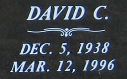

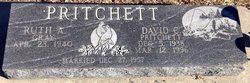
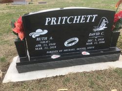
David Carl Pritchett
| Birth | : | 5 Dec 1938 Glasco, Cloud County, Kansas, USA |
| Death | : | 12 Mar 1996 Olathe, Johnson County, Kansas, USA |
| Burial | : | Glasco Cemetery, Glasco, Cloud County, USA |
| Coordinate | : | 39.3574000, -97.8265000 |
| Plot | : | 106W29 |
| Description | : | Cloud County Cemetery Book, Volume 4, page 123 Married Dec. 27, 1957, Ruth A. Gray ******************** Salina Journal Thursday, March 14, 1996 David Carl Pritchett OLATHE David Carl Pritchett, 57, Olathe, died Tuesday, March 12, 1996, at Olathe Medical Center. Mr. Pritchett was born Dec. 5, 1938, at Glasco. He was a Navy veteran. He was a cable splicer for Southwestern Bell Telephone Co. for 30 years and was of the Methodist faith. Survivors include his wife, Ruth Ann of the home; three sons, Michael David of Stanley, Dennis Wayne of Greeley and Steven Douglas of Moore, Okla.; a brother, James of Virginia... Read More |
frequently asked questions (FAQ):
-
Where is David Carl Pritchett's memorial?
David Carl Pritchett's memorial is located at: Glasco Cemetery, Glasco, Cloud County, USA.
-
When did David Carl Pritchett death?
David Carl Pritchett death on 12 Mar 1996 in Olathe, Johnson County, Kansas, USA
-
Where are the coordinates of the David Carl Pritchett's memorial?
Latitude: 39.3574000
Longitude: -97.8265000
Family Members:
Parent

Spouse

Siblings
Flowers:


Nearby Cemetories:
1. Glasco Cemetery
Glasco, Cloud County, USA
Coordinate: 39.3574000, -97.8265000
2. Saint Marys Catholic Cemetery
Glasco, Cloud County, USA
Coordinate: 39.3574000, -97.8245000
3. Simpson Cemetery
Simpson, Mitchell County, USA
Coordinate: 39.3633003, -97.9471970
4. Bethel Cemetery
Meredith Township, Cloud County, USA
Coordinate: 39.3506000, -97.7029000
5. Delphos Cemetery
Delphos, Ottawa County, USA
Coordinate: 39.2778015, -97.7416992
6. Saint Paul Cemetery
Delphos, Ottawa County, USA
Coordinate: 39.2677994, -97.7518997
7. Asherville Cemetery
Asherville, Mitchell County, USA
Coordinate: 39.4205000, -97.9672900
8. Morrison Cemetery
Center Township, Cloud County, USA
Coordinate: 39.4817009, -97.7975006
9. Summit Cemetery
Jamestown, Cloud County, USA
Coordinate: 39.4813200, -97.8628800
10. Green Mound Cemetery
Asherville, Mitchell County, USA
Coordinate: 39.3203011, -97.9858017
11. Coursen Grove Cemetery
Simpson, Mitchell County, USA
Coordinate: 39.3060989, -97.9792023
12. Hall Cemetery
Cloud County, USA
Coordinate: 39.4455986, -97.7033005
13. Saint Peters Cemetery
Miltonvale, Cloud County, USA
Coordinate: 39.3652350, -97.6483570
14. Bell-Bogardus Cemetery
Asherville, Mitchell County, USA
Coordinate: 39.4242410, -97.9919970
15. Bohemian National Cemetery
Ada, Ottawa County, USA
Coordinate: 39.2193870, -97.9054030
16. Wilcox Cemetery
Cloud County, USA
Coordinate: 39.4925003, -97.7313995
17. West Asher Cemetery
Scottsville, Mitchell County, USA
Coordinate: 39.4815000, -97.9661600
18. Baldwin Cemetery
Ottawa County, USA
Coordinate: 39.2061005, -97.9111023
19. Kindel Cemetery
Center Township, Cloud County, USA
Coordinate: 39.4519005, -97.6464005
20. Smith Cemetery
Asherville, Mitchell County, USA
Coordinate: 39.4516690, -98.0098850
21. McBride Cemetery
Beloit, Mitchell County, USA
Coordinate: 39.4808006, -97.9907990
22. Enterprise Cemetery
Cloud County, USA
Coordinate: 39.4230995, -97.6106033
23. Shiloh Cemetery
Beloit, Mitchell County, USA
Coordinate: 39.3574982, -98.0594025
24. Summit Cemetery #3
Macyville, Cloud County, USA
Coordinate: 39.5258330, -97.9194440