
| Birth | : | 5 Apr 1775 Norton, Bristol County, Massachusetts, USA |
| Death | : | 2 Feb 1816 Norton, Bristol County, Massachusetts, USA |
| Burial | : | South Elkhorn Cemetery, South Elkhorn, Carroll County, USA |
| Coordinate | : | 41.9672203, -89.7125015 |
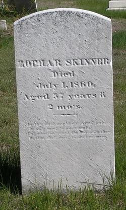
| Inscription | : | To the memory of Mrs. Bethiah wife of Mr. Zophar Skinner who died Feb. 2, 1816 Aged 40 years |
frequently asked questions (FAQ):
-
Where is Bethiah Freeman Skinner's memorial?
Bethiah Freeman Skinner's memorial is located at: South Elkhorn Cemetery, South Elkhorn, Carroll County, USA.
-
When did Bethiah Freeman Skinner death?
Bethiah Freeman Skinner death on 2 Feb 1816 in Norton, Bristol County, Massachusetts, USA
-
Where are the coordinates of the Bethiah Freeman Skinner's memorial?
Latitude: 41.9672203
Longitude: -89.7125015
Family Members:
Parent

Spouse
Siblings
Children
Flowers:


Nearby Cemetories:
1. South Elkhorn Cemetery
South Elkhorn, Carroll County, USA
Coordinate: 41.9672203, -89.7125015
2. Brick Church Cemetery
Polo, Ogle County, USA
Coordinate: 41.9735603, -89.6671600
3. Eagle Point Cemetery
Polo, Ogle County, USA
Coordinate: 41.9955406, -89.6846695
4. Webster Family Cemetery
Polo, Ogle County, USA
Coordinate: 41.9615288, -89.6521530
5. Union Cemetery
Milledgeville, Carroll County, USA
Coordinate: 42.0019417, -89.7533264
6. Nichols Cemetery
Polo, Ogle County, USA
Coordinate: 41.9700012, -89.6500015
7. Hill Top Cemetery
Jordan Township, Whiteside County, USA
Coordinate: 41.9163934, -89.6882153
8. Bethel Cemetery
Milledgeville, Carroll County, USA
Coordinate: 41.9440700, -89.7829260
9. Schriner Cemetery
Lanark, Carroll County, USA
Coordinate: 42.0374985, -89.7427826
10. Reed Cemetery
Polo, Ogle County, USA
Coordinate: 41.9730988, -89.6113968
11. Dutchtown Church of the Brethren Cemetery
Milledgeville, Carroll County, USA
Coordinate: 41.9741130, -89.8174290
12. East Jordan Cemetery
Sterling, Whiteside County, USA
Coordinate: 41.9018100, -89.6481050
13. Brookville United Methodist Cemetery
Brookville, Ogle County, USA
Coordinate: 42.0455589, -89.6761322
14. Hazel Green Cemetery
Genesee Township, Whiteside County, USA
Coordinate: 41.9241700, -89.8104540
15. Durley Gravesite
Polo, Ogle County, USA
Coordinate: 41.9912987, -89.6033554
16. Penrose Friends Cemetery
Penrose, Whiteside County, USA
Coordinate: 41.8856860, -89.6685210
17. Brookville Lutheran Cemetery
Carroll County, USA
Coordinate: 42.0550003, -89.6872177
18. Maple Ridge Cemetery
Sterling, Whiteside County, USA
Coordinate: 41.8774986, -89.7244034
19. Buffalo Grove Cemetery
Buffalo Grove, Ogle County, USA
Coordinate: 41.9794197, -89.5920410
20. Saint Mary Cemetery
Polo, Ogle County, USA
Coordinate: 41.9989014, -89.5777969
21. Fairmount Cemetery
Polo, Ogle County, USA
Coordinate: 42.0005989, -89.5766983
22. Genesee Grove Central Cemetery
Coleta, Whiteside County, USA
Coordinate: 41.9026290, -89.8413490
23. East Genesee Cemetery
Coleta, Whiteside County, USA
Coordinate: 41.8574982, -89.7660980
24. Oak Knoll Memorial Park Cemetery
Sterling, Whiteside County, USA
Coordinate: 41.8496857, -89.7071533