
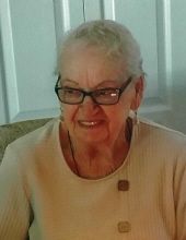
Betty Jean Goddard Miller
| Birth | : | 9 May 1929 Garden City, Finney County, Kansas, USA |
| Death | : | 17 Jan 2021 Aurora, Adams County, Colorado, USA |
| Burial | : | Fort Lyon National Cemetery, Fort Lyon, Bent County, USA |
| Coordinate | : | 38.0847015, -103.1288986 |
| Plot | : | Section F Row 1 Site E |
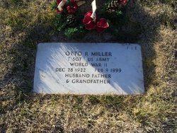
| Description | : | Betty Jean Miller, 91, passed away on January 17, 2021 in Aurora, Colorado after living in La Junta for many years. She was born in Garden City, Kansas on May 9, 1929 to Benjamin and Ethel Goddard. She was the second youngest of eight children. She met and fell in love with Otto Miller when she was 16. They were married 2 weeks later. They were married up until he passed away in 1999. They had three children, Roger (Litsa) Miller of Aurora, Colorado; Deann (Rod) Ormsbee of Fort Morgan, Colorado and Janice (Randy) Musgrave of Fort Morgan, Colorado;... Read More |
frequently asked questions (FAQ):
-
Where is Betty Jean Goddard Miller's memorial?
Betty Jean Goddard Miller's memorial is located at: Fort Lyon National Cemetery, Fort Lyon, Bent County, USA.
-
When did Betty Jean Goddard Miller death?
Betty Jean Goddard Miller death on 17 Jan 2021 in Aurora, Adams County, Colorado, USA
-
Where are the coordinates of the Betty Jean Goddard Miller's memorial?
Latitude: 38.0847015
Longitude: -103.1288986
Family Members:
Flowers:


Nearby Cemetories:
1. Fort Lyon National Cemetery
Fort Lyon, Bent County, USA
Coordinate: 38.0847015, -103.1288986
2. Fort Lyon Post Cemetery
Bent County, USA
Coordinate: 38.0427000, -103.0757000
3. Boggsville National Historic Site Grounds
Boggsville, Bent County, USA
Coordinate: 38.0425130, -103.2102730
4. Las Animas Cemetery
Las Animas, Bent County, USA
Coordinate: 38.0424995, -103.2174988
5. Union Valley Cemetery
Hasty, Bent County, USA
Coordinate: 38.0960999, -102.9574966
6. Indian Rock Cemetery
Bent County, USA
Coordinate: 37.9550018, -102.9630966
7. Home Cemetery
McClave, Bent County, USA
Coordinate: 38.1218987, -102.8497009
8. Bents Old Fort Cemetery
La Junta, Otero County, USA
Coordinate: 38.0416000, -103.4297000
9. Saint Paul’s Lutheran Cemetery
Otero County, USA
Coordinate: 38.0342000, -103.4542000
10. East Holbrook Mennonite Cemetery
Cheraw, Otero County, USA
Coordinate: 38.1101837, -103.4729767
11. Little Kansas Cemetery
Bent County, USA
Coordinate: 37.9399986, -102.8274994
12. Arlington Cemetery
Arlington, Kiowa County, USA
Coordinate: 38.3232994, -103.3597031
13. Hight Cemetery
Bent County, USA
Coordinate: 38.0264015, -102.7508011
14. Wiley Cemetery
Bent County, USA
Coordinate: 38.1688995, -102.7422028
15. Bethel Cemetery
Bent County, USA
Coordinate: 37.7888985, -102.9664001
16. Holbrook Cemetery
Otero County, USA
Coordinate: 38.0842018, -103.5432968
17. Saint Andrews Episcopal Church Columbarium
La Junta, Otero County, USA
Coordinate: 37.9809000, -103.5455000
18. Fairview Cemetery
La Junta, Otero County, USA
Coordinate: 37.9873000, -103.5607000
19. Calvary Cemetery
La Junta, Otero County, USA
Coordinate: 37.9832000, -103.5622000
20. Haswell Cemetery
Haswell, Kiowa County, USA
Coordinate: 38.4472000, -103.1726000
21. Ormega Cemetery
La Junta, Otero County, USA
Coordinate: 37.9684000, -103.5770000
22. Crawford Cemetery
Prowers County, USA
Coordinate: 38.1239014, -102.6585999
23. Pruett Cemetery
Bent County, USA
Coordinate: 37.7172012, -103.2897034
24. Riverside Cemetery
Lamar, Prowers County, USA
Coordinate: 38.0932999, -102.6072006