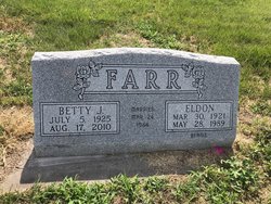
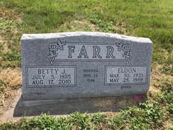
Betty Jean Hilker Farr
| Birth | : | 5 Jul 1925 Furnas County, Nebraska, USA |
| Death | : | 17 Aug 2010 Kearney, Buffalo County, Nebraska, USA |
| Burial | : | Holbrook Cemetery, Holbrook, Furnas County, USA |
| Coordinate | : | 40.3138000, -100.0045000 |
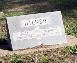
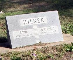
| Description | : | Betty Jean Farr, 85, of Kearney, formerly of Holdrege, died Tuesday, Aug. 17, 2010, at Mount Carmel Home Keens Memorial in Kearney. Memorial services will be at 10 a.m. Monday at Nelson-Bauer Funeral Home in Holdrege with the Rev. Kenton Birtell officiating. Burial of cremains will be at Holbrook Cemetery. She was born July 5, 1925, on a farm north of Holbrook to William and Anna (Rupp) Hilker. On March 24, 1944, she married Eldon Farr in Oberlin, Kan. He died in 1989. Survivors include her sons, Larry of Kearney and Lynn of Arkansas; brother, Billy Hilker of Axtell; sisters, Shirley Balcom of... Read More |
frequently asked questions (FAQ):
-
Where is Betty Jean Hilker Farr's memorial?
Betty Jean Hilker Farr's memorial is located at: Holbrook Cemetery, Holbrook, Furnas County, USA.
-
When did Betty Jean Hilker Farr death?
Betty Jean Hilker Farr death on 17 Aug 2010 in Kearney, Buffalo County, Nebraska, USA
-
Where are the coordinates of the Betty Jean Hilker Farr's memorial?
Latitude: 40.3138000
Longitude: -100.0045000
Family Members:
Parent
Spouse
Siblings
Children
Flowers:
Nearby Cemetories:
1. Holbrook Cemetery
Holbrook, Furnas County, USA
Coordinate: 40.3138000, -100.0045000
2. Norwegian Lutheran Cemetery
Holbrook, Furnas County, USA
Coordinate: 40.3380910, -100.0425560
3. Miller Cemetery
Elwood, Gosper County, USA
Coordinate: 40.3514980, -100.0374350
4. Saint Matthew Lutheran Cemetery
Elwood, Gosper County, USA
Coordinate: 40.3519000, -99.9630000
5. Arapahoe Cemetery
Arapahoe, Furnas County, USA
Coordinate: 40.3239600, -99.8985500
6. Garfield Cemetery
Furnas County, USA
Coordinate: 40.2491989, -99.8992004
7. East Muddy Cemetery
Gosper County, USA
Coordinate: 40.4166985, -99.9614029
8. Pleasantview Cemetery
Arapahoe, Furnas County, USA
Coordinate: 40.2043991, -99.9669037
9. Saint John's Catholic Cemetery
Cambridge, Furnas County, USA
Coordinate: 40.2850000, -100.1817000
10. Fairview Cemetery
Cambridge, Furnas County, USA
Coordinate: 40.2849998, -100.1817017
11. Immanuel Lutheran Cemetery
Elwood, Gosper County, USA
Coordinate: 40.4206500, -99.8672000
12. McGuire Cemetery
Gosper County, USA
Coordinate: 40.4380989, -99.8664017
13. Pleasant Grove Cemetery
Gosper County, USA
Coordinate: 40.4664001, -99.9250031
14. Edison Cemetery
Edison, Furnas County, USA
Coordinate: 40.2919006, -99.7902985
15. Salem West Cemetery
Frontier County, USA
Coordinate: 40.4968987, -99.9886017
16. Stowe Cemetery
Stockville, Frontier County, USA
Coordinate: 40.4900017, -100.0753021
17. Salem East Cemetery
Gosper County, USA
Coordinate: 40.4972000, -99.9803009
18. Stump Cemetery
Furnas County, USA
Coordinate: 40.3478012, -99.7621994
19. Homerville Cemetery
Gosper County, USA
Coordinate: 40.4668999, -99.8593979
20. Hendley Cemetery
Hendley, Furnas County, USA
Coordinate: 40.1186000, -99.9939000
21. Hammond Cemetery
Frontier County, USA
Coordinate: 40.4002953, -100.2353134
22. Denny Cemetery
Frontier County, USA
Coordinate: 40.4393997, -100.2082977
23. Mount Hope Cemetery
Beaver City, Furnas County, USA
Coordinate: 40.1333008, -99.8518982
24. Wilsonville Cemetery
Wilsonville, Furnas County, USA
Coordinate: 40.1107941, -100.1154022

