
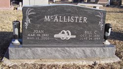
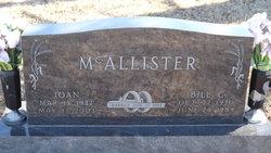
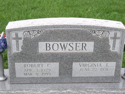
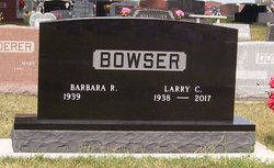
Betty “Joan” Bowser McAllister
| Birth | : | 13 Mar 1932 Larkinburg, Atchison County, Kansas, USA |
| Death | : | 12 May 2003 Topeka, Shawnee County, Kansas, USA |
| Burial | : | South Lead Cemetery, Lead, Lawrence County, USA |
| Coordinate | : | 44.3478510, -103.7606260 |
| Plot | : | Section LL |
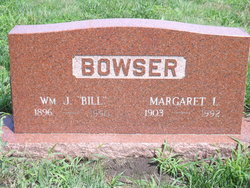
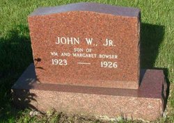
| Description | : | HOLTON -- Betty "Joan" McAllister, 71, Holton, died Tuesday, May 12, 2003, at a Topeka hospital. Mrs. McAllister worked 23 years for the U.S. Department of Agriculture Farm Service Agency before retiring in 1994. She was born March 13, 1932, in Larkinburg, to William J. and Margaret Kinkade Bowser. She graduated from Atchison County High School in 1950 and was a lifelong resident of the Holton area. Mrs. McAllister was a member of Larkinburg Christian Church, Liberty Ladies Club and a volunteer with the Jackson County Friends of Hospice. She also was a member of the National Association of Retired Federal Employees. She... Read More |
frequently asked questions (FAQ):
-
Where is Betty “Joan” Bowser McAllister's memorial?
Betty “Joan” Bowser McAllister's memorial is located at: South Lead Cemetery, Lead, Lawrence County, USA.
-
When did Betty “Joan” Bowser McAllister death?
Betty “Joan” Bowser McAllister death on 12 May 2003 in Topeka, Shawnee County, Kansas, USA
-
Where are the coordinates of the Betty “Joan” Bowser McAllister's memorial?
Latitude: 44.3478510
Longitude: -103.7606260
Family Members:
Parent

Spouse
Siblings

Flowers:


Nearby Cemetories:
1. West Lead Cemetery
Lead, Lawrence County, USA
Coordinate: 44.3484001, -103.7779999
2. Mount Moriah Cemetery
Deadwood, Lawrence County, USA
Coordinate: 44.3760986, -103.7253036
3. Saint Ambrose Cemetery
Deadwood, Lawrence County, USA
Coordinate: 44.3821983, -103.7266998
4. Terry Cemetery
Terry, Lawrence County, USA
Coordinate: 44.3344290, -103.8165110
5. Oak Ridge Cemetery
Deadwood, Lawrence County, USA
Coordinate: 44.3891983, -103.6766968
6. Holy Cross Cemetery
Englewood, Lawrence County, USA
Coordinate: 44.2818985, -103.8047028
7. Mountain Lawn Cemetery
Englewood, Lawrence County, USA
Coordinate: 44.2818985, -103.8047028
8. Galena Cemetery
Galena, Lawrence County, USA
Coordinate: 44.3349220, -103.6438410
9. Preston Ghost Town Cemetery
Preston, Lawrence County, USA
Coordinate: 44.3577500, -103.8871670
10. Carbonate Cemetery
Maurice, Lawrence County, USA
Coordinate: 44.4000000, -103.8680500
11. Roubaix Cemetery
Roubaix, Lawrence County, USA
Coordinate: 44.2789380, -103.6656600
12. Dumont Cemetery
Lawrence County, USA
Coordinate: 44.2270000, -103.7860000
13. Carr Cemetery
Hanna, Lawrence County, USA
Coordinate: 44.2411003, -103.8606033
14. Crook City Cemetery
Crook City, Lawrence County, USA
Coordinate: 44.4432100, -103.6241500
15. Anderson Cemetery
Lawrence County, USA
Coordinate: 44.4747009, -103.6896973
16. Whitewood Cemetery
Whitewood, Lawrence County, USA
Coordinate: 44.4617820, -103.6330030
17. Rose Hill Cemetery
Spearfish, Lawrence County, USA
Coordinate: 44.4802180, -103.8509270
18. Mountain Meadow Cemetery
Lawrence County, USA
Coordinate: 44.2038994, -103.6557999
19. Saint Aloysius Cemetery
Sturgis, Meade County, USA
Coordinate: 44.4141340, -103.5193420
20. Little Dane Cemetery
Saint Onge, Lawrence County, USA
Coordinate: 44.5252500, -103.6705540
21. Gate of Heaven Cemetery
Saint Onge, Lawrence County, USA
Coordinate: 44.5353000, -103.7237000
22. Bear Gulch Cemetery
Lawrence County, USA
Coordinate: 44.3819008, -104.0325012
23. Bear Butte Cemetery
Sturgis, Meade County, USA
Coordinate: 44.4111595, -103.4947968
24. Black Hills National Cemetery
Sturgis, Meade County, USA
Coordinate: 44.3689003, -103.4753036