
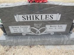

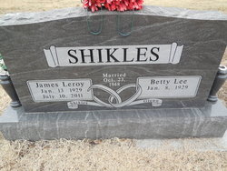
Betty Lee Glenn Shikles
| Birth | : | 8 Jan 1929 Russelville, Webster County, Missouri, USA |
| Death | : | 1 Jan 2018 Boonville Township, Cooper County, Missouri, USA |
| Burial | : | Enloe Cemetery, Moniteau County, USA |
| Coordinate | : | 38.5074997, -92.4741974 |
| Inscription | : | Shikles married Oct. 23, 1948 |
| Description | : | Betty Lee Shikles, 88, of Boonville, passed away Monday, January 1, 2018, at Cooper County Memorial Hospital in Boonville, Missouri. She was born January 8, 1929, in Russellville, Missouri, the daughter of the late Herbert and Nancy Ellen (Myers) Glenn. She was united in marriage on October 23, 1948, at the Enon Baptist Church parsonage in Enon, Missouri to James Leroy Shikles who preceded her in death on July 10, 2011. At the age of 16, when her mother passed away, Betty helped her father to raise her siblings and also helped to work on the family farm. When Betty... Read More |
frequently asked questions (FAQ):
-
Where is Betty Lee Glenn Shikles's memorial?
Betty Lee Glenn Shikles's memorial is located at: Enloe Cemetery, Moniteau County, USA.
-
When did Betty Lee Glenn Shikles death?
Betty Lee Glenn Shikles death on 1 Jan 2018 in Boonville Township, Cooper County, Missouri, USA
-
Where are the coordinates of the Betty Lee Glenn Shikles's memorial?
Latitude: 38.5074997
Longitude: -92.4741974
Family Members:
Spouse
Children
Flowers:


Nearby Cemetories:
1. Enloe Cemetery
Moniteau County, USA
Coordinate: 38.5074997, -92.4741974
2. Belleville Cemetery
Russellville, Cole County, USA
Coordinate: 38.4970490, -92.4667150
3. Enon Cemetery
Russellville, Cole County, USA
Coordinate: 38.4888992, -92.4730988
4. Karnes-Carney-Henderson Cemetery
Burris Fork, Moniteau County, USA
Coordinate: 38.4992100, -92.5007510
5. Saint Michael Cemetery
Russellville, Cole County, USA
Coordinate: 38.5109300, -92.4429100
6. Evangelical Lutheran Cemetery One Acre
Russellville, Cole County, USA
Coordinate: 38.5175667, -92.4415817
7. Buckner Russell Cemetery
Cole County, USA
Coordinate: 38.5136900, -92.4359390
8. Van Pool Cemetery
Moniteau County, USA
Coordinate: 38.5372009, -92.4627991
9. Russellville Cemetery
Russellville, Cole County, USA
Coordinate: 38.5196991, -92.4366989
10. Trinity Lutheran Cemetery
Russellville, Cole County, USA
Coordinate: 38.5028000, -92.4317017
11. Karnes Cemetery
Corticelli, Moniteau County, USA
Coordinate: 38.5099700, -92.5247900
12. Campbell Cemetery
Cole County, USA
Coordinate: 38.4810982, -92.4297028
13. Blank Cemetery
Russellville, Cole County, USA
Coordinate: 38.5203018, -92.4180984
14. DeFoe Cemetery
California, Moniteau County, USA
Coordinate: 38.5416985, -92.5250015
15. Rock Enon Cemetery
Miller County, USA
Coordinate: 38.4668400, -92.5170700
16. Bruce-Lewis-McGahan Cemetery
Enon, Moniteau County, USA
Coordinate: 38.4667500, -92.5172100
17. Roark Cemetery
Russellville, Cole County, USA
Coordinate: 38.4696999, -92.4255981
18. Matheis Cemetery
Russellville, Cole County, USA
Coordinate: 38.4571800, -92.4491600
19. Barnhardt Cemetery
Lohman, Cole County, USA
Coordinate: 38.5537900, -92.4267100
20. Clibourn Cemetery
Russellville, Cole County, USA
Coordinate: 38.4760500, -92.3973500
21. Marney Family Cemetery
High Point, Moniteau County, USA
Coordinate: 38.5357900, -92.5614500
22. Jackson Chapel Methodist Church Cemetery
California, Moniteau County, USA
Coordinate: 38.4447900, -92.5286500
23. Yarnell Cemetery
California, Moniteau County, USA
Coordinate: 38.5189018, -92.5708008
24. Gray Cemetery
Moniteau County, USA
Coordinate: 38.4536018, -92.5456009