
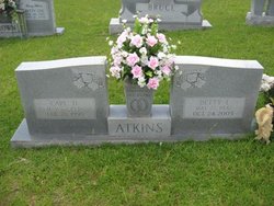
Betty Lou Plumley Atkins
| Birth | : | 27 May 1942 Greenville County, South Carolina, USA |
| Death | : | 24 Oct 2005 Greenville, Greenville County, South Carolina, USA |
| Burial | : | St. Peter's Anglican Cemetery, Ōnehunga, Auckland Council, New Zealand |
| Coordinate | : | -36.9227113, 174.7847550 |
| Description | : | Published in The Greenville News: 10-26-2005 Landrum - Betty Lou Plumley Atkins, 63, of 438 Dill Road, died Oct. 24, 2005, at Greenville Memorial Hospital. A native of Greenville County, she was the daughter of the late Ralph and Vincie Pace Plumley and was the wife of the late Carl Donald Atkins. She was a member of Ebenezer Welcome Baptist Church and retired from Collins and Aikman Textiles. She is survived by two sons, James Atkins and wife, Cyndi, of Landrum, and Ricky Atkins and wife, Rhonda, of Landrum; a daughter, Glenda Pace and husband, Glenn, of Landrum; a brother,... Read More |
frequently asked questions (FAQ):
-
Where is Betty Lou Plumley Atkins's memorial?
Betty Lou Plumley Atkins's memorial is located at: St. Peter's Anglican Cemetery, Ōnehunga, Auckland Council, New Zealand.
-
When did Betty Lou Plumley Atkins death?
Betty Lou Plumley Atkins death on 24 Oct 2005 in Greenville, Greenville County, South Carolina, USA
-
Where are the coordinates of the Betty Lou Plumley Atkins's memorial?
Latitude: -36.9227113
Longitude: 174.7847550
Family Members:
Spouse
Children

Flowers:


Nearby Cemetories:
1. St. Peter's Anglican Cemetery
Ōnehunga, Auckland Council, New Zealand
Coordinate: -36.9227113, 174.7847550
2. Onehunga Catholic Cemetery
Ōnehunga, Auckland Council, New Zealand
Coordinate: -36.9224360, 174.7884560
3. Our Lady of the Assumption Catholic Church
Ōnehunga, Auckland Council, New Zealand
Coordinate: -36.9223690, 174.7884530
4. Waikaraka Cemetery
Ōnehunga, Auckland Council, New Zealand
Coordinate: -36.9297140, 174.7967170
5. Mangere Piriti Urupā St. James Churchyard
Mangere, Auckland Council, New Zealand
Coordinate: -36.9418970, 174.7835260
6. Hillsborough Cemetery
Hillsborough, Auckland Council, New Zealand
Coordinate: -36.9246600, 174.7524030
7. Saint Andrew's Churchyard
Epsom, Auckland Council, New Zealand
Coordinate: -36.8937200, 174.7654100
8. Mangere Lawn Cemetery
Mangere, Auckland Council, New Zealand
Coordinate: -36.9626150, 174.7857000
9. Otahuhu Public Cemetery
Ōtāhūhū, Auckland Council, New Zealand
Coordinate: -36.9377500, 174.8432390
10. St Mark's Anglican Church Cemetery
Remuera, Auckland Council, New Zealand
Coordinate: -36.8729300, 174.7801600
11. Holy Trinity Memorial Park
Ōtāhūhū, Auckland Council, New Zealand
Coordinate: -36.9374510, 174.8448580
12. Mangere Presbyterian Cemetery
Mangere, Auckland Council, New Zealand
Coordinate: -36.9750197, 174.7924783
13. Nixon Memorial
Ōtāhūhū, Auckland Council, New Zealand
Coordinate: -36.9499366, 174.8449909
14. St. Joseph and St. Joachim Catholic Cemetery
Ōtāhūhū, Auckland Council, New Zealand
Coordinate: -36.9436100, 174.8490100
15. Mount Eden Stockade Cemetery
Mount Eden, Auckland Council, New Zealand
Coordinate: -36.8678370, 174.7666430
16. St. Patrick's Roman Catholic Church Cemetery
Panmure, Auckland Council, New Zealand
Coordinate: -36.9029680, 174.8564960
17. St Matthias Churchyard
Panmure, Auckland Council, New Zealand
Coordinate: -36.9053300, 174.8577200
18. St. Luke's Anglican Church Cemetery
Mount Albert, Auckland Council, New Zealand
Coordinate: -36.8785540, 174.7290400
19. Purewa Cemetery
Meadowbank, Auckland Council, New Zealand
Coordinate: -36.8674300, 174.8297900
20. Symonds Street Cemetery
Auckland, Auckland Council, New Zealand
Coordinate: -36.8582828, 174.7636628
21. St. John’s College Graveyard
Saint Johns, Auckland Council, New Zealand
Coordinate: -36.8738169, 174.8416826
22. Ōrākei (Rautara St) Urupā
Orakei, Auckland Council, New Zealand
Coordinate: -36.8610770, 174.8188960
23. St. Stephen's Churchyard
Auckland, Auckland Council, New Zealand
Coordinate: -36.8504860, 174.7899970
24. Point England Presbyterian Cemetery
Point England, Auckland Council, New Zealand
Coordinate: -36.8823420, 174.8601550